Report on Pinatubo (Philippines) — September 1992

Bulletin of the Global Volcanism Network, vol. 17, no. 9 (September 1992)
Managing Editor: Lindsay McClelland.
Pinatubo (Philippines) Lava-dome growth; pyroclastic-flow deposits spawn destructive lahars and secondary explosions
Please cite this report as:
Global Volcanism Program, 1992. Report on Pinatubo (Philippines) (McClelland, L., ed.). Bulletin of the Global Volcanism Network, 17:9. Smithsonian Institution. https://doi.org/10.5479/si.GVP.BGVN199209-273083
Pinatubo
Philippines
15.13°N, 120.35°E; summit elev. 1486 m
All times are local (unless otherwise noted)
The following is from a report by PHIVOLCS. The powerful explosive eruption of June 1991 deposited about 9 km3 of material, forming a caldera about 2 km in diameter and 650 m deep. Rain from the succeeding wet season partially filled the caldera, forming a shallow lake of about 1 km2 (figure 26).
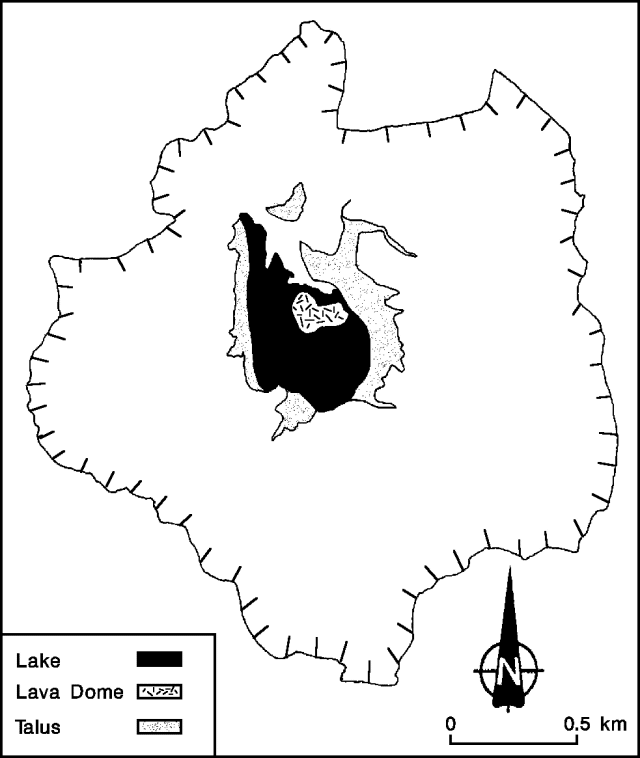 |
Figure 26. Sketch of the caldera at Pinatubo, 2 September 1992. The lava dome is shown near the center of the caldera lake. Talus from the walls encroaches on the lake shore. Courtesy of PHIVOLCS. |
Summit activity and seismicity, 1 July-15 October 1992. Pinatubo showed signs of renewed activity beginning in early July 1992, when low-frequency earthquakes and tremor, indicating movement of magma to shallower levels beneath the caldera, increased and began to dominate the seismic records. By 9 July, phreatic explosions near the center of the caldera lake had built an ash cone 100 m in diameter that extended 5 m above the lake surface. Lava extrusion then began, and by 14 July, a dome 100 m across and 10 m high had grown near the center of the ash cone, which had widened to around 200 m. COSPEC measurements during the 2nd week in July recorded SO2 emission rates of 150-600 t/d. By 22 July, the lava dome had grown to 200-250 m in diameter and 50 m high.
Another increase in the number of low-frequency earthquakes was recorded 6-9 August (figure 27), coinciding with a decrease in the SO2 emission rate to around 250 t/d, from 800-900 t/d during the last week in July and the beginning of August. Similar patterns were noted several days before the 1991 explosive eruptions (although the SO2 flux was about 3-5 times higher in 1991), probably because rising magma clogged the path of escaping volcanic gases. Because of these similarities, on 9 August PHIVOLCS announced the possibility that an explosive eruption might occur within a week. By 11 August, the dome had reached 300 m in N-S dimension and approximately 100 m height. Part of the crater floor on the N side of the dome was uplifted, possibly indicating that most of the dome-building activity was concentrated there. The activity did not lead to an explosive eruption, and the unrest seemed to subside 11-16 August as the number of earthquakes decreased. SO2 emission rates ranged from 650 to 1150 t/d 13-16 August, but decreased again to around 220 t/d by 23 August.
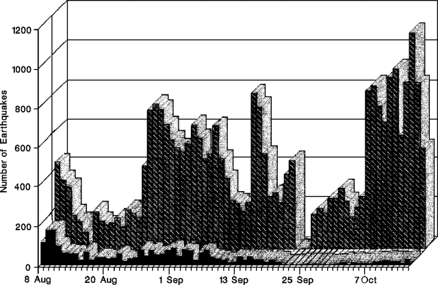 |
Figure 27. Number of earthquakes recorded at Pinatubo by a seismic station (CRAZ) on the caldera's N rim, 8 August-14 October, 1992. Courtesy of PHIVOLCS. |
Seismic activity increased again in late August, and has continued since then at a high level. The seismograph (CRAZ) installed on the caldera's N rim on 7 August has recorded at least 200 earthquakes/day, and daily counts reached as many as 1,100 (during the second week in October). Seismic records were dominated by low-frequency events. Because of the sustained high level of seismicity, the possibility of explosive eruptions persists.
Dome growth has occurred intermittently. By 26 August, the caldera floor on the E side of the dome was uplifted, and dome-building activity shifted to that side. The E-W dimension of the dome was about 340 m by 2 September. Talus deposition from heavy rains at the end of August has caused encroachment of the E shore of the lake toward the dome (figure 26). Continued rains during the first two weeks in September caused further encroachment of the E shoreline, filling the E part of the lake. The dome's size was estimated at 300 m N-S and 400 m E-W on 25 September. SO2 flux measured that day remained low at 290 t/d.
Lahars. Rains spawned by typhoons and the southwest monsoon triggered small to moderate lahars during June and July along channels of the following rivers: O'Donnel-Tarlac (NE flank); Sacobia-Bamban (E flank); Pasig-Potrero (SE flank); Marella-Santo Tomas (SW flank); and Bucao (NW flank) (figure 28). Almost all of the lahars along these rivers were confined within their channels and did not cause significant damage. No lahars flowed down the Abacan River (E flank) because it had been cut off from pyroclastic-flow deposits in its headwaters by the effects of a secondary explosion on 4 April.
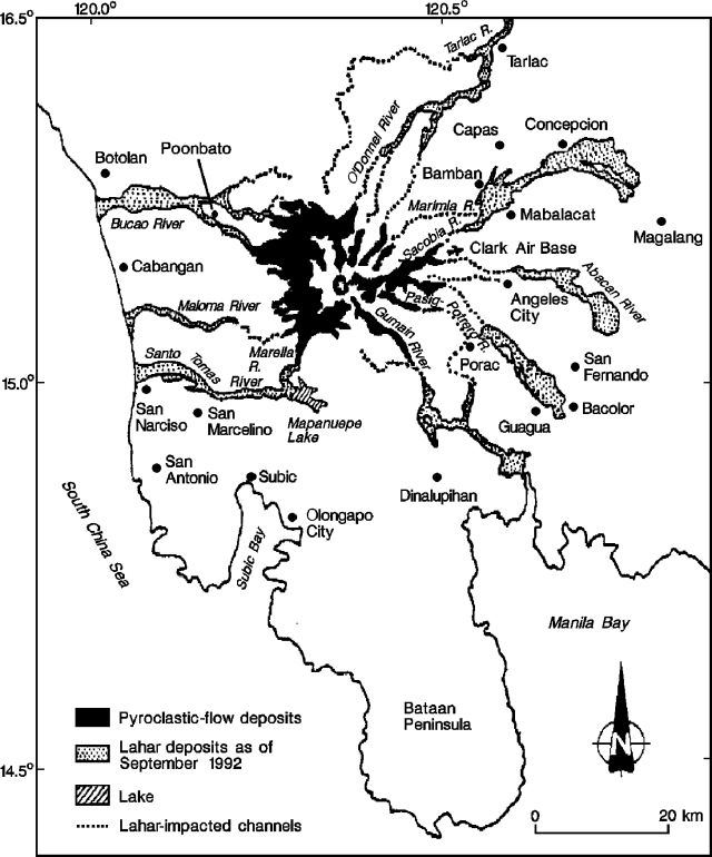 |
Figure 28. Sketch map showing Pinatubo's major drainages, and their pyroclastic-flow and lahar deposits as of September 1992. Courtesy of PHIVOLCS. |
Typhoons passing across N Luzon and normal monsoonal rainfall triggered larger lahar flows in August and September that caused casualties and damage in several barangays (communities). On the E side of the volcano (along the Sacobia-Bamban River), lahars buried the northern barangays of the Mabalacat area to 3-4 m depth and parts of the Bamban area to 1-3 m depth between 28 and 30 August. The section of the Bamban River channel near the bridge connecting the towns of Mabalacat and Bamban was aggraded by 4.5 km of lahar material, and the bridge's floor was covered by 0.5 m of lahar deposits. The town of Bamban was also affected by flooding caused by breaching of a natural dam in a tributary of the Bamban River (the Marimla), made by lahar deposits that had come down the Sacobia River. On 3-5 September, lahars in the Sacobia-Bamban drainage destroyed the NE-corner fence of Clark Air Base and inundated a barangay near Mabalacat (Dolores) to 2-4 m depth. The 29 August lahars along the Pasig-Potrero River were initially confined within the channel, bounded by earthen dikes. However, aggradation of the channel allowed succeeding lahars to escape and flow west, outside the channel. A barangay (Mitla) near Porac was buried by 3-4 m of lahar deposits. Subsequent lahars on 3-4 September again affected Mitla, and 3 other barangays in the Santa Rita area.
Only muddy streamflows occurred along the Porac and Gumain rivers (SE flank) during the 1992 rainy season. At the height of monsoon rains on 20 August, thick 1991 lahar deposits along the Gumain River caused the diversion of the majority of the muddy streamflow southward (toward the Caulaman River), eventually causing flooding in the Dinalupihan area.
On the W flank, significant lahar episodes occurred along the Marella-Santo Tomas River on 18-20 August, and 4 and 21 September. The 18-20 August lahar episodes caused a 7-m aggradation near the junction of the Marella and Mapanuepe Rivers. The 4 September lahars buried a barangay (Dalanawan), 0.5 km downstream from the river junction, to 4 m depth, and eroded the river's S bank by 15-20 m at a barangay (San Rafael) 7 km downstream. The 21 September lahar deposited an additional 1.5 m at Dalanawan. Along the Bucao River (NW flank), the most significant lahar episode, on 20 August, buried Poonbato to 4.5-5 m depth.
The Dept of Social Welfare and Development and the National Disaster Coordinating Council reported lahar casualties of 6 dead and 6 injured during the 1992 rainy season. Totals of 1,665 and 47 houses, respectively, were destroyed in Pampanga and Zambales provinces.
Secondary explosions. Rainfall onto still-hot pyroclastic-flow deposits triggered numerous secondary explosions, some of which produced light to heavy ashfall on areas surrounding the volcano, but did not cause any significant damage. The largest of these fed columns that rose more than 18 km (table 7).
Table 7. Summary of the largest secondary explosions from pyroclastic-flow deposits at Pinatubo, July-September 1992. Courtesy of PHIVOLCS.
| Date | Column Height | Location |
| 13 Jul 1992 | 4 km | Sacobia pyroclastic fan (NE flank). Secondary pyroclastic flow along the Pasig-Potrero River. |
| 19-20 Aug 1992 | 6.4, 7.6, and 5.4 km | Sacobia pyroclastic fan (NE flank). Ashfall at Clark Air Base (CAB). |
| 27-31 Aug 1992 | 4-13 km | Sacobia pyroclastic fan (NE flank) (7 episodes). Ashfall at Clark Air Base. |
| 02 Sep 1992 | 12 km | Sacobia pyroclastic fan (NE flank). Ashfall at Clark Air Base. |
| 04 Sep 1992 | 15 km | Near headwaters of O'Donnell and Bucao Rivers (N-NW flank). Ashfall to 45 km NE. |
| 15 Sep 1992 | 18 km | Marella pyroclastic fan (SW flank). Ashfall W and SW (affecting San Marcelino, San Narciso, San Antonio, and Subic). |
| 21 Sep 1992 | 18.2 km | Sacobia pyroclastic fan (NE flank). Ashfall to SW. SE, and NE, including 2 hours at Manila. |
| 25 Sep 1992 | 12.2 km | Sacobia pyroclastic fan (NE flank). Ashfall at Clark Air Base, San Marcelino, and Castillejos. |
Geological Summary. Prior to 1991 Pinatubo volcano was a relatively unknown, heavily forested lava dome complex located 100 km NW of Manila with no records of historical eruptions. The 1991 eruption, one of the world's largest of the 20th century, ejected massive amounts of tephra and produced voluminous pyroclastic flows, forming a small, 2.5-km-wide summit caldera whose floor is now covered by a lake. Caldera formation lowered the height of the summit by more than 300 m. Although the eruption caused hundreds of fatalities and major damage with severe social and economic impact, successful monitoring efforts greatly reduced the number of fatalities. Widespread lahars that redistributed products of the 1991 eruption have continued to cause severe disruption. Previous major eruptive periods, interrupted by lengthy quiescent periods, have produced pyroclastic flows and lahars that were even more extensive than in 1991.
Information Contacts: PHIVOLCS.