Report on Spurr (United States) — September 1992

Bulletin of the Global Volcanism Network, vol. 17, no. 9 (September 1992)
Managing Editor: Lindsay McClelland.
Spurr (United States) Strong seismicity but no new eruptive episodes
Please cite this report as:
Global Volcanism Program, 1992. Report on Spurr (United States) (McClelland, L., ed.). Bulletin of the Global Volcanism Network, 17:9. Smithsonian Institution. https://doi.org/10.5479/si.GVP.BGVN199209-313040
Spurr
United States
61.299°N, 152.251°W; summit elev. 3374 m
All times are local (unless otherwise noted)
No eruptive episodes have occurred from Spurr in the month following the explosive activity of 16-17 September. The cloud from that eruption was tracked by satellite as it moved across Canada and the northern United States (figure 11) and was frequently observed from aircraft. Vigorous seismicity was continuing in mid-October and geologists warned that another eruption could occur without additional seismic precursors.
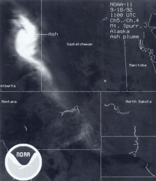 |
Figure 11. Image from the NOAA-11 polar-orbiting weather satellite on 18 November at 0300 Alaska Daylight Time, showing the 16-17 September ash cloud over E Alberta, SW Saskatchewan, and E Montana. A band 5/band 4 ratio was used to enhance the ash cloud. Courtesy of G. Stephens. |
Seismicity declined slowly after the September eruptive episode, but deep earthquakes continued to occur. SO2 flux measured by COSPEC rose from about 300 metric tons/day (t/d) on 25 September to 800 t/d on 29 September. Shallow seismicity began to increase again on 30 September, and weak volcanic tremor resumed on 1 October at 1900, the first tremor recorded since 25 September. Tremor amplitude increased on 2 October to levels comparable to those preceding the June and September eruptive episodes, but sustained tremor ended abruptly at 1830 that evening. Intermittent, banded tremor alternated with periods of sustained tremor during the next several days, while fieldwork revealed continued emission of a roughly 1-km white plume from the S flank's Crater Peak vent. CO2 flux had declined from nearly 10,000 t/d in late September to 2,900 t/d on 5 October, while the rate of SO2 emission had steadied at about 400 t/d. Tremor stopped before noon on 6 October but periodic low-amplitude tremor resumed on the 8th. Tremor stopped again on 10 October but resumed on the 15th, as a few shallow and deep earthquakes were recorded daily. Intermittent tremor continued as of 20 October.
Geological Summary. Mount Spurr is the closest volcano to Anchorage, Alaska (130 km W) and just NE of Chakachamna Lake. The summit is a large lava dome at the center of a roughly 5-km-wide amphitheater open to the south formed by a late-Pleistocene or early Holocene debris avalanche and associated pyroclastic flows that destroyed an older edifice. The debris avalanche traveled more than 25 km SE, and the resulting deposit contains blocks as large as 100 m in diameter. Several ice-carved post-collapse cones or lava domes are present. The youngest vent, Crater Peak, formed at the southern end of the amphitheater and has been the source of about 40 identified Holocene tephra layers. Eruptions from Crater Peak in 1953 and 1992 deposited ash in Anchorage.
Information Contacts: AVO; G. Stephens, NOAA/NESDIS.