Report on Manam (Papua New Guinea) — November 1992

Bulletin of the Global Volcanism Network, vol. 17, no. 11 (November 1992)
Managing Editor: Lindsay McClelland.
Manam (Papua New Guinea) Strong explosions; pyroclastic flows; lava flows to sea
Please cite this report as:
Global Volcanism Program, 1992. Report on Manam (Papua New Guinea) (McClelland, L., ed.). Bulletin of the Global Volcanism Network, 17:11. Smithsonian Institution. https://doi.org/10.5479/si.GVP.BGVN199211-251020
Manam
Papua New Guinea
4.08°S, 145.037°E; summit elev. 1807 m
All times are local (unless otherwise noted)
"Manam continued erupting during November, with a paroxysmal phase from Main Crater on the 5th-6th. Towards the end of October and in early November, Main Crater's emission column showed a progressive reduction in size from several kilometres to <1 km. On 3 and 4 November, white to pale-grey emissions with very low ash contents were seen. In inverse correlation with the reduction in eruption column size, seismic activity showed a steady increase.
"The increasing seismicity heralded a new phase of strong activity at Main Crater. A rapid intensification of Main Crater activity began about 1800 on 5 November, with strong emission of thick ash clouds. The ash column reportedly rose to ~7 km. Moderate-heavy ash and scoria fall occurred on the downwind (W) flank of Manam. Small pyroclastic flows were generated early in this phase, descending the NE valley and terminating 2-3 km from the coast. A lava flow succeeded the pyroclastic flows and reached the coast (5 km distance) at about midnight (figure 6). The lava advanced through part of a village on the S side of NE Valley, obliterating 14 houses and a number of food gardens. This lava flow was reportedly the fastest-moving of all of the flows produced during Manam's 1992 eruption. It had stopped moving at the coast by about 0300 on 6 November. There seems to have been a complex interplay between lava effusion and the generation of pyroclastic flows, as parts of the lava flow were overridden by pyroclastic flows produced during and after the effusive phase. These pyroclastic flows were unlike earlier ones in that they contained significant amounts of accessory lithics. Some of these blocks are as much as 8 m across. One very large block moved down the valley, leaving a trail of striations. A portion of this lithic material could have been vent-derived, but there is clear evidence that some of it was eroded from the lava flows flanking the crater.
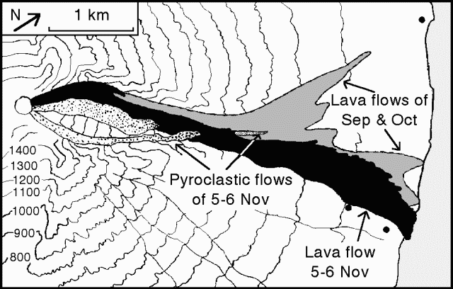 |
Figure 6. Sketch map of the September-October 1992 lava flows at Manam, and the lava flow and pyroclastic-flow desposits of 5-6 November in NE Valley, all from Main Crater. The NW Valley deposits, Southern Crater, and its deposits in SW and SE Valleys are not shown. Note that north is to the upper right. Courtesy of RVO. |
"A second pulse of strong explosive activity from Main Crater took place early on 6 November. This activity was somewhat unusual in that it generated pyroclastic flows which, for the first time in this eruption, were directed over the high back-wall of the crater into the NW valley. These are the first pyroclastic flows to be emplaced in NW Valley since the very strong eruption of 1958. Unlike the flows erupted into NE Valley on 5 November, the NW Valley flows consisted almost entirely of vesiculated juvenile material. These flows were as much as 60 m wide and 5 m thick. At one point, ~550 m asl, where a flow had bifurcated into two parallel drainages, thin surge deposits (~10 cm total thickness) were found along the separating ridge. Where the main body of the flow had cascaded down a dry waterfall in the main drainage channel, arcuate pressure ridges had been formed. The terminus of the NW Valley pyroclastic-flow deposits is ~320 m asl, ~3.5 km from the summit.
"The strong eruptive phase had ended by about 0600 on 6 November. Seismic activity showed a good correlation with visible activity, peaking late at night on 5 November, then showing a subsidiary peak at about 0200 on 6 November. Seismic activity had reached a low level by 0800 on the 6th. Ash was still being emitted from Main Crater, however, and formed a column ~1 km high at 0900. Southern Crater was not involved in this activity and continued to gently release small amounts of white vapour.
"There were no additional strong eruptive phases at Main Crater through the remainder of the month. Ash and vapour continued to be emitted, forming a column up to ~1 km high for most of this period, although rarely the column was as much as 2 km high. Light ashfalls were reported in coastal areas downwind. Weak-to-bright glow from both craters was seen on most nights and small ejections of incandescent lava fragments were occasionally observed. At Southern Crater the emissions consisted of white and blue vapours in small-to-moderate volumes.
"Seismic activity following the eruption of 5-6 November was at a low level until the 14th, when it again began to increase. Seismicity stabilized at a moderate level on the 18th, then began declining on the 25th. At the end of the month, seismicity was stable at a low level.
"Aerial inspections of the summit showed that Main Crater is a shallow funnel-shaped structure with a high wall on its W side. Numerous fumaroles are present in the partial somma around the S side of the vent. Southern Crater is a smaller structure than Main Crater - topographic details were mostly obscured by emissions."
Geological Summary. The 10-km-wide island of Manam, lying 13 km off the northern coast of mainland Papua New Guinea, is one of the country's most active volcanoes. Four large radial valleys extend from the unvegetated summit of the conical basaltic-andesitic stratovolcano to its lower flanks. These valleys channel lava flows and pyroclastic avalanches that have sometimes reached the coast. Five small satellitic centers are located near the island's shoreline on the northern, southern, and western sides. Two summit craters are present; both are active, although most observed eruptions have originated from the southern crater, concentrating eruptive products during much of the past century into the SE valley. Frequent eruptions, typically of mild-to-moderate scale, have been recorded since 1616. Occasional larger eruptions have produced pyroclastic flows and lava flows that reached flat-lying coastal areas and entered the sea, sometimes impacting populated areas.
Information Contacts: C. McKee, RVO.