Report on Platanar (Costa Rica) — January 1993
Bulletin of the Global Volcanism Network, vol. 18, no. 1 (January 1993)
Managing Editor: Lindsay McClelland.
Platanar (Costa Rica) No significant deformation since 1987
Please cite this report as:
Global Volcanism Program, 1993. Report on Platanar (Costa Rica) (McClelland, L., ed.). Bulletin of the Global Volcanism Network, 18:1. Smithsonian Institution. https://doi.org/10.5479/si.GVP.BGVN199301-345034
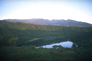
Platanar
Costa Rica
10.3°N, 84.366°W; summit elev. 2267 m
All times are local (unless otherwise noted)
Dry-tilt data have shown no significant changes since 1987.
Geological Summary. The Platanar volcanic center is the NW-most volcano in the Cordillera Central of Costa Rica. The massive complex covers about 900 km2 and is dominated by two largely Pleistocene stratovolcanoes, Platanar and Porvenir. These volcanoes were constructed within the Pleistocene Chocosuela caldera, which may have formed during a major slope failure. The Cerro Platanar volcano (known locally as Volcán Congo) on the N side of the complex has prehistorical lava flows on its W flanks and is the youngest volcanic center. The highest peak is Porvenir, whose summit crater lies 3 km S of Platanar. A thin layer of phreatic ash suggested that an eruption from Platanar occurred within the past few thousand years (Stine and Banks, 1991). The Aguas Zarcas group of nine basaltic cinder cones, located on the N flank of the Platanar-Porvenir complex to as low as 160 m altitude is, in part, Holocene in age.
Information Contacts: E. Fernández, J. Barquero, R. Van der Laat, F. de Obadía, T. Marino, and R. Sáenz, OVSICORI; M. Martini, Univ di Firenze, Italy.