Report on Erta Ale (Ethiopia) — July 1993
Bulletin of the Global Volcanism Network, vol. 18, no. 7 (July 1993)
Managing Editor: Edward Venzke.
Erta Ale (Ethiopia) Review of satellite data reveals lava lake activity in June 1992
Please cite this report as:
Global Volcanism Program, 1993. Report on Erta Ale (Ethiopia) (Venzke, E., ed.). Bulletin of the Global Volcanism Network, 18:7. Smithsonian Institution. https://doi.org/10.5479/si.GVP.BGVN199307-221080
Erta Ale
Ethiopia
13.601°N, 40.666°E; summit elev. 585 m
All times are local (unless otherwise noted)
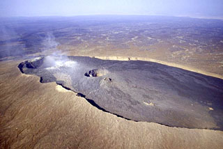
"The visit . . . on 10-11 November 1992 showed that since the last recorded observation, made using Landsat TM data from 9 February 1987, the lava lake in the N crater had disappeared (presumably frozen over and collapsed), but that the lava lake in the S crater . . . was still active. This interpretation is consistent with visual observations made during an aircraft overflight on 21 September 1992 (17:8-9).
"New satellite data further narrow the window of uncertainty about when the N lava lake became inactive, and provide evidence of the continuity of activity at the S lava lake. Data from the Japanese Earth Resources Satellite-1 (JERS-1, also known as Fuyo-1) recorded on 9 June 1992 show the S lava lake to be a strong source of short-wavelength infrared radiation, which is convincing evidence that it was active. However, there is no trace of any short-wavelength infrared thermal radiance from the N lava lake, indicating that the lake had already ceased to exist.
"JERS-1 was launched on 11 February 1992. Its optical sensors record images in three visible channels, and (more importantly for thermal remote sensing of volcanoes) in four short-wavelength infrared channels: 1.55-1.77, 2.01-2.12, 2.13-2.25, and 2.27-2.40 µm. The image pixels are 18 m across. This contrasts with Landsat TM which has 30 m pixels in two short-wavelength infrared channels (1.55-1.75 and 2.08-2.35 µm). This is believed to be the first demonstration that JERS-1 data can play a useful role in volcano monitoring. The thermal anomaly covers an approximately equidimensional area 4-5 pixels across in all four short-wavelength infrared channels, which is roughly consistent with the size of the lava lake seen during fieldwork five months later."
Geological Summary. The Erta Ale basaltic shield volcano in Ethiopia has a 50-km-wide edifice that rises more than 600 m from below sea level in the Danakil depression. The volcano includes a 0.7 x 1.6 km summit crater hosting steep-sided pit craters. Another larger 1.8 x 3.1 km wide depression elongated parallel to the trend of the Erta Ale range is located SE of the summit and is bounded by curvilinear fault scarps on the SE side. Basaltic lava flows from these fissures have poured into the caldera and locally overflowed its rim. The summit caldera usually also holds at least one long-term lava lake that has been active since at least 1967, and possibly since 1906. Recent fissure eruptions have occurred on the N flank.
Information Contacts: D. Rothery, Open Univ.