Report on Arenal (Costa Rica) — July 1993

Bulletin of the Global Volcanism Network, vol. 18, no. 7 (July 1993)
Managing Editor: Edward Venzke.
Arenal (Costa Rica) Lava flows remain active; explosions and pyroclastic-flow activity decrease
Please cite this report as:
Global Volcanism Program, 1993. Report on Arenal (Costa Rica) (Venzke, E., ed.). Bulletin of the Global Volcanism Network, 18:7. Smithsonian Institution. https://doi.org/10.5479/si.GVP.BGVN199307-345033
Arenal
Costa Rica
10.463°N, 84.703°W; summit elev. 1670 m
All times are local (unless otherwise noted)
Gas emissions and lava flows continued at Crater C in July, as well as sporadic Strombolian activity that sent ash columns >500 m above the crater rim. Explosions have decreased in quantity and magnitude compared to June. The lava flow that started in mid-April on the SW flank remained active as its W lobe descended another 50 m to 1,150 m elevation and the SW lobe traveled 150 m down to 1,100 m. A new lobe from this flow that formed in early July descended to the SW. A new lava flow was also observed on 20 July moving WNW. At 1022 on 21 July a rock avalanche traveled NW to 1,300 m elevation. Another avalanche was observed later that day at 1100, and seven more occurred from 1314 and 1355. The lowest elevation reached by the fronts of these nine avalanches was 1,150 m.
Three distance lines continued to show minor contraction in 1993. The last measurement was made on 21 July. The radial leveling line on the W flank indicated deflation of 8.9 µrad between 26 August 1992 and 21 July 1993. Deformation measured at most dry-tilt stations was insignificant. However, three stations on the SW and W flanks exhibited cumulative inflation of ~10 µrad since 15 April. The seismic station 2.7 km NE of the active crater (VACR) registered 651 events in July, with the highest daily total on 21 July. Most of the seismicity was associated with ash eruptions and pyroclastic activity. The level of explosive activity was less in June and July than earlier in the year. Tremor averaged 13 hours/day, with the highest daily total of 23 hours recorded on 8 July. There was more tremor in July than in any previous month this year.
The following report, of activity from 25 July to 4 August, is from W. Melson (SI), and V. Barboza and Jorge Barquero (OVSICORI). "Arenal showed an extremely low level of pyroclastic activity during this period, the lowest recorded during regular periods of observations by Smithsonian Institution volunteers since 1987. There have been 18 such observation periods, each lasting about 10 days for 24-hours/day, from the Arenal Observatory Lodge about 2.8 km S of the summit (figure 59). Periods of high tremor were common. Ongoing 3-component seismic measurements have shown that tremor produces weak vertical signals but strong horizontal signals (figure 60). The dominance of horizontal over vertical motion has been characteristic of Arenal's seismicity over the past 3 years. Local observers reported that a large fragment of the WNW rim collapsed around 19 or 20 July, forming a notch through which lava continued to move as of 4 August. The lava flow was moving slowly (~10-30 m/day) down the WNW slope, and had reached ~1,100 m elevation below the new cone being built to an approximate elevation of 1,650 m above old Crater C."
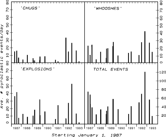 |
Figure 59. Summary of pyroclastic-flow activity at Arenal since 1987 during 18 approximately 10-day periods of 24-hours/day observations from the Arenal Observatory Lodge, 2.8 km S of the summit, made by Earthwatch and Smithsonian Institution volunteer expeditions. "Chug" and "whoosh" events are characterized by their sound. Courtesy of W. Melson. |
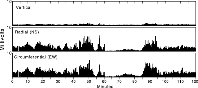 |
Figure 60. Tremor levels at Arenal during a 2-hour period on 25 July 1993. Values are averaged over 21.5-second intervals and calculated as equal to the sum of the absolute values of signals in decimillivolts divided by number of counts/21.5 seconds at an AD conversion rate of about 100 counts/second. A Mark L-4C 3D seismometer was used with a 16 bit AD board. Courtesy of W. Melson. |
Geological Summary. Conical Volcán Arenal is the youngest stratovolcano in Costa Rica and one of its most active. The 1670-m-high andesitic volcano towers above the eastern shores of Lake Arenal, which has been enlarged by a hydroelectric project. Arenal lies along a volcanic chain that has migrated to the NW from the late-Pleistocene Los Perdidos lava domes through the Pleistocene-to-Holocene Chato volcano, which contains a 500-m-wide, lake-filled summit crater. The earliest known eruptions of Arenal took place about 7000 years ago, and it was active concurrently with Cerro Chato until the activity of Chato ended about 3500 years ago. Growth of Arenal has been characterized by periodic major explosive eruptions at several-hundred-year intervals and periods of lava effusion that armor the cone. An eruptive period that began with a major explosive eruption in 1968 ended in December 2010; continuous explosive activity accompanied by slow lava effusion and the occasional emission of pyroclastic flows characterized the eruption from vents at the summit and on the upper western flank.
Information Contacts: E. Fernández, J. Barquero, R. Van der Laat, F. de Obaldia, T. Marino, V. Barboza, and R. Sáenz, OVSICORI; W. Melson, SI.