Report on Pinatubo (Philippines) — August 1993

Bulletin of the Global Volcanism Network, vol. 18, no. 8 (August 1993)
Managing Editor: Edward Venzke.
Pinatubo (Philippines) Rainy season causes renewed lahar activity and secondary explosions
Please cite this report as:
Global Volcanism Program, 1993. Report on Pinatubo (Philippines) (Venzke, E., ed.). Bulletin of the Global Volcanism Network, 18:8. Smithsonian Institution. https://doi.org/10.5479/si.GVP.BGVN199308-273083
Pinatubo
Philippines
15.13°N, 120.35°E; summit elev. 1486 m
All times are local (unless otherwise noted)
Another monsoon season, with the renewed threat of secondary explosions and lahars from the slopes of Mt. Pinatubo, began in early June. Secondary explosions occur when rainwater percolates into hot deposits of ash and pyroclastic materials from the 1991 eruption; the rainfall and explosions often trigger lahars. Five major river drainages (figure 30) served as channels for lahars during the 1993 rainy season: O'Donnell-Tarlac (NNE), Sacobia-Bamban (NE), Pasig-Potrero (SE), Marella-Santo Tomas (SW), and Bucao-Balin Baquero (NW). No lahars flowed down the Abacan River (E) because it has remained cut off from the pyroclastic-flow source. Based on flow sensor records, the most active channels during this rainy season were the Sacobia-Bamban and the Bucao-Balin Baquero rivers, each with 26 lahars. The O'Donnell, Pasig-Potrero, and Marella-Santo Tomas rivers had 18, 15, and 14 lahar events, respectively.
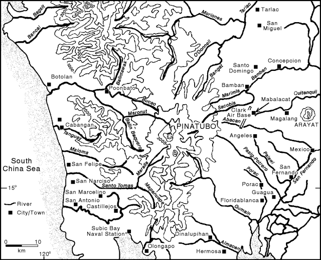 |
Figure 30. Map of Pinatubo and the surrounding area showing approximate locations of selected towns and rivers prior to the June 1991 eruption. Mapanuepe Lake has since replaced the Mapanuepe River. |
A thunderstorm on 5 June caused a secondary phreatic explosion that generated an ash plume to a height of about 1,500 m. Another storm on 7 June caused an explosion, and some sediment was observed in the Sacobia River. However, neither storm triggered significant mobilization of debris. On 26 June, typhoon-generated lahars along the Marella-Santo Tomas River caused 1-5 m of aggradation along some portions of the channel and buried parts of 3 barangays (communities) in San Marcelino (about 30 km SW of the summit) with 10-30 cm of debris. These moderate lahars on the W slope prompted precautionary evacuations in late June. Areas in Pampanga and Tarlac provinces were also evacuated because of flooding along the Sacobia River, which has been filled with lahar deposits over the past 2 years.
On 2 July, intense local rainshowers triggered lahars to the NE along the Sacobia-Bamban River, causing lateral erosion along villages N of the Clark Air Base perimeter fence, and destroying several houses. Farther downstream, 1-m-high dilute lahars deposited 50 cm of debris at a barangay 3 km E of Mabalacat. Along the Pasig-Potrero river (SE), the lahars were mostly channel-confined until escaping through an unfinished portion of the S dike (because of a right-of-way problem with the landowners) into the N barangays of Santa Rita, 5 km NW of Guagua and 9 km WSW of San Fernando, causing burial of some areas.
Lahar events during the first half of August were mostly small. Larger and almost continuous flows, triggered by SW monsoon rains, occurred on 18-19 August along the five major channels. Monsoonal rains also triggered significant flooding in low-lying areas around Pinatubo. On the SE flank along the Pasig-Potrero River, several barangays were affected when initially channel-confined lahars overtopped 3-4 m dikes. Lahars escaped at the N bank near the site of the former Mancatian Bridge in Porac and buried some parts of a barangay. The flow then overtopped the S bank, passed along a tributary, and buried areas on the S side of Mancatian (~8 km SW of Angeles) under 2-m-thick deposits. Lahars continued to flow into Santa Rita barangays, 9-11 km downstream of Mancatian; these had also been affected by lahars in 1992.
Along the Sacobia-Bamban River on the NE slopes, the 18-19 August lahars caused 100 m of lateral erosion along the S bank at Marcos and Macapagal villages. Lahars to the NNE along the O'Donnel-Tarlac River were channel-confined and left deposits near the upper reaches before entering inhabited areas. On the SW side of Pinatubo, along the Marella-Santo Tomas River, the 18-19 August lahars caused 3-4 m of aggradation along some parts of the channel and buried a barangay in San Marcelino located on the S bank, inside the protective dike built before the start of the rainy season. Lahars also breached a 1.5 km section of the dike near San Rafael (5 km E of San Marcelino) and buried the Western Luzon Agricultural College site with 0.5-1.5 m of debris. The breached portion became a passageway for a significant volume of water from Mapanuepe Lake. As a result, parts of San Marcelino, Castillejos, and San Antonio were flooded for several days. The floodwaters also destroyed a highway bridge between Castillejos and San Marcelino. Along the Bucao River (NW), lahars were channel-confined and dumped debris far from inhabited areas.
Secondary explosions from hot debris deposits sent ash to about 15 km altitude at about 1210 on 19 August and prompted Significant Meteorological Event (SIGMET) warnings to aircraft in the vicinity. A cold plume was detected on satellite imagery near the volcano at 1331. It drifted SSW through 1631 when it became indistinguishable from the large cloud canopy of a tropical storm.
The Zambales Lahar Scientific Monitoring Group noted that the 18-19 August lahars along the Marella-Santo Tomas and Bucao-Balin Baquero river systems have created at least partial isolation for all Zambales towns because of the destruction of highway bridges, and that additional bridge failures must be anticipated. In SW Zambales, the damage was severe and the full extent of the consequences is unknown. As of 21 August, heavy outflow from the lahar-dammed Mapaneuepe Lake was pouring from a major breach in a dike along the S margin of the Santo Tomas River, causing serious problems for the towns of San Marcelino, San Antonio, and to a lesser degree, Castillejos. The very small but significant relief of terrain downstream of the breached dike makes hazard assessment very difficult; irrigation ditches may be invaded, becoming efficient lahar channels, and small roads built above the plain could fail and cause sudden shifts in flow directions.
Based on a report by the Regional Disaster Coordinating Council of Central Luzon, 97 houses were destroyed and 43 houses were damaged by the 18-19 August lahar events in the Pampanga province, mostly in the barangays of Porac near the Pasig-Potrero River, though residents had been evacuated prior to the lahars. In the province of Zambales, 575 houses were destroyed and another 372 damaged. Most of this damage was caused by lahars and floods along the Santo Tomas River system. Four deaths from the flooding were reported. Lahars during the second half of August and first half of September were mostly small and channel-confined. A Notice to Airmen (NOTAM) was issued on 25 August advising pilots to expect secondary explosions and avoid overflights of the volcano when they are occurring. Lahars on 29-30 August along the Sacobia-Bamban River (NE) deposited 50 cm of debris in barangay Sapang Balen, ~4 km SE of Bamban. A Volcanic Ash Advisory was issued from Australia on 5 September that referred to a secondary explosion at about 1330 that sent a plume above 3 km. Satellite imagery showed a possible small plume at about that time which tracked SW before being hidden in weather clouds after 1830. An 11 September lahar along the Pasig-Potrero River again affected a barangay in Santa Rita.
Geological Summary. Prior to 1991 Pinatubo volcano was a relatively unknown, heavily forested lava dome complex located 100 km NW of Manila with no records of historical eruptions. The 1991 eruption, one of the world's largest of the 20th century, ejected massive amounts of tephra and produced voluminous pyroclastic flows, forming a small, 2.5-km-wide summit caldera whose floor is now covered by a lake. Caldera formation lowered the height of the summit by more than 300 m. Although the eruption caused hundreds of fatalities and major damage with severe social and economic impact, successful monitoring efforts greatly reduced the number of fatalities. Widespread lahars that redistributed products of the 1991 eruption have continued to cause severe disruption. Previous major eruptive periods, interrupted by lengthy quiescent periods, have produced pyroclastic flows and lahars that were even more extensive than in 1991.
Information Contacts: Philippine Institute of Volcanology and Seismology, Philippines; R. Alonso, K. Rodolfo, and R. Tamayo, Zambales Lahar Scientific Monitoring Group, a cooperative effort of: Univ of Illinois at Chicago Dept of Geological Sciences, Philippine Dept of Environmental & Natural Resources, and the Univ of the Philippines National Institute of Geological Sciences, ZLSMG Headquarters, M6, Subic Bay Free Port, c/o Mayors Office, Olongapo, Philippines; Jim Lynch, SAB; U.S. Embassy, Manila; AP.