Report on Ol Doinyo Lengai (Tanzania) — September 1993

Bulletin of the Global Volcanism Network, vol. 18, no. 9 (September 1993)
Managing Editor: Edward Venzke.
Ol Doinyo Lengai (Tanzania) Carbonatitic lava production continues, but at lower levels than in June
Please cite this report as:
Global Volcanism Program, 1993. Report on Ol Doinyo Lengai (Tanzania) (Venzke, E., ed.). Bulletin of the Global Volcanism Network, 18:9. Smithsonian Institution. https://doi.org/10.5479/si.GVP.BGVN199309-222120
Ol Doinyo Lengai
Tanzania
2.764°S, 35.914°E; summit elev. 2962 m
All times are local (unless otherwise noted)
By 3 July activity had declined, but the surge of emissions had resulted in most of the crater floor being covered with pahoehoe flows in the N and blocky aa flows in the S. New vents in the S part of the crater were the source of most of the carbonatitic lava flows, which elevated the S floor higher than cone T14 in the N. No reports were received of activity between 3 July and 10 September. The following report describes visits to the summit crater . . . on 10 and 25 September 1993. The 10 September observations were made by Ben Kneller and Cindy Ebinger (Leeds Univ), who ascended to the NE crater rim in the morning, accompanied by Jumanne Juma and Felix John (Dorobo Safaris Ltd.), and remained in the crater for ~5 hours. Observations from 25 September were reported by Abigail Church (British Museum of Natural History), who spent 4 hours in the summit area that morning.
The only activity observed on 10 September was fumarolic, although deep booming sounds were heard coming from shallow depths beneath the crater floor at ~10-15 minute intervals, causing the crater floor to occasionally tremble slightly. Vegetation on the upper slopes outside the crater was scorched and brown, but some plants showed renewed growth. An ash deposit a few centimeters thick around the W rim was presumed to be a result of mid-June activity.
The N half of the crater was still covered with smooth white carbonatitic pahoehoe flows on 10 September (figure 31), with cones T20 and T5/T9 rising ~20 m above the surface of the flows. A very recent flow on the extreme W part of the crater floor extended N from centers immediately N of the blocky lava front, where three hornitos 10-30 cm high were present. The lava was pale chocolate-brown in color, and very hot to the touch (70-80°C). The area under the NW crater rim was occupied by slightly older lavas from the same centers, which had flowed around the apron of lava from T20. A small inactive cone E of the fresh pahoehoe flows along the W side of the crater may have been T22, not observed on 29 June. A number of small pahoehoe flows had apparently erupted through the blocky lavas from several centers near T5/T9 and in the vicinity of T24, building a small (40 cm) hornito. Small amounts of gas were venting through holes and fissures in the area around T5/T9 and near the W crater wall close to the source of the most recent lava flow, producing patches of alteration, often with brightly colored sublimates.
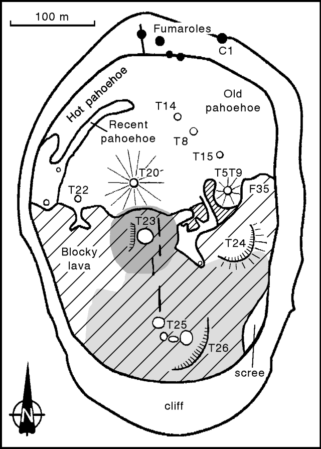 |
Figure 31. Sketch map of Ol Doinyo Lengai crater, 10 September 1993. Hatched area indicates elevated blocky lava flows (finer hatching is older clinkery flow), open circles are cones, and solid circles are fumaroles. Dark shading indicates recent dark ash from T23; light shading indicates area covered by older ash. Constructed by triangulation using photographs taken from three points on the N and W crater rim. Courtesy of Ben Kneller. |
. . . cone T23 was the source of much of the lava in the N part of the crater, and was continuously venting a large quantity of hot gas. T23 consisted of a 2-3-m-high, broad cinder cone of black tephra (proximally up to 30 cm long) with the W side of the partially collapsed cone forming a low, W-facing scarp. Large black lapilli (probably from T23) overlay ash from the other cinder cones, and isolated blocks rested on pahoehoe flows. This was the most recently active vent; the booming noises seemed to emanate from beneath T23, and ground motions were more noticeable in its vicinity.
The S part of the crater was occupied by at least three blocky carbonatitic flows, all in existence by 29 June, that were largely covered by tephra from a group of four new cinder cones at T25, and from a new cone at the site of T23. The oldest of these flows, exposed in a small area around T5/T9, was a clinkery flow of centimeter- to decimeter-scale blocks. A flow front ~1 m high (or composite of several flows) of blocky lava with decimeter-scale blocks, that probably originated in the area of T25, occupied much of the S part of the crater floor on the W side. A flow on the far E side of the crater floor (F35) was probably the youngest blocky flow (4-5 m thick), composed of blocks up to several meters in size, and may have originated from a breached cone (T24) near the E crater wall. T24 had an arcuate NW-facing scarp rising ~5 m above the lava surface.
The T25 cinder cones formed a slightly arcuate group rising 6-7 m above the lava; two had 10-m-deep central pits. All of the cones were cold, with the exception of one that was venting small amounts of hot gas (probably H2S and CO2 based on the odor and the absence of condensed water vapor). Material presumed to be from the T25 cones was scoriaceous, dominantly sand-sized ash, with some larger lapilli. Maximum and mean grain size increased towards the T25 cones; blocks around the cones were up to 50 cm across. The ash was loose and white on the surface, but just a few centimeters below the surface it was black in color and felt warm to the touch. These deposits were older than the pahoehoe lavas between T23 and T5/T9. A shallow excavation W of T23 revealed that blocky lava was overlain by four layers of tephra; ash was succeeded by lapilli (10-15 cm), more ash, then a surface layer of lapilli. Fissures had opened in the ash and underlying lava after deposition of the ash. Cone T26 was breached with a NW-facing scarp rising ~10 m above the lava surface.
A small cloud of black ash ejected from the crater on 24 September was blown W, with ash being deposited on the W and N slopes. Sulfur odor was detected on the lower flanks of the volcano the next morning. Figure 32 shows the 15 June blocky lava flow (18:07), which originated from a large, newly formed 20-m-diameter depression just above the two buttes along the W trail to the rim. The lava flow was ~70 m long and up to 2.5 m thick. There were many fumaroles in the area of the new depression, and surrounding vegetation was burned and covered with fine ash. A large landslide along the NW crater wall just N of the buttes was also seen. It is not known when the landslide occurred, but observers from the British Museum of Natural History noted in September 1992 that the crater wall in that area was particularly weak (17:09).
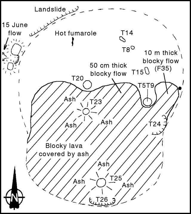 |
Figure 32. Sketch map of the active crater of Ol Doinyo Lengai, 25 September 1993. Hatched area indicates elevated blocky lava flows, open circles are cones, and solid circle is a fumarole. Maximum E-W diameter is ~300 m; maximum height of crater wall is 8-10 m (NW rim). Courtesy of A. Church. |
There were no lava or ash eruptions during the 25 September visit, but a deep rumbling sound was heard about once every hour. On the N part of the crater floor, covered by old gray pahoehoe flows, vents T20 and T5/T9 remained inactive, and sulfur staining was seen on the visible portions of T8, T14, and T15. In contrast, the elevated S crater floor remained covered either by new ash or aa flows. In the center of the crater, the T23 ash cone had grown so its vent opening was ~5 m in diameter and 3 m deep. A constant shimmer was observed above T23 during the visit; this vent may have been the source of a 50-cm-thick aa flow between T20 and T5/T9. The most recently erupted material, an ash/lapilli deposit, covered most of the blocky material near T23 as well as the vent itself. At the S end of the crater, T25 was a nearly perfect ash cone with a basal diameter of ~10 m, rising ~15 m above the surrounding lava. Numerous bombs up to 20 cm in diameter were present around the base of T25 and on the ground to the N and NE. They consisted of a friable white outer crust ~5 mm thick, and a dark, vesicular interior. Just S of T25, the 45-m-wide T26 vent had collapsed, revealing layers of spatter and ash that made up its walls.
Mineralogical investigations of the blocky flow in the E part of the crater (F35) revealed that it consists of alkali carbonates with a small but constant proportion of silicates. This is the first documented association of these minerals since 1966, when explosive ash eruptions lasted for several months and produced a deep pit crater. These observations suggest that the recent increase in activity . . . may be related to a change in magma chemistry.
Fumaroles on the N rim were especially active on 10 September, with many open fissures tangential to the rim. Four small vents were located on the inner crater wall W of C1, of which the westernmost was associated with an open radial fissure up to 3 m wide. Lava on the nearby crater floor was very altered. Temperature measurements of fumaroles on the crater floor were taken on 25 September using NiCr-NiAl thermocouples. The maximum temperature of 167.0°C was obtained from a very active fumarole near the approximate site of vent T21 (only observed on 8 June; 18:07). Fumaroles on the crater wall near T24 had a temperature of 68.0°C. Away from the fumaroles, the average temperature of the crater floor was 37.4°C.
Based on an interview of Philip Sarayan, a resident of Ngare Sero, Church states that earthquakes in late April appear to have been associated with large "cracks" that opened in the ground between Lake Manyara (100 km S) and Lake Natron (200 km N). Sarayan was told by a local Maasai herdsman that a cow had been lost down one of the cracks, and also reported that a circular hole 50 m in diameter and 10 m deep formed ~15 km N of the volcano following a small tremor on 25 April.
Geological Summary. The symmetrical Ol Doinyo Lengai is the only volcano known to have erupted carbonatite tephras and lavas in historical time. The prominent stratovolcano, known to the Maasai as "The Mountain of God," rises abruptly above the broad plain south of Lake Natron in the Gregory Rift Valley. The cone-building stage ended about 15,000 years ago and was followed by periodic ejection of natrocarbonatitic and nephelinite tephra during the Holocene. Historical eruptions have consisted of smaller tephra ejections and emission of numerous natrocarbonatitic lava flows on the floor of the summit crater and occasionally down the upper flanks. The depth and morphology of the northern crater have changed dramatically during the course of historical eruptions, ranging from steep crater walls about 200 m deep in the mid-20th century to shallow platforms mostly filling the crater. Long-term lava effusion in the summit crater beginning in 1983 had by the turn of the century mostly filled the northern crater; by late 1998 lava had begun overflowing the crater rim.
Information Contacts: B. Kneller and C. Ebinger, Univ of Leeds; A. Church, Natural History Museum, London.