Report on Santa Maria (Guatemala) — November 1993

Bulletin of the Global Volcanism Network, vol. 18, no. 11 (November 1993)
Managing Editor: Richard Wunderman.
Santa Maria (Guatemala) Lava effusion and frequent explosions
Please cite this report as:
Global Volcanism Program, 1993. Report on Santa Maria (Guatemala) (Wunderman, R., ed.). Bulletin of the Global Volcanism Network, 18:11. Smithsonian Institution. https://doi.org/10.5479/si.GVP.BGVN199311-342030
Santa Maria
Guatemala
14.757°N, 91.552°W; summit elev. 3745 m
All times are local (unless otherwise noted)
Frequent phreatic to phreatomagmatic explosions and lava effusion from the currently active Caliente vent immediately SE of the breached summit crater have continued at a less vigorous level than during 1988-91. During the Santa María Decade Volcano Workshop in Quetzaltenango, 7-13 November 1993, activity was observed on several days from the old "Hotel Magermann" site to the NW, from the summit of Santa María, from the Santiaguito Volcano Observatory and from other locations to the S. Participants observed brief explosions from the Caliente vent at intervals ranging from less than a minute to tens of minutes apart. The explosions, less vigorous than during a period of increased activity from 1988-91, ejected white to light-gray convoluting columns of gas and ash to heights of about 100 m to 1 km. Infrequently, larger explosions were accompanied by small pyroclastic flows that traveled several hundred meters, but did not extend beyond the base of the dome.
From the summit of Santa María, three generations of nested craters could be seen at the summit of the Caliente vent (figure 25). The active vent is located immediately below and SE of the Caliente vent complex summit crater, which was breached to the SE by lateral explosions in 1990. A low mound of lava filled the vent and fed lava flows that traveled to the SW, SE, and E. As seen from above, explosions typically began along an approximately 100-m-wide circular arc, apparently defining the upper margin of the vent funnel, and subsequently spread rapidly through the center of the lava mound, vigorously ejecting gas and ash through the highly fractured vent carapace with little noticeable block ejection. Sounds like a jet aircraft continued for up to several minutes after the eruptions.
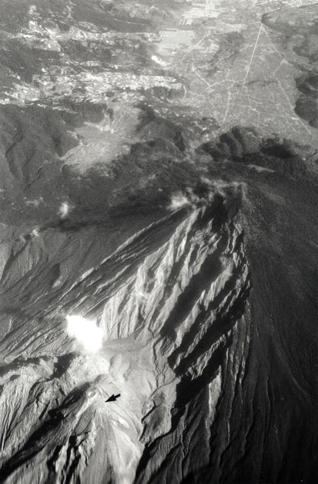 |
Figure 25. Oblique aerial photo of Santa María volcano (3,772 m) from the S, 12 November 1993. The ~2,500 m Santiaguito lava dome complex lies at the lower left, at the base of the extensively gullied 1902 Santa María explosion crater. The currently active Caliente vent (arrow) is located immediately below the circular summit crater of Caliente. The Caliente vent feeds lava flows to the SW, SE, and E. The outskirts of the city of Quetzaltenango lie at the extreme upper right. Photograph by Steve O'Meara. |
By May 1992 the SE lava flow that began in December 1990, following the path of an earlier 1990 lava flow, had intersected the valley wall beneath the SE wall of the 1902 crater and been diverted to the SW along the headwaters of the Río Nimá II. As of November 1993, the lava flow had reached a distance of about 1 km from the vent; occasional hot avalanches from the lava flow reached the base of the dome. A smaller blocky lava flow filled about the upper 300 m of an avalanche channel formed in September on the SW side of Caliente, immediately E of the 1986-88 lava flow, and a third flow extended about 100 m to the E.
Collapse of the SSW side of the crater in September 1993 created the new avalanche channel and produced a pyroclastic flow that divided around a dome buttress immediately below the summit of the Caliente vent. The flows traveled 3 km down the Río Nimá II (figure 26), burning vegetation 100-150 m from the flow margin.
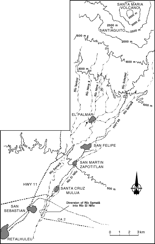 |
Figure 26. Sketch map of rivers and towns S of Santiaguito showing the location of the 28 August 1993 diversion of the Río Samalá into the Río El Niño. Locations of drainages are approximate. The location of the former confluence of the Río Nimá I and Río Nimá II near El Palmar is marked with an arrow. Santiaguito Volcano Observatory is delineated by the circled X. |
The daily frequency of explosions as recorded on seismograms at the Santiaguito Volcano Observatory increased from about 20-60 in July to 60-110 in August (figure 27); data were unavailable for other months. In August, blocks and ash from smaller pyroclastic flows produced by collapse of the lava flow overtopped the ridge above the headwaters of the Río Nimá II SSE of Caliente.
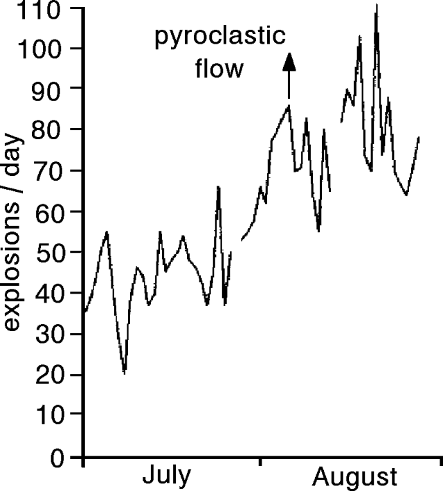 |
Figure 27. Daily number of explosions from Santiaguito July to August 1993. Arrow marks date of pyroclastic flow. Data not available for other months. Courtesy of Otoniel Matías (INSIVUMEH). |
Extensive gullying on the N side of Santiaguito, first reported in February 1990 (15:03), was continuing. El Monje and La Mitad domes were extensively gullied and less-pronounced erosion had affected Caliente and El Brujo domes. Laharic stream deposition below the N flank of El Brujo dome had widened beyond that shown in previous reports (see figure 18). The stream deposition had formed a pond where the aggraded stream channel blocked the Río El Tambor, which originates above the "Hotel Magermann" on the N. The origin of this increase in mass-wasting remains unclear, but the possibility of a weakened dome infrastructure causing partial collapse and stronger explosions continues to be of concern.
Aggradation of the Río Samalá drainage continues to pose problems for areas below Santiaguito. On 28 August, lahars swept down the Río Samalá, nearly overtopping the Carlos-Castillo Armas bridge on the international highway NE of San Sebastián (figure 26), and covering 200 m of the highway E of town. At peak flow, which lasted 2-3 hours, water filled the 6-7-m-deep channel to within 50 cm of the bridge. The lahar raised the bed of the Río Samalá below the bridge, temporarily diverting the river across the highway into the Río El Niño to the E. In November, boulders up to 2.5 m in diameter continued to block one lane of the highway. Lahar deposits were present S of Las Pilas, about 35 km SW of Santiaguito, and thin deposits of hyperconcentrated flows were found nearly to the Pacific coast.
Active downcutting of the Río Nimá II, which now flows in a channel 6-10 m deep, is continuing above the village of El Palmar (figure 26), 10 km S of Santiaguito. Since late 1991, the channel of the Río Nimá II has migrated about 100 m to the W of its previous course within perched levees immediately W of El Palmar, lessening somewhat the risk of capture of the Nimá II by the Río Nimá I and diversion of debris flows into the more populated Río Samalá drainage.
Rainy season lahars in 1992 did not overrun the international highway, but they filled a gorge 15-20 m wide and 40 m deep S of Las Pilas, and destroyed a bridge about 40 km SW of Santiaguito. The 200 residents of Colonia de San Jose Delicias, S of Las Pilas, heard the advancing lahars during the night and evacuated the village. Upon returning in the morning they found their homes buried up to window level.
Geological Summary. Symmetrical, forest-covered Santa María volcano is part of a chain of large stratovolcanoes that rise above the Pacific coastal plain of Guatemala. The sharp-topped, conical profile is cut on the SW flank by a 1.5-km-wide crater. The oval-shaped crater extends from just below the summit to the lower flank, and was formed during a catastrophic eruption in 1902. The renowned Plinian eruption of 1902 that devastated much of SW Guatemala followed a long repose period after construction of the large basaltic andesite stratovolcano. The massive dacitic Santiaguito lava-dome complex has been growing at the base of the 1902 crater since 1922. Compound dome growth at Santiaguito has occurred episodically from four vents, with activity progressing E towards the most recent, Caliente. Dome growth has been accompanied by almost continuous minor explosions, with periodic lava extrusion, larger explosions, pyroclastic flows, and lahars.
Information Contacts: Otoniel Matías, INSIVUMEH; Tom Pierson, USGS; Lee Siebert, SI; Stephen O'Meara, Sky & Telescope, USA.