Report on Manam (Papua New Guinea) — January 1994
Bulletin of the Global Volcanism Network, vol. 19, no. 1 (January 1994)
Managing Editor: Richard Wunderman.
Manam (Papua New Guinea) Short-lived eruption sends ash cloud to 8 km altitude and lava down SE flank
Please cite this report as:
Global Volcanism Program, 1994. Report on Manam (Papua New Guinea) (Wunderman, R., ed.). Bulletin of the Global Volcanism Network, 19:1. Smithsonian Institution. https://doi.org/10.5479/si.GVP.BGVN199401-251020
Manam
Papua New Guinea
4.08°S, 145.037°E; summit elev. 1807 m
All times are local (unless otherwise noted)
"A brief eruption occurred from Southern Crater on 5 January. The intensity was similar to the stronger phases of activity in the prolonged eruption of 1992 and to the brief episodes in July and October 1993. An increase in activity started on 3 January with occasional deep roaring sounds accompanying thin grey emissions and night-time incandescent lava projections as high as 150 m. On 4 January, emissions were of moderate volume and incandescent projections reached 400 m. Simultaneously, there was a progressive increase in seismicity (amplitude, number of events, and tremor).
"The peak of the eruption occurred during the night of 5-6 January, with strong incandescent projections to ~1 km (estimated in cloudy weather conditions), and ash much higher. The pilot of an aircraft passing over the volcano at about 0230 on the 6th reported a lava flow in SE Valley. Another pilot, at 0815, estimated that the ash cloud was rising to 4-8 km asl and drifting SW. Scoria and ash fell on the SSW flank of the volcano. Seismicity during that night reached 9x the usual inter-eruptive background level.
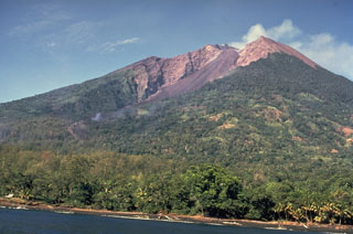
"Lava effusion into SE Valley was voluminous, and the foot of the flow almost reached the coast, ~ 5 km from the summit crater. A small pyroclastic flow descended into SW Valley, but stopped at 750 m elev, ~1 km from the source. The volume of ash emission, and the seismicity, decreased from 6-8 January. Although a weak night glow prevailed for the remainder of the month, emissions from Southern Crater were reduced to weak white vapour release.
"Paradoxically, the eruption occurred after two months of steady deflationary tilting (-3 µrad at the observatory . . .). The eruption itself caused an additional 3 µrad of deflation, but rapid recovery took place throughout the remainder of January. Main Crater activity was unaffected throughout the month, consisting of gentle release of small volumes of white vapour."
A volcanic ash advisory was issued to aircraft following pilot reports on 6 January of ash clouds drifting SW and lava flows. The Bureau of Meteorology in Darwin, Australia, was unable to detect any ash clouds on satellite imagery.
Geological Summary. The 10-km-wide island of Manam, lying 13 km off the northern coast of mainland Papua New Guinea, is one of the country's most active volcanoes. Four large radial valleys extend from the unvegetated summit of the conical basaltic-andesitic stratovolcano to its lower flanks. These valleys channel lava flows and pyroclastic avalanches that have sometimes reached the coast. Five small satellitic centers are located near the island's shoreline on the northern, southern, and western sides. Two summit craters are present; both are active, although most observed eruptions have originated from the southern crater, concentrating eruptive products during much of the past century into the SE valley. Frequent eruptions, typically of mild-to-moderate scale, have been recorded since 1616. Occasional larger eruptions have produced pyroclastic flows and lava flows that reached flat-lying coastal areas and entered the sea, sometimes impacting populated areas.
Information Contacts: D. Lolok and P. de Saint-Ours, RVO; BOM, Darwin.

