Report on Sabancaya (Peru) — March 1994
Bulletin of the Global Volcanism Network, vol. 19, no. 3 (March 1994)
Managing Editor: Richard Wunderman.
Sabancaya (Peru) Moderate Vulcanian activity continues; hazard maps completed
Please cite this report as:
Global Volcanism Program, 1994. Report on Sabancaya (Peru) (Wunderman, R., ed.). Bulletin of the Global Volcanism Network, 19:3. Smithsonian Institution. https://doi.org/10.5479/si.GVP.BGVN199403-354006
Sabancaya
Peru
15.787°S, 71.857°W; summit elev. 5960 m
All times are local (unless otherwise noted)
Fieldwork was conducted on 4-8 March by scientists from the Univ Blaise Pascal (Clermont-Ferrand, France), the Instituto de Geofisico del Perú (Arequipa, Perú), and the Univ de Liège (Belgium). The purpose of the visit was to observe current activity, assess eruptive hazards, and collect samples of juvenile material. The joint mission investigations included the geology and geomorphology of the summit domes and block-lava flows, the role played by explosions on the morphology of the summit, crater, and ice cap (fracturing, gullying, tephra-fall cover, and mudflows), and analysis of tephra, lavas, and ice.
An ash explosion was observed early in the morning on 5 March from Sallili (8 km E at the base of the volcano). The eruption column rose for 30 seconds to a height of 2.5 km and generated a dark gray plume that was blown W. A vapor-rich explosion ~ 2.5 hours later produced a dominantly white plume that rose 1.5 km. Between these explosion there was a discrete vapor plume above the crater. Another early morning explosion on 7 March lasted for about 60 seconds and fed a dark gray plume 1.5 km high. Dominantly white plumes later that morning rose 1-2 km.
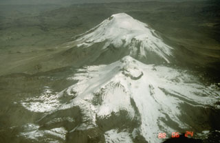
Activity of a similar nature has been exhibited since December 1992, with strong explosions of gas, ash, and blocks forming a gray or light-gray plume rising 1-3 km above the summit. Explosions have occurred every 1-2 hours (20-30 minutes in late 1992), and generally lasted <1 minute. Residents of Sallili have seen glowing projections at night since autumn 1993. Observations in December 1992 (Salas and Thouret) indicated that the crater had widened.
The 1990-92 tephra represent a small bulk volume (0.025 km3), but are widely dispersed around the crater; ballistic blocks reached a few hundred meters, and ash as far as 20 km. The juvenile component belongs to a K-rich calc-alkaline series and is compositionally variable from andesite (58% SiO2) to dacite (63% SiO2). The mineral assemblage of 1990-93 juvenile magma consists of plagioclase, green pyroxene, brown amphibole, biotite, destabilized olivine, and Fe-Ti oxides. Since 1990 the juvenile component has increased from 15 to ~50% by volume. Ejecta consist of black, vitreous, slightly vesicular andesitic fragments and gray dacitic fragments. Glassy black blocks with radial fractures dominate the 1994 tephra. Although the geochemical difference between the andesite and dacite is small, mineralogical disequilibrium suggests an interaction between two magma batches. One was more felsic than the dacite and included oligoclase and hypersthene; the other was more mafic than the andesite and included labradorite, bronzite, and olivine.
Hazard assessment and hazard-zone mapping has been done based on geological and geomorphological data, photo interpretation, remote sensing, and models of tephra dispersion (Thouret and others, 1994). Hazard zones are defined for tephra-fall, pyroclastic flows, lahars, and potential catastrophic events. These zones are portrayed for moderate Vulcanian activity (1990-94), growth of a dome and/or emission of a blocky lava flow, possible increase of Vulcanian activity (including small-scale pyroclastic flows), and a potential large Plinian event. Geological study and remote sensing of the current activity have provided a sound basis for evaluating and mapping hazards at and around Sabancaya. Holocene block-lava flows cover as much as 40 km2 around the summit domes. Thin Plinian tephra-fall deposits from historical eruptions are found as far as 11 km from the crater, and block-and-ash pyroclastic-flow deposits as far as 7 km from the source. Recent lahars have traveled ~25 km downstream.
Unstable lava domes pose a threat for ~35,000 people living in the Rio Colca and Siguas valleys. Sabancaya is still ice-clad (currently estimated to be 3.5 km2 of glacial ice) despite its recent 4-year period of activity. The Majes River irrigation canal project is also at potential risk should a moderate-to-large eruption melt the ice and snow on Sabancaya and Ampato.
Reference. Thouret, J-C., Guillande, R., Huaman, D., Gourgaud, A., Salas, G., and Chorowicz, J., 1994, L'activité actuelle du Nevado Sabancaya (Sud-Pérou): reconnaissance géologique et satellitaire, évaluation et cartographie des menaces volcaniques: Bull. Soc. Geol. France, v. 165, no. 1, p. 49-63.
Geological Summary. Sabancaya, located in the saddle NE of Ampato and SE of Hualca Hualca volcanoes, is the youngest of these volcanic centers and the only one to have erupted in historical time. The oldest of the three, Nevado Hualca Hualca, is of probable late-Pliocene to early Pleistocene age. The name Sabancaya (meaning "tongue of fire" in the Quechua language) first appeared in records in 1595 CE, suggesting activity prior to that date. Holocene activity has consisted of Plinian eruptions followed by emission of voluminous andesitic and dacitic lava flows, which form an extensive apron around the volcano on all sides but the south. Records of observed eruptions date back to 1750 CE.
Information Contacts: A. Gourgaud, F. Legros, and J-C. Thouret, Univ Blaise Pascal, Clermont-Ferrand, France; G. Salas, Univ San Augustine, Arequipa; A. Rodriguez and M. Uribe, Instituto de Géofisico del Perú, Arequipa; E. Juvigné, Univ de Liège, Belgium.

