Report on Ol Doinyo Lengai (Tanzania) — April 1994

Bulletin of the Global Volcanism Network, vol. 19, no. 4 (April 1994)
Managing Editor: Richard Wunderman.
Ol Doinyo Lengai (Tanzania) Fumarole temperature measurements; no significant changes in crater morphology
Please cite this report as:
Global Volcanism Program, 1994. Report on Ol Doinyo Lengai (Tanzania) (Wunderman, R., ed.). Bulletin of the Global Volcanism Network, 19:4. Smithsonian Institution. https://doi.org/10.5479/si.GVP.BGVN199404-222120
Ol Doinyo Lengai
Tanzania
2.764°S, 35.914°E; summit elev. 2962 m
All times are local (unless otherwise noted)
The following report presents observations made during crater visits in December 1993 and January 1994. There has been very little activity since June 1993 . . . . As of January, major crater features were unchanged.
On 27 December 1993, Franck Pothe observed that the most recent lava flows had remained dark in color since their emission in June, although there was extensive fracturing of the flow surfaces (figure 33). Carbonatitic lava flows within the crater commonly become a whitish color relatively soon after emplacement. Observers in September reported that the lava flows were covered with ash. Neither bombs, scoria, nor ash were visible within the crater, although the outer SW flank retained a thin layer of gray ash. No recent activity was noted in the N half of the crater, but sulfur was visible. Many fractures on the N crater rim contained sulfuric fumaroles. A generally circular depression between the highest spatter cones (T5/T9 and T20) was 10-15 m across and 1.5 m deep. A fault on the S edge of the depression revealed a 1-m-thick section of the crater floor.
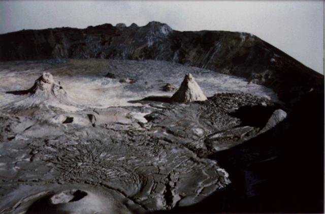 |
Figure 33. Photograph of the summit crater of Ol Doinyo Lengai, 27 December 1993. View is approximately to the N. The tall spatter cones in the upper left (T20) and upper right (T5/T9) rise about 20 m above the surrounding lava flows. June 1993 lava flows are visible at left center with surface fractures; the blocky lava flow F35 is E of T5/T9. Cone T30 is in the left foreground. Courtesy of Franck Pothe. |
The crater was visited on 19-21 January 1994 by Kevin Koepenick, Susan Brantley, and Andrew Nyblade (Penn State), Gary Rowe (USGS), and Constantine Moshi (Tanzania Geological Survey). Field work consisted of fumarole sampling, soil gas sampling, and soil flux measurements in the N rim area. Sporadic rumbling, cracking, and groaning noises emanated from the center of the crater, but were particularly evident at large fractures at the S edge of an oval-shaped depression between cones T5/T9 and T20 (figure 34). Rumbling noises were also heard from near T23, which exhibited vigorous high-temperature gas discharge. Gas emissions were also present from T5/T9, T8, T20, and the fractures at the S edge of the depression.
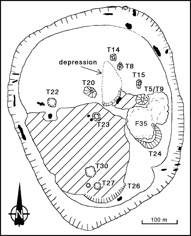 |
Figure 34. Sketch map of the summit crater of Ol Doinyo Lengai, 21 January 1994, showing spatter cones and lava flows (hatched and F35). Irregular black areas along the crater rim and on the crater floor are fumaroles. Original sketch by Barry Dawson, Harry Pinkerton, and David Pyle; courtesy of Kevin Koepenick. |
A temperature survey of all accessible fumaroles was conducted on 19 January. Fractures in the crater walls were lined with native sulfur crystals and weakly emitted gas and steam, with a distinct sulfur smell, at temperatures of 50-80°C. Temperatures of crater-floor fumaroles ranged from 65 to 273°C; most emitted steam without a sulfur smell. The highest temperatures were recorded from cone T8 (248°C) and from a fracture just to the E (273°C). Temperatures of the larger cones were not measured due to the potential hazard.
Geological Summary. The symmetrical Ol Doinyo Lengai is the only volcano known to have erupted carbonatite tephras and lavas in historical time. The prominent stratovolcano, known to the Maasai as "The Mountain of God," rises abruptly above the broad plain south of Lake Natron in the Gregory Rift Valley. The cone-building stage ended about 15,000 years ago and was followed by periodic ejection of natrocarbonatitic and nephelinite tephra during the Holocene. Historical eruptions have consisted of smaller tephra ejections and emission of numerous natrocarbonatitic lava flows on the floor of the summit crater and occasionally down the upper flanks. The depth and morphology of the northern crater have changed dramatically during the course of historical eruptions, ranging from steep crater walls about 200 m deep in the mid-20th century to shallow platforms mostly filling the crater. Long-term lava effusion in the summit crater beginning in 1983 had by the turn of the century mostly filled the northern crater; by late 1998 lava had begun overflowing the crater rim.
Information Contacts: K. Koepenick, Pennsylvania State Univ; F. Pothe, LAVE.