Report on Long Valley (United States) — April 1994

Bulletin of the Global Volcanism Network, vol. 19, no. 4 (April 1994)
Managing Editor: Richard Wunderman.
Long Valley (United States) Summary of 1992-93 seismicity and deformation
Please cite this report as:
Global Volcanism Program, 1994. Report on Long Valley (United States) (Wunderman, R., ed.). Bulletin of the Global Volcanism Network, 19:4. Smithsonian Institution. https://doi.org/10.5479/si.GVP.BGVN199404-323822
Long Valley
United States
37.7°N, 118.87°W; summit elev. 3390 m
All times are local (unless otherwise noted)
The following report summarizes caldera seismicity and deformation during 1992-93.
Earthquake activity within the caldera gradually increased through 1993, with the level of activity significantly higher than in 1992 (figure 16). More than 30 earthquakes of M >3 occurred within the caldera during 1993; six were associated with a swarm on 27 November. By comparison, only four events in 1992 had M >3. The level of activity in the Sierra Nevada block, S of the caldera, was also higher in 1993, with over 30 M >3 earthquakes, compared to 14 in 1992. During 10-15 August 1993, the Red Slate Mountain swarm was the most intense earthquake sequence of the year in the region. It included the largest event (M 4.5) and the largest number of events (~400 M >1) for any one swarm.
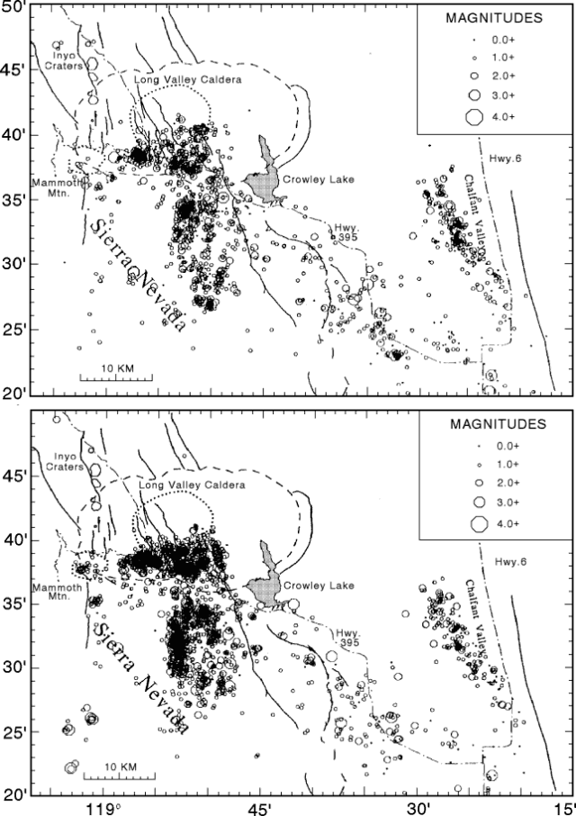 |
Figure 16. Earthquake epicenters in the Long Valley region during 1992 (top) and 1993 (bottom). Courtesy of the USGS. |
An interesting episode of seismic activity in the Long Valley region followed the 28 June 1992 Landers earthquake (M 7.4) in southern California, >400 km S. Local increases in seismicity triggered by the Landers earthquake were also recognized in the Geysers geothermal area and in Yellowstone National Park, over 1,200 km from the epicenter. These were clear examples of seismic "remote-triggering."
A series of >60 long-period earthquakes began beneath the SW flank of Mammoth Mountain during a mid-1989 earthquake swarm, and continued through 1993. These events lacked significant energy at frequencies above 5 Hz, distinguishing them from the much more common volcano-tectonic earthquakes. Reliable hypocenter locations were determined for 30 long-period events in 1992. Focal depths ranged from 10 to 28 km, distinctly deeper than the 2-10 km depth range for local tectonic earthquakes. Most of the long-period events were located between Mammoth Mountain and Red Cones (a pair of Holocene basaltic cinder cones 4 km SW of Mammoth Mountain), although two were located 5-7 km W of Mono Craters and one was within the caldera beneath the W moat. Intervals between events ranged from weeks to months, with individual occurrences typically consisting of several events within a few minutes. Magnitudes were in the 0.7-2.2 range. In 1993, long-period events beneath the SW flank of Mammoth Mountain were detected at depths of 10-25 km. Instruments detected eleven episodes of long-period activity from March through December 1993. Approximately half were solitary events with the rest consisting of bursts of several events over time intervals of 1-2 minutes. All of the long-period events in 1993 were small; the largest had a magnitude of ~1. Similar sporadic long-period events have been recognized beneath Lassen Peak, Medicine Lake caldera, and young volcanic areas in Japan. Evidence suggests that occasional long-period events at mid- to lower-crustal depths are common beneath areas of Holocene volcanism and are not indicative of imminent volcanic activity.
Deformation measurements from late 1989 through 1992, using a two-color geodetic distance-meter (geodimeter), revealed elevated deformation rates across the caldera compared to the modest rate that characterized the last half of the 1980's. Deformation remained steady in 1993 at 2-3 ppm/year. The increased rate of seismicity, however, is still not adequate to account for the deformation that has accumulated since 1990. Geodimeter data and annual GPS surveys of the regional Long Valley-Mono Craters geodetic network indicated that caldera deformation was dominated by inflation of the resurgent dome, driven by a pressure source at a depth of 5-8 km. However, this single source cannot fully account for either the regional deformation pattern or the geodimeter and 1988-92 leveling data. These data sets require a second, relatively deep (>15 km) inflation source somewhere beneath the SW margin of the caldera and Mammoth Mountain, although the location is poorly constrained. Analysis of the combined data sets indicated that the pressure source beneath the dome may have a flattened ellipsoidal shape, and that normal slip on the medial graben faults may have accompanied dome inflation.
Further References. Hill, D.P., Reasenberg, P.A., Michael, A., and 28 others, 1993, Seismicity remotely triggered by the magnitude 7.3 Landers, California, earthquake: Science, v. 260, p. 1617-1623.
Langbein, J., Hill, D.P., Parker, T.N., and Wilkinson, S.K., 1993, An episode of reinflation of the Long Valley caldera, eastern California: 1989-1991: Journal of Geophysical Research, v. 98, p. 15,851-15,870.
Pitt, A.M., and Hill, D.P., 1994, Long period earthquakes in the Long Valley caldera region, eastern California: Geophysical Research Letters (in press).
Geological Summary. The large 17 x 32 km Long Valley caldera east of the central Sierra Nevada Range formed as a result of the voluminous Bishop Tuff eruption about 760,000 years ago. Resurgent doming in the central part of the caldera occurred shortly afterwards, followed by rhyolitic eruptions from the caldera moat and the eruption of rhyodacite from outer ring fracture vents, ending about 50,000 years ago. During early resurgent doming the caldera was filled with a large lake that left strandlines on the caldera walls and the resurgent dome island; the lake eventually drained through the Owens River Gorge. The caldera remains thermally active, with many hot springs and fumaroles, and has had significant deformation, seismicity, and other unrest in recent years. The late-Pleistocene to Holocene Inyo Craters cut the NW topographic rim of the caldera, and along with Mammoth Mountain on the SW topographic rim, are west of the structural caldera and are chemically and tectonically distinct from the Long Valley magmatic system.
Information Contacts: D. Hill, USGS Menlo Park.