Report on Llaima (Chile) — April 1994
Bulletin of the Global Volcanism Network, vol. 19, no. 4 (April 1994)
Managing Editor: Richard Wunderman.
Llaima (Chile) Eruption with 4 km ash column, subglacial lava, lahars, and flooding
Please cite this report as:
Global Volcanism Program, 1994. Report on Llaima (Chile) (Wunderman, R., ed.). Bulletin of the Global Volcanism Network, 19:4. Smithsonian Institution. https://doi.org/10.5479/si.GVP.BGVN199404-357110
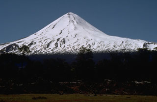
Llaima
Chile
38.692°S, 71.729°W; summit elev. 3125 m
All times are local (unless otherwise noted)
At about 0600 on 17 May this glacier-capped stratovolcano. . . began a Strombolian-to-subplinian eruption with associated lahars and flooding. The eruption produced a column composed of ash, gases, and steam that reached ~ 4,000-5,000 m above the summit, which itself has an elevation of 3,125 m. Tephra fell over a cigar-shaped zone trending about ESE (figures 3 and 4). In early assessments of the eruption, workers estimated the VEI as about 2 or 3 (moderate to moderately large).
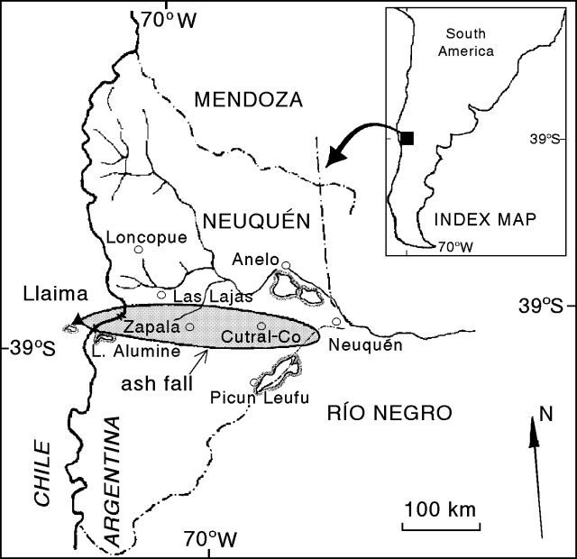 |
Figure 3. Map showing location of the 17 May Llaima ash-fall deposit. The shaded area includes ash of thickness greater than about 1 mm. Dash-dot lines show province boundaries in Argentina: Mendoza, Neuquén, and Río Negro. Base map provided courtesy of Daniel Delpino and Adriana Bermudez (A.C.V.V.R.). |
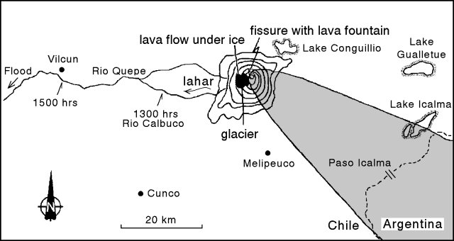 |
Figure 4. Annotated sketch map of the area near Llaima, emphasizing aspects of the 17 May eruption adjacent to the volcano. Contours are only drawn for the volcano, not the surrounding topography. Lowest contour shown is at ~ 1,600 m (200 m contour interval). Labelled times indicate arrival of lahars at various points along the rivers. Courtesy of Hugo Moreno. |
Lava, lahars, and flooding. Llaima has two historically active craters, one at the summit and the other to the SE. This eruption issued from a fissure that grew in the crater at the summit (figure 4). The 500-m-long, SW-trending fissure produced explosions at 3-second intervals and lava fountains. A lava flow developed. The flow drained across the bottom of a glacier located on Llaima's W flank.
Runoff from melting snow and ice caused lahars to descend the W flank into the Calbuco and Quepe rivers. Arrival times for the lahars are shown for two points on figure 4. At further distances from the volcano flooding occurred.
Plume. The ash plume was initially seen for at least 40 km, reaching Lake Icalma, Chile (figure 4) and Lake Aluminé, Argentina (figure 3). Later, at 0930, one witness at Paso Icalma (figure 4) saw a "big, dark, and dense ball of smoke" rising in the sky.
Ash also fell in the towns of Zapala and Cutral-Co, in Neuquén Province, Argentina, settlements with a combined population of ~ 105,000 (figure 3). It fell between the hours of 1330 and 1430 in Zapala, and beginning at 1530 in Cutral-Co. In these towns, falling ash hampered all normal activities and irritated people's eyes and respiratory systems. In the first stage of the ash advance, the sky changed from open sunlight to a dark ash cloud looming over the horizon. About a half hour later the ash cloud completely engulfed the sky.
Ashfall was weak at a meteorological station ~20 km NNE of the town of Neuquén, a location outside and E of the 1 mm isopach shown on figure 3, and a distance of 300 km from Llaima. The time given for this ash fall was 1600, just half an hour after ash began falling at Cutral-Co. Another report, however, mentioned light ashfall at essentially the same spot (the Neuquén airport) beginning at 1900.
Pilots on at least five commercial flights recognized the plume; available reports for 17 May covered these times: (a) between 0900 and 1000, (b) 1330, and (c) between 1600 and 1700. For these intervals, the available pilot reports describe the plume as follows: (a) fumarolic, (b) a volcanic cloud, and (c) tenuous clouds quickly dispersing during what was described as a lull in the eruption. Besides these reports (provided by Raul Rodano), Daniel Delpino and Adriana Bermudez mentioned one other: It stated that the plume rose 10 km above Llaima.
Using the infrared capability of geostationary satellite Meteosat 3, Raul Rodano imaged the plume for the time 1200, 17 May. He also detected the plume between 1800 and 1900, but after this it became indistinguishable from weather clouds.
Description of the non-proximal ash fall. In Neuquén Province, Argentina, the blanket of ashfall over 1 mm thick was distributed over an area of ~ 37,680 km2 (figure 3). In Argentina, the ash within this isopach was mostly 1-2 mm thick but in some areas the accumulations reached 2-5 cm thick. Near-source deposits in Chile may be thicker, but this has yet to be reported.
Table 1 shows grain-size analyses for tephra collected in Zapala and in Paso Icalma (at 1700). In Zapala the tephra was dominantly dark gray to black in color. The ash was examined by A. M. Case and determined to be composed of amber-colored glass shards of presumed mafic composition. Phenocrysts included plagioclase, pyroxene, and iron-titanium oxides.
Table 1. Preliminary grain-size analysis for two localities in Neuquén Province, Argentina. Dashes indicate lack of significant material in stated size range. Exact values for the size ranges require clarification, but diameters in one classification scheme are given in parenthesis. Data provided courtesy of Daniel Delpino and Adriana Bermudez, A.C.V.V.R.
| Grain Sizes | Paso Icalma (45 km) | Zapala (~135 km) |
| Fine lapilli (> 2 mm) | 9% | -- |
| Coarse ash (< 2 mm) | 25% | -- |
| Medium-to-coarse ash | -- | 1% |
| Medium ash | 21% | -- |
| Fine ash (< 0.06 mm) | 32% | 44% |
| Very fine ash | 6% | 45% |
| Dust | 7% | 10% |
Ongoing monitoring, damage estimate, and history. Gustavo Fuentealba set up some portable seismographs that were to be joined by additional instruments from the national civil defense agency (ONEMI). According to an ONEMI report the eruption was preceded by seismic activity.
Both during and after the eruption, volcanologists communicated closely with their respective civil authorities. In Argentina, routine commercial flights were suspended in order to prevent encounters with the ash plume. In Chile, according to Norman Banks, ten staff members of the Conguillio national park and 22 families in the highest risk zones were evacuated, 7 by helicopter. Another 2,000-3,000 inhabitants of the towns of Melipeuco (15 km SSE) and Cherquenco (18 km W) were preparing for possible evacuation.
According to Norman Banks: "The current eruption has been preceded by several years of unrest, [with Llaima] sending a steam column to 1 km in September of 1992, and provoking two other brief episodes of steam or heightened seismic activity, the latest in December of 1993." He also noted that lahars associated with the current eruption caused an estimated $1.25 million (US) damage to Chilean roads and bridges.
Geological Summary. Llaima, one of Chile's largest and most active volcanoes, contains two main historically active craters, one at the summit and the other, Pichillaima, to the SE. The massive, dominantly basaltic-to-andesitic, stratovolcano has a volume of 400 km3. A Holocene edifice built primarily of accumulated lava flows was constructed over an 8-km-wide caldera that formed about 13,200 years ago, following the eruption of the 24 km3 Curacautín Ignimbrite. More than 40 scoria cones dot the volcano's flanks. Following the end of an explosive stage about 7200 years ago, construction of the present edifice began, characterized by Strombolian, Hawaiian, and infrequent subplinian eruptions. Frequent moderate explosive eruptions with occasional lava flows have been recorded since the 17th century.
Information Contacts: H. Moreno, SERNAGEOMIN, Temuco (also at Univ de Chile); ONEMI, Santiago; G. Fuentealba, Univ de la Frontera, Temuco; N. Banks, American Embassy, Santiago; El Mercurio news articles; R. Rodano, Aerolineas Argentinas, Buenos Aires; D. Delpino and A. Bermudez, A.C.V.V.R., Neuquén, Argentina.