Report on Rinjani (Indonesia) — May 1994
Bulletin of the Global Volcanism Network, vol. 19, no. 5 (May 1994)
Managing Editor: Richard Wunderman.
Rinjani (Indonesia) Ashfalls cause aviation warnings; lava flows cover summit area
Please cite this report as:
Global Volcanism Program, 1994. Report on Rinjani (Indonesia) (Wunderman, R., ed.). Bulletin of the Global Volcanism Network, 19:5. Smithsonian Institution. https://doi.org/10.5479/si.GVP.BGVN199405-264030
Rinjani
Indonesia
8.42°S, 116.47°E; summit elev. 3726 m
All times are local (unless otherwise noted)
In May a glow was noticed on the crater floor of Barujari cone, which has undergone no significant activity since August 1966. A portable seismograph (PS-2) and telemetry seismograph (Teledyne) were put into operation on 27 May and 9 June, respectively. One volcanic earthquake event/day was recorded on 27, 28, 30, and 31 May. After 4 June, however, volcanic tremor with a maximum amplitude of 35 mm was recorded, presumably associated with the upward movement of magma.
At 0200 on 3 June, Barujari cone began erupting by sending an ash plume 500 m high. One 8 June press report described emission of "smoldering lava" and "thick smoke," as well as ashfall in nearby villages from an ash cloud rising 1,500 m above the summit. Between 3 and 10 June, up to 172 explosions could be heard each day from the Sembalun Lawang volcano observatory (~15 km NE). During this period, seismic data indicated a dramatic increase in the number of explosions per day, from 68 to 18,720 (figure 2). Eruptions were continuous at least through 19 June, with maximum ash plume heights of 2,000 m on 9-11 June (figure 2).
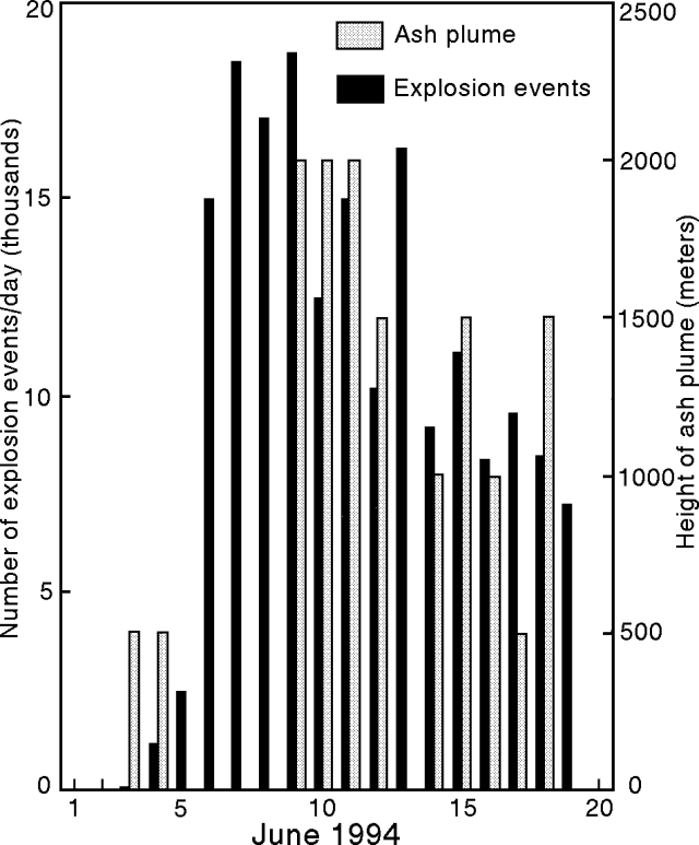 |
Figure 2. Daily number of explosion earthquakes and height of the ash plume at Rinjani, 3-19 June 1994. Courtesy of VSI. |
The ash plume generally drifted SE, depositing up to 30 mm of ash on the island (figure 3). Strombolian eruptions ejected pyroclastic material <2 m in size as high as 600 m above the vent; this material fell in a restricted proximal area around the cone and in the lake. Lava flows began on 8 June and partially covered previous lava flows from Rombongan (in 1944) and Barujari (in 1966) (figure 4).
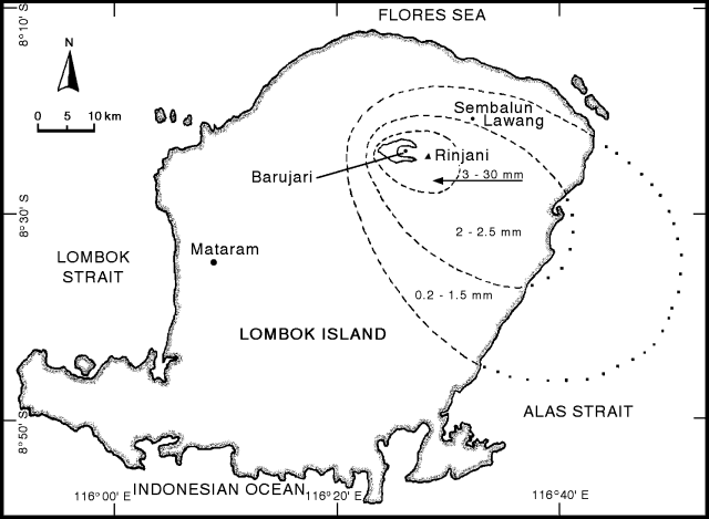 |
Figure 3. Distribution of ash from Rinjani eruptions, 3-19 June 1994. Courtesy of VSI. |
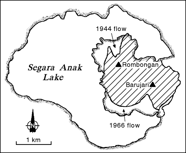 |
Figure 4. Segara Anak caldera lake at Rinjani showing lava flows from the Rombongan dome (1944), Barujari cone (1966), and the recent lava flows of June 1994 (slash pattern). Courtesy of VSI. |
A series of aircraft warnings based on pilot reports and weather satellite images indicated much larger plumes than suggested by the ground observations. First, an eruption at about 1200 on 7 June produced a long plume that caused a large number of aviation warnings. The plume, located on satellite imagery, extended 120 km S of Rinjani and was beginning to disperse by 1530. A pilot report at 1645 on 7 June indicated a "smoke" plume to 13.5 km altitude moving ESE, but by 2345 the plume was indistinguishable on satellite imagery. The imagery showed a plume around 0633 on 8 June, which extended at least 83 km SE of the volcano. Aircraft were advised to avoid this area to an altitude of 10.5 km (35,000 feet).
Second, at 1645 on 9 June a cloud with volcanic ash was evident on satellite imagery within 56 km of the volcano rising up to an altitude of 4.5 km (15,000 feet). The plume was apparently not elongated on the image but the report stated: "Expect cloud to drift W."
In apparent conflict with ground observations and satellite imagery observed by Australian meteorologists, a GOES satellite image at 1831 on 9 June obtained by Steve Matthews revealed a N-directed plume. This straight, distinct plume originating from Lombok Island trailed N for 800 km over SE Borneo, where it merged with a dense cloud bank. The plume widened from ~50 km across at a point 100 km N of the island to 100 km across where it met the Borneo coast.
Satellite imagery at 0830 on 10 June indicated a cloud with ash from 74 km SE to 56 km NW of the volcano to an altitude of 9 km (30,000 feet) with upper level drift to the S. Between 1700 and 2330, an ash cloud (bounded by the following corner points: 8°S, 116°E; 8°S, 117°E; 10°S, 117°E; and 12°S, 118.5°E) reached a height of almost 10 km (34,000 feet). The tongue of ash cloud previously detected drifting S was no longer evident on satellite imagery by 0600 on 11 June, but at 1940 the ash cloud was detected within an area slightly smaller than the previous day. The plume, as seen on satellite imagery at 0800 on 13 June through about 0500 on 16 June, remained over the vicinity of the island, but it exhibited some streaming to the N. At that time the plume began streaming E before drifting N. Pilot reports indicated a plume to 7.5 km (25,000 feet), with patches to 10.5 km (35,000 feet) and spreading N and NE. On 17 June, islands could be seen through the thin plume on satellite imagery. Enhanced AVHRR imagery indicated the probable presence of ash within the plume through 1300 on 18 June. Pilot reports at ~1200 on 18 June again confirmed an ash "smoke" cloud SW of the volcano for a distance of 80 km and an altitude of 10 km (34,000 feet). The plume was consistently observed on the imagery during the night of 18-19 June, but remained thin.
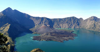
Geological Summary. Rinjani volcano on the island of Lombok rises to 3726 m, second in height among Indonesian volcanoes only to Sumatra's Kerinci volcano. Rinjani has a steep-sided conical profile when viewed from the east, but the west side of the compound volcano is truncated by the 6 x 8.5 km, oval-shaped Segara Anak (Samalas) caldera. The caldera formed during one of the largest Holocene eruptions globally in 1257 CE, which truncated Samalas stratovolcano. The western half of the caldera contains a 230-m-deep lake whose crescentic form results from growth of the post-caldera cone Barujari at the east end of the caldera. Historical eruptions dating back to 1847 have been restricted to Barujari cone and consist of moderate explosive activity and occasional lava flows that have entered Segara Anak lake.
Information Contacts: W. Tjetjep, VSI; BOM Darwin, Australia; S. Matthews, Univ of Bristol, UK; UPI; ANS.