Report on Llaima (Chile) — May 1994
Bulletin of the Global Volcanism Network, vol. 19, no. 5 (May 1994)
Managing Editor: Richard Wunderman.
Llaima (Chile) Additional details on the 17-19 May eruptions
Please cite this report as:
Global Volcanism Program, 1994. Report on Llaima (Chile) (Wunderman, R., ed.). Bulletin of the Global Volcanism Network, 19:5. Smithsonian Institution. https://doi.org/10.5479/si.GVP.BGVN199405-357110
Llaima
Chile
38.692°S, 71.729°W; summit elev. 3125 m
All times are local (unless otherwise noted)
. . .The eruption produced Strombolian-fed, partially subglacial lava flows. The resulting meltwater caused lahars and chocolate-colored floods (figure 5). On 17 May Llaima also produced a column composed of ash, gas, and steam that reached ~ 4,000-5,000 m above its summit. Tephra fell over a 300-km-long, cigar-shaped zone trending about ESE (figure 6); it fell mainly on 17 May but limited falls also took place on 18 and 19 May.
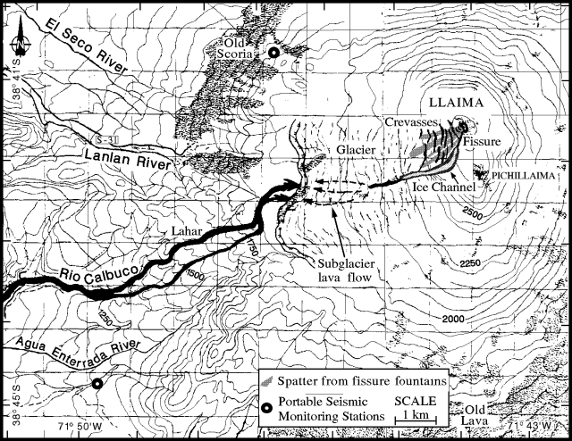 |
Figure 5. Annotated sketch map of the area near Llaima on 21 May 1994. Contour intervals are 50 m (but note that in some snow-and ice-covered areas intermediate contours are missing due to data-transmission problems). The map emphasizes lava and subsequent lahars produced when lava melted glacial ice. The extent and path of the subglacial lava flow are incompletely known. Courtesy of H. Moreno. |
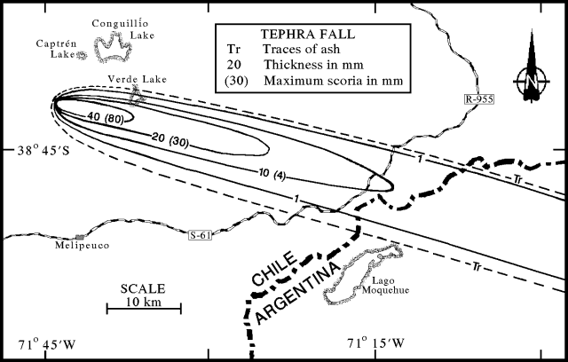 |
Figure 6. Isopach and isopleth map of the Llaima tephra falls of 17-19 May 1994. Values given are in units of millimeters with thicknesses shown first, and grain-size diameters in parentheses. Courtesy of H. Moreno. |
Observations prior to eruption. Hugo Moreno compiled the following list of pre-eruptive observations. In July 1993 after a long rainstorm, Conguillío lake, located on the NE foot of Llaima (figure 6), rose ~ 10 m above its typical seasonal height. It stayed at this elevated height until at least late-December. The magnitude and duration of the lake level rise were unprecedented since 1957, the year of the last big eruption that brought lava to the surface.
In November 1993, rangers of Conguillío national park reported underground rumbling on the N foot of the volcano (Captrén). A video taken from a small aircraft on 25 December showed that the crater area lacked many visible fumaroles. Specifically, the main crater, which was covered by ice, only hosted a very weak fumarole on its SW side. Llaima typically exhibits more vigorous fumaroles; their absence was an anomaly.
A seismic survey (14-17 February, ~10 km E of Llaima at Verde lake: figure 6) found seismic events had an average frequency of about 1.0 Hz, a typical result for Llaima (e.g., 1.2-1.4 Hz in September 1992, 17:8). During 16-17 February a 2-fold increase in the number of events took place, from 90 to 180 events. The events were interpreted as due to magma degassing. A later seismic survey from the same area, 8-10 March, recorded 150-160 events/day with average frequencies in the range 1.0-2.4 Hz. On 22 March a portable seismic station on the W slope of the volcano (Los Paraguas) recorded events reaching still higher average frequency (1.6-3.0 Hz). The consistent increase of the average frequency since February was interpreted as due to slow ascent of magma along the volcano's main conduit.
H. Moreno and S. Barrientos conducted precise leveling, dry tilt, and electronic distance meter (EDM) measurements during 24 February-1 March on the volcano's E flank. Again, except for weak fumes on the SW rim, no fumaroles were seen coming from the main crater. The S summit area ("Pichillaima," figure 5) displayed many small fumaroles; these have progressively increased since 1984.
17-19 May eruptions. The first report of an eruption came from the Melipeuco Police Station, located ~20 km S of the volcano (figure 6), where at 0500-0600 on 17 May observers saw explosions above the main crater. At about 0600 they watched a dense column of ash, gas, and steam issue from the crater; a strong wind dispersed these products toward the ESE.
Between 0900 and 1000 three Chilean domestic (LAN) flights reported the ash column rising 4-5 km above the summit. Ultimately, the plume disrupted several other commercial flights, especially in Argentina.
Between 1100 and 1530 a Chilean Air Force helicopter carried observers to the erupting snow- and ice-capped stratovolcano's W and N sides. On the SSW side of the main crater the aerial observers saw at least four lava fountains escaping from a fissure. The areas covered by spatter from these fountains are shown on figure 5. The fissure was ~500-m long, trending N10°E; it vented small explosions at intervals of ~3 seconds. Lava fountains reached up to ~ 200 m high and joined a lava flow that ran under the adjacent glacier to the W. Llaima's western glacier is significant. Prior to the eruption it had an area of ~ 17.2 km2 and a liquid-phase volume of ~ 367 x 106 m3. Along the fissure the ice underwent rapid, violent melting and vaporization. Many explosions penetrated through the ice.
Aerial observers noted that downslope of the eruption fissure the W glacier discharged steam and explosions. These exhalations indicated that the lava continued some distance beneath the glacial ice, apparently turning toward the W and entering the alpine reaches of either the Lanlan or Calbuco rivers, or both (figure 5). The lava's subglacial path became more apparent later, on 21 May, when the volcano next became visible from the ground. The main crater rim then contained a small notch on its SSW side. The notch held an "ice channel" with a pronounced westerly bend (figure 5). On 21 May, the channel's width varied from about 50 m above the bend to 150 m below it.
On 17 May the invading lava melted sufficient glacial ice so that at about 1200 a lahar was identified moving down the Calbuco river (figure 5). Downstream at a village off the W edge of figure 5 (El Danubio, ~16 km WSW of the summit), the lahar passed at about 1245-0100 carrying trees, sediments, ice blocks, and boulders up to 9 m in diameter. Within a deep gully the lahar reached 35-m wide, 19-m high, and its volume was estimated as 2.5 x 10⁶ m3.
After the lahar reached the Quipe river (~25 km W of Llaima's summit) it advanced as a chocolate-colored flood. At about this point observers in the helicopter flew to the town of Vilcún (43 km W of Llaima's summit), landed on a small bridge, and alerted residents of the advancing floodwaters. The floodwaters arrived at 1515; subsequently the river rose 4.3 m and widened from 32 to 61 m. Estimated water velocity was 13-14 km/hr. During the interval 1630-1700, observers at El Danubio noted the passage of a second flood. In addition to stranding and killing thousands of fish, the lahar and associated flooding nearly covered a cemetery, cut across roads, and destroyed five bridges across the Rio Calbuco; 59 people were rescued from its path.
Observers near the volcano on 17 May saw the ash column blow toward the ESE in the region below about 5 km elevation. During the interval from 0800-1230 ash affected the area immediately adjacent Llaima's E and SE flanks (the Trufultruful river-Verde lake area). During 1000-1330, peaking at 1300-1330, ash fall increased in the area along the ash-distribution axis near the E border of Chile (the Icalma-Cruzaco area). The ash column contained both ash- and water-rich zones.
At 2000 on 18 May, a new, coarser ash fell for several minutes on Cruzaco (~46 km SSE of Llaima). Cruzaco again received ash for the last time on 19 May at 1200; this time it was very fine. Ash samples collected in Cruzaco contained 0.1-4 mm diameter grains of black and reddish-colored scoria with phenocrysts of plagioclase, olivine, and magnetite. Some samples were also taken of water and Coirón grasses that feed livestock, in order to make sulfide, chloride, and other chemical analyses.
Seismic and satellite data. Abnormally high seismicity occurred after the eruption until at least 14 June when monitoring ceased. During this interval, increased seismicity took place on 31 May-1 June, coincident with loud subterranean noises reported from 20 km S at Melipeuco, and summit incandescence seen from 24 km W at Cherquenco.
During the nights of 13-19 June, subterranean rumblings were heard by Pablo Parra of the Hosteria Hue-Telen (Melipeuco) when he was at Verde Lake (figure 6). The rumblings lacked associated smoke-puffs or incandescence. He also reported that although clouds and rain generally shrouded the summit in mid-June, on either 14 or 15 June clear weather revealed a gray-white plume ("normal" for the volcano) changing to a dark-gray plume (distinctly different from "normal"). Parra also noted that Pichillaima exhibited a recent slump on its SE side. He thought the slump was reminiscent of the one seen prior to the explosive 1957 eruption, and he recalled how he and area residents heard similar rumblings for several years prior to that eruption.
Satellite data of Llaima includes GOES-E images collected between 17 and 23 May, excepting 19 May. Steve Matthews, Kath Walley, and Robin Sharphouse have stored the GOES-E images in PDF and TIFF computer format.
The first GOES-E image, at 0230, shortly before the eruption, shows no eruption plume. Plume-like reflectors were observed on the E side of the Chile-Argentina border as follows: (a) on 18 May at 0926, (b) on 20 May at 0926 and 1430, and (c) on 22 May at 1430. On other days cloud cover obscured the area.
The GOES-E image for 18 May contains a small, compact reflector ~100 km E of the volcano. The two 20 May images depict an elongate, plume-like reflector extending from the border directly east of the volcano for ~ 150 km in a SE direction. On the 22 May image a similar feature extends from the border for ~150 km in a NE direction. In all cases these features were more intense than nearby clouds and may represent the ash plume.
Other remarks. The 17 May eruption was ranked by Hugo Moreno as VEI 2 with a strong phreatic component. The exact extent of the subglacial lava flow remains uncertain. The eruption caused no reported casualties.
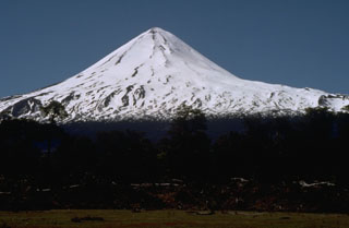
Geological Summary. Llaima, one of Chile's largest and most active volcanoes, contains two main historically active craters, one at the summit and the other, Pichillaima, to the SE. The massive, dominantly basaltic-to-andesitic, stratovolcano has a volume of 400 km3. A Holocene edifice built primarily of accumulated lava flows was constructed over an 8-km-wide caldera that formed about 13,200 years ago, following the eruption of the 24 km3 Curacautín Ignimbrite. More than 40 scoria cones dot the volcano's flanks. Following the end of an explosive stage about 7200 years ago, construction of the present edifice began, characterized by Strombolian, Hawaiian, and infrequent subplinian eruptions. Frequent moderate explosive eruptions with occasional lava flows have been recorded since the 17th century.
Information Contacts: H. Moreno1, G. Fuentealba2, M. Murillo2, M. Petit-Breuilh2, J. Cayupi2, and P. Peña2, SERNAGEOMIN, Temuco, Chile; A. Rivera, Univ de Chile, Santiago; D. Lescinsky, Arizona State University; S. Mathews, Univ of Bristol, U.K.; K. Walley and R. Sharphouse, Ulverston Victoria High School, U.K.