Report on Poas (Costa Rica) — July 1994
Bulletin of the Global Volcanism Network, vol. 19, no. 7 (July 1994)
Managing Editor: Richard Wunderman.
Poas (Costa Rica) Ashfall SW of the summit covers 56 km2
Please cite this report as:
Global Volcanism Program, 1994. Report on Poas (Costa Rica) (Wunderman, R., ed.). Bulletin of the Global Volcanism Network, 19:7. Smithsonian Institution. https://doi.org/10.5479/si.GVP.BGVN199407-345040
Poas
Costa Rica
10.2°N, 84.233°W; summit elev. 2697 m
All times are local (unless otherwise noted)
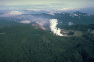
Despite roughly 3 months of rainy weather, the colorful northernmost crater lake that evaporated this past year remained nearly dry, venting became alarmingly noisy, and in the interval from 9 July to 5 August the volcano produced a series of ash falls. These falls were carried to the SW and covered a roughly 56 km2 area.
Increased vigor of fumaroles has led to vapor columns reaching >1 km above the lake floor; the columns were blown to the W and SW. Some of the columns were red to orange in color, presumably due to combustion of sulfur. In the recent past the most vigorous fumaroles were located near the former lake's center. These fumaroles diminished in size; during July the ones located SW of the former lake were of greatest importance.
On 21 July, a fumarole S of the former lake generated a white-colored column; thermocouple measurements of the fumarole revealed a 495°C temperature. The highest pressure fumarole, also located S of the former lake, emitted a red- to orange-colored plume. Continuously jetted gases contained entrained sediment. These escaping gases had a temperature of 515°C, measured with a pyrometer aimed toward the vent. Other fumaroles issued sporadic sediment and colored gases; temperature at the dome was 81°C. ICE and ECG reported jetting gases thrusting to 350 m above the crater floor and then rising convectively to 1 km. Using infrared thermometry, temperatures as high as 700°C were measured in the S-vent area.
Ash was erupted on the night of 9 July and into the morning of 10 July. Continued reports of ash fall came from San Miguel Arriba, Trojas, San Luis de Grecia, Cajon, and Porvenir de Sarchi (figure 53). These reports continued for 2 days; later, mapping and compilation led to an ash distribution map for this and later eruptions in July (figure 53). Blocks were principally limited to the crater area, fine ash covered much of the summit area, and the finest ash blew as far as about 15 km. The fumaroles ejecting lake sediment continued to grow, and ejected ash with blocks. Such events were noted seven times in late July (24, 25, 27, 28, 29, and twice on 30 July). In general, the strongest ash eruptions were accompanied by loud jet-like noises.
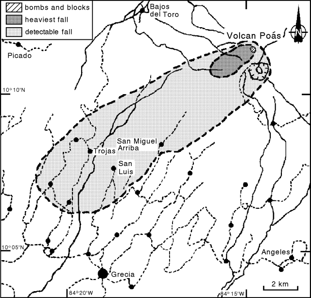 |
Figure 53. Distribution of ash from Poás during July 1994. Scale is approximate; roads indicated by dashed lines, rivers by solid lines, and settlements by dots. Courtesy of OVSICORI-UNA. |
OVSICORI-UNA reported July seismicity from station POA2 (2.5 km SW of the active crater) in terms of several types of events (figure 54). In July, a total of 4,994 events took place. Starting on 26 July several high-frequency (volcano-tectonic) earthquakes took place each day.
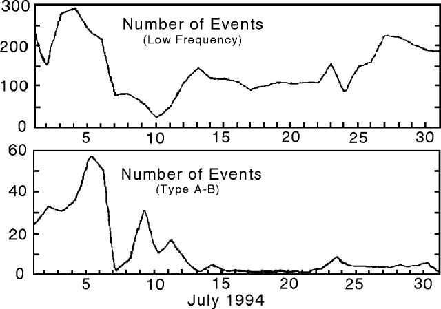 |
Figure 54. Poás seismicity for July 1994. Courtesy of OVSICORI-UNA. |
The amount of deformation on two distance-measurement lines has, since 1973, shown a tendency toward contraction, amounting to about 0.7 and 1.8 ppm/month, respectively. Between 24 June and 5 July both lines suddenly contracted about 19 ppm. From 22 July until the end of the month there were no further significant changes. Back in the interval between 8 March and 12 May a component of two leveling lines deflated slightly (10 µrad). During the last re-occupation of the leveling lines, which took place at the end of July, one line 2 km S of the active crater had inflated by about 17 µrad.
The increased degassing has led to a variety of health and environmental problems. Crops and soils have been damaged. Residents on the W and SW flanks continue to report irritations to the throat, skin, and eyes when gases and ash enter their communities.
On the morning of 22 August an American Airlines flight reported an eruption cloud to ~6 km. Visibility over Poás was poor due to thunder storms to the E and clouds in its vicinity; satellite imagery was unable to detect the plume. Jorge Barquero described this plume as consisting of vapor and gas. A plume on the previous day reached to about 2 km above the vent; heights of these plumes were highly dependant on local wind conditions. As of 22 August, no confirmed ash-bearing plumes had erupted since 5 August.
Geological Summary. The broad vegetated edifice of Poás, one of the most active volcanoes of Costa Rica, contains three craters along a N-S line. The frequently visited multi-hued summit crater lakes of the basaltic-to-dacitic volcano are easily accessible by vehicle from the nearby capital city of San José. A N-S-trending fissure cutting the complex stratovolcano extends to the lower N flank, where it has produced the Congo stratovolcano and several lake-filled maars. The southernmost of the two summit crater lakes, Botos, last erupted about 7,500 years ago. The more prominent geothermally heated northern lake, Laguna Caliente, is one of the world's most acidic natural lakes, with a pH of near zero. It has been the site of frequent phreatic and phreatomagmatic eruptions since an eruption was reported in 1828. Eruptions often include geyser-like ejections of crater-lake water.
Information Contacts: E. Fernández, J. Barquero, V. Barboza, R. Van der Laat, F. de Obaldia, and T. Marino, OVSICORI; G. Soto, G. Alvarado, and F. Arias, ICE; M. Mora, C. Ramirez, and G. Peraldo, UCR.