Report on Pinatubo (Philippines) — August 1994

Bulletin of the Global Volcanism Network, vol. 19, no. 8 (August 1994)
Managing Editor: Richard Wunderman.
Pinatubo (Philippines) Monsoon rains generate lahars and secondary explosions
Please cite this report as:
Global Volcanism Program, 1994. Report on Pinatubo (Philippines) (Wunderman, R., ed.). Bulletin of the Global Volcanism Network, 19:8. Smithsonian Institution. https://doi.org/10.5479/si.GVP.BGVN199408-273083
Pinatubo
Philippines
15.13°N, 120.35°E; summit elev. 1486 m
All times are local (unless otherwise noted)
Lahars from the upper slopes of Pinatubo began again in June 1994, induced by monsoon rains. This volcanic hazard has been frequent in the drainages of Pinatubo during every monsoon season following its June 1991 eruption. Tropical cyclones brought continuous rains on the Pinatubo area in June. Lahars developed in the major drainage channels of the O'Donnell (NE), Sacobia (E), Pasig-Potrero (SE), Marella-Santo Tomas (SW), and Bucao (NW) rivers. On the SE flank, the lahar crisis was more dramatic along the Pasig-Potrero River because it had captured the upper reaches of the Sacobia River in October 1993. The following report, from the Philippine Institute of Volcanology and Seismology, summarizes lahar activity during June-August 1994.
The first lahars were noted on 23 June. Other lahars on 10 July caused damage in downstream villages. They passed under Mancatian Bridge 2 and then curved to the left side of the Pasig-Potrero channel towards Bancal, in barangay Maliwalu (figure 31). These lahars resulted in 2-3 m of deposition on the Mancatian area (from the Angeles-Porac Road to ~2 km upstream) and at least 2 m of in-dike deposition, decreasing to 1-m-thick deposits near Bancal.
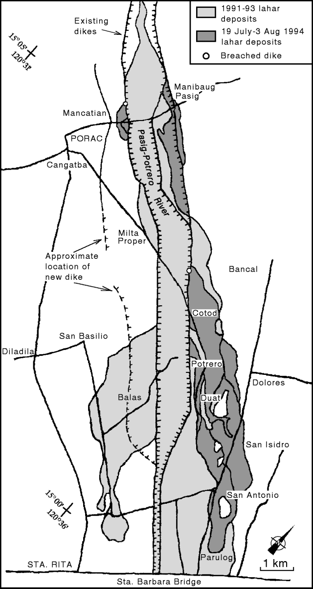 |
Figure 31. Pinatubo lahar deposit map along the Pasig-Potrero River between Mancatian and Santa Rita, 3 August 1994. Courtesy of PHIVOLCS. |
On 19 July, lahars cut through the Mancatian portion of the left dike and encroached on several houses at and near its outer base (figure 31). Aggradation on the left side of the channel forced the active channel to shift towards the right inner dike, so subsequent lahars (25 July) aggraded the right portion of the diked area. Average aggradation along the Mancatian area was ~3 m. Succeeding lahars (26 and 30-31 July) overtopped and breached the inner right dike ~600 m upstream from the road. The breach allowed the lahars to bury areas outside of the inner dike with 2 m of debris. Downstream, strong lahar flows (even as early as 19 July) breached the left dike at Bancal. The breach, ~100 m wide, allowed the lahars to be delivered as far as barangay San Antonio, Bacolor. The bulk of the lahars that passed through the breach were deposited at barangays Potrero and Cotod. Deposits in these areas were as thick as 4 m, especially very near the dike. Deposits in barangay San Antonio and Duat areas were 20-100 cm thick.
Significant deposition in the Mancatian area along the right side of the channel shifted the active flow back towards the left side of the channel so that by 1 August the lahars were again battering the left dike. The active channel maintained this course as of early September.
The passage of Typhoon Ritang on 6-7 August did not bring much rain over the Pinatubo area. However, the lahars generated filled the Pasig-Potrero River from the Delta 5 watchpoint (figure 32) to barangay Mancatian, and caused additional deposition at the alluvial fan area. In-channel aggradation left only a few meters of freeboard along some of the channel and lahars overflowed at the left bank, near the base of Delta 5. The overflowing lahar buried part of an old fan area between Pasig-Potrero River and Sapang Ebus (Taug River) with 0.2-2.0 m of debris. The overflow started on the afternoon of 6 August. The Typhoon Ritang lahars that were conveyed all the way down to the alluvial fan reaches had observed discharges of 60-300 m3/s upon reaching Mancatian. These laminar lahars further aggraded the Cotod and Potrero area by 50-100 cm.
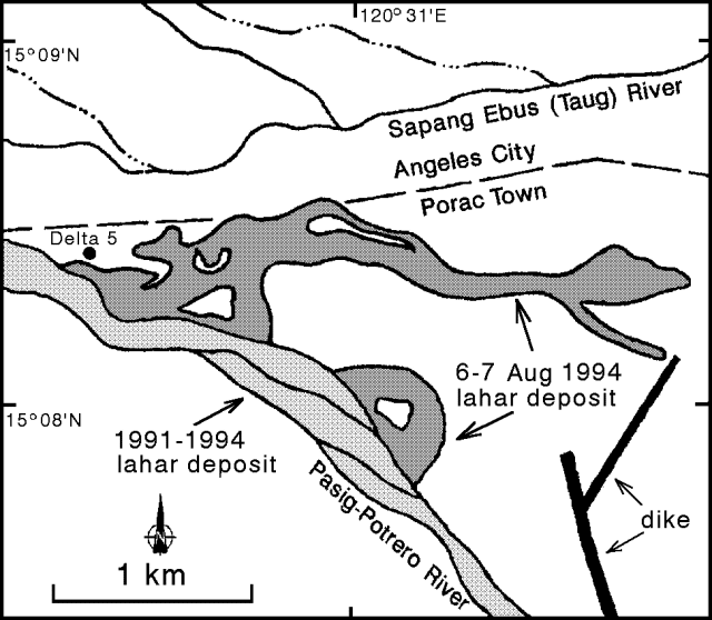 |
Figure 32. Pinatubo lahar deposit map between the Pasig-Potrero River and Sapang Ebus, 17 August 1994. Courtesy of PHIVOLCS. |
After Typhon Ritang and beginning on 8 August, lahars continuously flowed in the Pasig-Potrero River. These non-streaming hyperconcentrated streamflow lahars had an average discharge of 6 m3/s at Delta 5 and 3 m3/s at Mancatian. It is suspected that these lahars were triggered by the breaching of a lake, because no rainfall was recorded by the Upper Sacobia rain gage during 8-16 August. Lahars with the same characteristics were observed in 1991 and 1992 during the release of water from lakes formed on the pyroclastic-flow field by the damming of tributaries with lahar and secondary pyroclastic-flow deposits.
On 16 August, shortly after a large secondary explosion and possibly a secondary pyroclastic flow on the Sacobia pyroclastic-flow field, lahars in the Pasig-Potrero River suddenly ceased and the river became dry. Debris from the secondary pyroclastic flow might have temporarily dammed the river because continuous lahars resumed on 20 August. Aerial surveys on 19 and 30 August revealed several lakes, the biggest of which was in the same location as the 1992 lake. A breach on the outer left dike ~500 m downstream of the Angeles-Porac road allowed these continuous non-rainfall lahars to be delivered and deposited at the alluvial fan area outside of the dike. The accumulation of sediment caused extensive damage outside of the left dike from Barangay Manibaug-Pasig down to Barangay San Antonio in Bacolor, Pampanga.
Geological Summary. Prior to 1991 Pinatubo volcano was a relatively unknown, heavily forested lava dome complex located 100 km NW of Manila with no records of historical eruptions. The 1991 eruption, one of the world's largest of the 20th century, ejected massive amounts of tephra and produced voluminous pyroclastic flows, forming a small, 2.5-km-wide summit caldera whose floor is now covered by a lake. Caldera formation lowered the height of the summit by more than 300 m. Although the eruption caused hundreds of fatalities and major damage with severe social and economic impact, successful monitoring efforts greatly reduced the number of fatalities. Widespread lahars that redistributed products of the 1991 eruption have continued to cause severe disruption. Previous major eruptive periods, interrupted by lengthy quiescent periods, have produced pyroclastic flows and lahars that were even more extensive than in 1991.
Information Contacts: R. Arboleda and M. Matinez, PHIVOLCS.