Report on Llaima (Chile) — August 1994
Bulletin of the Global Volcanism Network, vol. 19, no. 8 (August 1994)
Managing Editor: Richard Wunderman.
Llaima (Chile) New eruptive episode involves multiple explosive events
Please cite this report as:
Global Volcanism Program, 1994. Report on Llaima (Chile) (Wunderman, R., ed.). Bulletin of the Global Volcanism Network, 19:8. Smithsonian Institution. https://doi.org/10.5479/si.GVP.BGVN199408-357110
Llaima
Chile
38.692°S, 71.729°W; summit elev. 3125 m
All times are local (unless otherwise noted)
On 25 August 1994 Llaima volcano began a new eruptive episode. Its last eruption started on 17 May, generating an ash column >4 km high, subglacial lava, lahars, and flooding. The subglacial lava left a melted ice channel down the SW side of the volcano. From a point ~5.4 km W of the summit (Las Paraguas) at 0900 and 0915 on 21 August people felt two earthquakes of intensity II and III. On 25 August, beginning at 0900, observers heard explosions from the principal crater, and at 1135 the first ash column became visible.
Between 1630 and 1800 on 26 August, a gas-and-ash cloud rose 350 m above the summit and a portion of the cloud extended along the ice channel. Continuing from 1930 through the night, the eruption increased in intensity, ejecting gases and incandescent tephra up to 500 m above the summit; some tephra fell as far away as the summit's outer flanks. On 27-28 August the volcano was completely cloud covered, preventing direct visual observations. Some sources reported feeling continuous explosion shocks throughout 27 August, and one source felt 3 clear explosion shocks at 5-second intervals on 28 August. These observations suggested continuing eruptions.
Several seismic stations were installed during the crisis; the first began operation at 1458 on 26 August. During its first 21.2 hours of operation station El Trueno, located 18 km WNW of the principal crater (N of Cherquenco village), revealed harmonic tremor with a predominant frequency of 1.1 Hz. It is fitting to emphasize that in this situation the gain of the seismic system was relatively low (66 on a MEQ-800 instrument), and in May higher gains were in use (78 and 84). In essence, the August tremor had higher amplitude than it did in a roughly 6-hour post-effusive period associated with the May eruption. In addition, other high-frequency signals were detected during parts of 26-27 August, which are still under study. In the last 15 hours of this interval the record contains banded tremor predominantly of 1.0 Hz frequency.
A second seismic station began operation at 1046 on 27 August when a portable MEQ-800 (filter 0-5, gain 72) was installed. Station MELI was placed 14.5 km from the principal crater (N of Melipeuco, a town 20 km SSE of the volcano). The instrument detected harmonic tremor of 1.0-1.2 Hz frequency at roughly 4-5 episodes/minute. The tremor signal was thought to arise from magma-water contact in Llaima's magma-laden conduit system. Tremor of the same frequency continued for the first 6 hours of 28 August (0000-0600), but grew in amplitude and frequency range (to 1.5 Hz). Banded tremor appeared, possibly indicating pressurization processes associated with the ascent of a new batch of magma from depth. In the interval 1100 to 1752 on 28 August the seismicity remained roughly constant, although there was a tendency toward increased energy release.
A third station, installed at 1300 on 27 August, was located 1.1 km from Lago Verde, 7 km E from the principal crater. During 1300-1700 this instrument received such strong tremor signal that it had to be set at minimum gain (60). Later, the station was moved farther away, to Pangueco, 10 km from the principal crater.
On 28 August, scientists monitoring the volcano made several "General Recommendations." These included an Orange alert, 72 hours of vigilant watching of the seismic data, warnings to stay away from Llaima's drainages, and to remain attentive for further official instructions.
A new eruptive phase started at midnight on 28 August when a strong explosion produced a gas-and-ash column. The column was observed in Melipeuco beginning at 0300 when the sky cleared. The activity decreased noticeably by 0510 but reactivated so that between 0640 and 0940 puffs of gas-and-ash in the crater reached 100-600 m above the rim. Thereafter they decayed and grew weak though constant. Between 1120 and 1209 pyroclastic emissions reactivated, discharging a continuous column to 1,000 m above the crater with explosions producing dense scrolls every 5 seconds (VEI = 2).
A 4-hour overflight began at 1125 on 29 August. During that interval the plume mainly rose 400-500 m, but sometimes 1,000 m, above the principal crater's rim. Strong winds came from the W, carrying a visible plume at least 80 km toward the Andean passes "Pino Hachado" and "El Arco" along the Argentine border. The plume lay between 3,200 and 4,000 m altitude; vapor appeared to be absent in both the plume and the column suggesting a very magmatic eruption. The source vent was a 100-m-diameter crater in the E side of the principal crater, surrounded by a small spatter-cone covering the crater floor. From mid-day until 1700 erupted material rose 600-1,000 m and the wind continued to carry the plume E. At 1740 the eruptive intensity decreased but at 1818 it increased, again sending ash 600-700 m above the crater. After 1930 frequent intermittent explosions tossed more ejecta onto the spatter cone verifying its mode of the construction.
Seismicity monitored at station MEI captured the 29 August midnight explosion noted above. In the interval from 2200 on 28 August to 0100 on 29 August, the seismic record showed increased tremor amplitude (3-5 mm at a gain setting of 66) at frequencies of 1.1-1.2 Hz. Later, from 0200-0430, tremor frequency remained stationary at 1.1 Hz, amplitude dropped, and intervals of banded tremor prevailed. Further decreases in amplitude occurred later (0841-1909, 29 August), and while the frequency range of the tremor remained approximately stationary, tremor dropped to a level from where it only appeared episodically.
On 28 or 29 August the Emergency Committee met with members of the community to explain Llaima's activity, including a summary of the eruption character and fundamentals to help maintain civil calm and at the same time to convey potential hazards. Civil calm was called for owing to preparedness by the regional government, community groups, Carabineros, firefighters, the Chilean Air Force, and other groups. Hazard status remained at alert-level Orange.
On 30 August the ash eruption intensified; column height oscillated 2-3.7 km above the crater (corresponding to VEI 2). At 1603 the first dense, vapor-rich ejection took place; 38 minutes later an intermediate phase began, with vapor discharge accompanied by increased amounts of ash. The highest ash column during this phase ascended to 1.5 km above the crater. Vapor-rich and ash-rich phases alternated for ~ 3 hours (until 1901). At 2100 venting stopped. On 31 August, vapor discharge became pronounced around 0900 and continued until 1600.
Beginning at 2000 on 30 August and again at 0155 on 31 August, there was continuous tremor in the 0.9-1.0 Hz frequency range followed by ~ 40 minutes of banded tremor of similar frequency. Seismic quiet prevailed during the next 6 hours at stations MELI and PANG. Seismicity also remained low from 31 August until at least 0941 on 2 September.
Figure 7 shows a sketch of the crater seen during a 1 September overflight of Llaima (in a Chilean Air Force aircraft); the flight took place during calm, clear weather and visibility into the principal crater was excellent. The crater's normally snow-and-ice-covered surface was completely blackened by ashfall; about 15 fumaroles remained, yet ash-emissions were absent. A small cone covered most of the crater floor, its 100-m-diameter, funnel-shaped source vent lay adjacent to the SE crater wall (figure 8). On 1 September, the fissure of melting ice created by the 17 May subglacial lava flow still continued to send up a significant vapor plume. Although mostly westerly winds were noted by observers, the weak ash distribution was over a wide arc, ranging from compass bearings 190-310 (figure 9). There were two lobes of heavier deposition, one toward the N, the other ESE.
Because of decreases in both volcanic and seismic activity, around 2 August scientists lowered the hazard status from Orange to Yellow. However, they expressed concern about potential restriction or blockage of the vent by new deposits in the main crater. They were also concerned about the recent shift in seismic character compared to the previous 4 years.
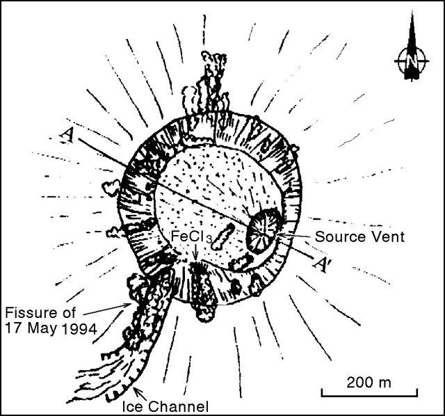 |
Figure 7. Sketch looking down on Llaima's principal crater at 1500 on 1 September. Courtesy of Hugo Moreno. |
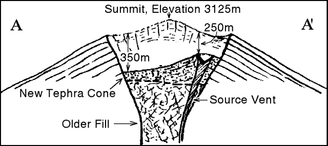 |
Figure 8. Preliminary cross section of Llaima's crater showing estimates of the fill thickness and the funnel-shaped vent from the recent eruption. Courtesy of Hugo Moreno. |
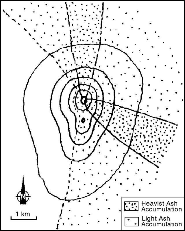 |
Figure 9. Zones of major ash cover from the Llaima eruptions in late-August. The ESE lobe reached about 6 km from the source, the length of the N lobe was unreported. Courtesy of Hugo Moreno. |
Geological Summary. Llaima, one of Chile's largest and most active volcanoes, contains two main historically active craters, one at the summit and the other, Pichillaima, to the SE. The massive, dominantly basaltic-to-andesitic, stratovolcano has a volume of 400 km3. A Holocene edifice built primarily of accumulated lava flows was constructed over an 8-km-wide caldera that formed about 13,200 years ago, following the eruption of the 24 km3 Curacautín Ignimbrite. More than 40 scoria cones dot the volcano's flanks. Following the end of an explosive stage about 7200 years ago, construction of the present edifice began, characterized by Strombolian, Hawaiian, and infrequent subplinian eruptions. Frequent moderate explosive eruptions with occasional lava flows have been recorded since the 17th century.
Information Contacts: H. Moreno1, M. Murillo, M. Petit-Breuilh, and P. Peña, SERNAGEOMIN, Temuco. 1Also at Univ de Chile, Santiago.