Report on Whakaari/White Island (New Zealand) — December 1994

Bulletin of the Global Volcanism Network, vol. 19, no. 12 (December 1994)
Managing Editor: Richard Wunderman.
Whakaari/White Island (New Zealand) Lake persists in Wade Crater; rockslides; inflation continues
Please cite this report as:
Global Volcanism Program, 1994. Report on Whakaari/White Island (New Zealand) (Wunderman, R., ed.). Bulletin of the Global Volcanism Network, 19:12. Smithsonian Institution. https://doi.org/10.5479/si.GVP.BGVN199412-241040
Whakaari/White Island
New Zealand
37.52°S, 177.18°E; summit elev. 294 m
All times are local (unless otherwise noted)
No evidence of eruptive activity was observed on 5 October, although clear conditions allowed for good views into the 1978/90 crater complex (figure 22). The floor of Wade Crater remained occupied by a lake that appeared light-gray with several dark-gray slicks; no convection or geysering was seen. On the rear wall below the May 91 embayment, there was a large audible fumarole. All traces of Royce Crater had been removed by landslide debris, and the floor of Princess Crater contained a small pond. The Wade Crater lake was still light-gray on 11 November with a bright green zone in the NW part. The ridge between TV1 Crater and Wade/Princess continued to fail. During a visit on 21 November the large lake in Wade Crater was covered by plates of gray scum in constant motion. Strong ebullition was occurring in the lake center to a height of 1-2 m. There was no sign of recent eruptions; a number of recent rockfalls had occurred from the steep walls of Wade, Princess, TV1, and Donald Duck craters. A small green lake was present in TV1 Crater.
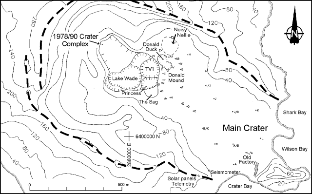 |
Figure 22. Sketch map of Main Crater at White Island showing craters and peg locations as of 21 November 1994. Contour elevations are in meters. Courtesy of the IGNS. |
A complete deformation survey on 21 November showed a continuation of the crater-wide uplift noted during the June and August surveys. The Donald Duck-TV1 area, previously rising much less rapidly than the area to the S, has recently been rising at a comparable rate. This uplift is interpreted by the IGNS as minor crater-wide inflation that began in early 1993, although the strong deflation that characterized the Donald Mound area persisted until mid-1994. Magnetic changes since 28 June 1994 showed a pattern similar to the three previous periods, with a positive anomaly NW of Donald Duck, a negative anomaly N of Donald Mound, and a positive anomaly S of Donald Mound. The magnitude of the changes is slightly less than for the 12 February 1993 to 28 June 1994 period, but the rate of change had increased slightly. These magnetic changes are again interpreted as resulting from a shallow heating under Donald Mound (~50 m deep) and shallow cooling under TV1.
Geological Summary. The uninhabited Whakaari/White Island is the 2 x 2.4 km emergent summit of a 16 x 18 km submarine volcano in the Bay of Plenty about 50 km offshore of North Island. The island consists of two overlapping andesitic-to-dacitic stratovolcanoes. The SE side of the crater is open at sea level, with the recent activity centered about 1 km from the shore close to the rear crater wall. Volckner Rocks, sea stacks that are remnants of a lava dome, lie 5 km NW. Descriptions of volcanism since 1826 have included intermittent moderate phreatic, phreatomagmatic, and Strombolian eruptions; activity there also forms a prominent part of Maori legends. The formation of many new vents during the 19th and 20th centuries caused rapid changes in crater floor topography. Collapse of the crater wall in 1914 produced a debris avalanche that buried buildings and workers at a sulfur-mining project. Explosive activity in December 2019 took place while tourists were present, resulting in many fatalities. The official government name Whakaari/White Island is a combination of the full Maori name of Te Puia o Whakaari ("The Dramatic Volcano") and White Island (referencing the constant steam plume) given by Captain James Cook in 1769.
Information Contacts: B. Scott and P. Otway, IGNS, Wairakei.