Report on Popocatepetl (Mexico) — December 1994

Bulletin of the Global Volcanism Network, vol. 19, no. 12 (December 1994)
Managing Editor: Richard Wunderman.
Popocatepetl (Mexico) Gas and visual observations following the small 21 December eruption
Please cite this report as:
Global Volcanism Program, 1994. Report on Popocatepetl (Mexico) (Wunderman, R., ed.). Bulletin of the Global Volcanism Network, 19:12. Smithsonian Institution. https://doi.org/10.5479/si.GVP.BGVN199412-341090
Popocatepetl
Mexico
19.023°N, 98.622°W; summit elev. 5393 m
All times are local (unless otherwise noted)
Popocatépetl erupted for the first time in decades on 21 December 1994. In the wake of the eruption, Claus Siebe contributed the following report.
"Visual observations at Popocatépetl since 21 January reveal that the emission of ash has decreased in general and become more irregular. Longer time intervals between single series of ash outbursts are observed. Outbursts of ash still occur in single pulses, normally several pulses in a row spaced at intervals of 2-5 minutes. During longer periods of low ash-emissions fumarolic gases are still emitted, preventing direct observation of the crater bottom. Despite this restricted visibility, it is certain that the ash emissions originate in the same area where previously a milky-green lake was located. This lake occupied the depression of the small interior crater that formed during the 1920-27 eruption, when a lava dome was emplaced. During that eruption the lava dome was destroyed by a Vulcanian explosion that created the depression. This interior crater is not located in the center of the main crater but has an eccentric position close to the eastern crater wall.
"In this respect, it is noteworthy that only one of the eight springs monitored by me during the past months has shown a conspicuous anomaly. This spring is located at Axocopan, near Atlixco, 25 km SE of the volcano. Measurements of pH on 11 July, 18 August, and 17 November fluctuated between 5.8 and 6.1. The last measurement taken prior to the 21 December eruption was on 10 December and yielded a pH of 2.5. This anomaly can be regarded as another premonitory sign. The last measurement was taken 14 January 1995 and yielded a value of 5.5, which is almost back to normal. Maybe, during the last weeks prior to the eruption enough pressure built up in the system to allow "magmatic juices" to be expelled laterally and affect the pH of the Axocopan spring."
Following the 21 December eruption a new series of ultraviolet absorption correlation spectrometry (COSPEC) measurements were made by scientists of the Univ of Colima (I. Galindo, A. González, R. Ayala, and L. S. Ivlev). The measurements were requested by the scientific committee organized through the auspices of the Centro Nacional de Prevención de Desastres (CENAPRED). The post-eruption measurements began 48 hours after the eruption, and were also made on 5 other days, with the latest reported being 14 January (figure 8 and table 3).
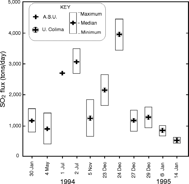 |
Figure 8. Graphical reproduction of Popocatépetl SO2 gas flux shown with an arbitrary horizontal scale. ASU refers to data collected by Stan Williams. Courtesy of Ignacio Galindo. |
Table 3. Popocatépetl SO2 gas flux for 5 November 1994 through 14 January 1995. Courtesy of Ignacio Galindo.
| Day | Average | Maximum | Minimum | Std. Dev. | n |
| 05 Nov 1994 | 1,261 ± 538 | 1,877 | 485 | 285 | 12 |
| 23 Dec 1994 | 2,169 ± 435 | 2,488 | 1,617 | 244 | 8 |
| 24 Dec 1994 | 3,961 ± 577 | 4,555 | 3,402 | 444 | 5 |
| 27 Dec 1994 | 1,167 ± 263 | 1,513 | 987 | 140 | 13 |
| 29 Dec 1994 | 1,237 ± 340 | 1,616 | 935 | 194 | 11 |
| 06 Jan 1995 | 836 ± 169 | 1,054 | 716 | 123 | 12 |
| 14 Jan 1995 | 533 ± 95 | 652 | 462 | 117 | 7 |
The COSPEC instrument was deployed from rented airplanes (flown by R. González and C. De la Cruz) in a variety of weather and atmospheric conditions including air with fine suspended ash (23 December), high overcast clouds (27 December), and clear sky. The plume top was situated at 4,300-5,740 m altitude and traverses beneath the plume were made at altitudes between 3,000 and 4,545 m. The plume was identified and two navigational bench marks were placed using the aircraft's global positioning system (GPS) to assure that the traverses were perpendicular to the plume's axis. The speed and direction for both the plane and the wind were computed at two points inside of the plume. In addition, at the end of some sessions a parallel flight above the plume used the GPS to resample the wind speed.
Figure 8 and table 3 suggest the SO2 flux baseline for 1994 was about 1,000 tons/day, rising to about 4,000 tons/day during the eruption on 24 December. The airborne observations also indicated that the plume did not reach more than ~500 m above the summit, meaning that the thermal output of the volcano was low. The plume mainly consisted of water vapor with a minor ash component. Its color was dark gray to light brown.
Two tiltmeters have now been installed within several kilometers of the summit, and during their first 10 days of operation in mid-January they remained stable ( ± 0.5 µrad). Reflectors for survey lines have been replaced on the mountain's accessible N side; and they have been recently surveyed at 5-7 day intervals. Reportedly, in mid-January the surveyed line-lengths have also remained stable. In addition to four or more seismometers on the mountain, a TV video camera with a telephoto lens was aimed at the summit crater, affording a view of the summit monitored from CENAPRED data center. John Ewert reported that in the first week of January banded tremor prevailed, accompanied by nearly constant ash emission. The seismicity has quieted since then. In mid-January scientists saw several small earthquakes that were followed about 90 seconds later by distinct visible "puffs" seen coming from the summit on the TV video monitor. This, and other behavior, were taken to suggest the magmatic system was open and under comparatively little pressure. A terse summary is available on both activity as late as the end of December, and recommendations for future monitoring (S. McNutt, 1994).
Reference. McNutt, Stephen R., 1994, Report to CENAPRED on activity of Popocatépetl volcano and some recommendations for improved monitoring and response: unpublished manuscript, 7 p.
Geological Summary. Volcán Popocatépetl, whose name is the Aztec word for smoking mountain, rises 70 km SE of Mexico City to form North America's 2nd-highest volcano. The glacier-clad stratovolcano contains a steep-walled, 400 x 600 m wide crater. The generally symmetrical volcano is modified by the sharp-peaked Ventorrillo on the NW, a remnant of an earlier volcano. At least three previous major cones were destroyed by gravitational failure during the Pleistocene, producing massive debris-avalanche deposits covering broad areas to the south. The modern volcano was constructed south of the late-Pleistocene to Holocene El Fraile cone. Three major Plinian eruptions, the most recent of which took place about 800 CE, have occurred since the mid-Holocene, accompanied by pyroclastic flows and voluminous lahars that swept basins below the volcano. Frequent historical eruptions, first recorded in Aztec codices, have occurred since Pre-Columbian time.
Information Contacts: Claus Siebe, Instituto de Geofísica, UNAM, Coyoacán,; I. Galindo, A. González, R. Ayala, and L. S. Ivlev, CUICT-Univ de Colima; John Ewert, Cascades Volcano Observatory, U.S.G.S., USA; Steve McNutt, Alaska Volcano Obs., Univ of Alaska Fairbanks Geophysical Institute, USA.