Report on Nyiragongo (DR Congo) — January 1995

Bulletin of the Global Volcanism Network, vol. 20, no. 1 (January 1995)
Managing Editor: Richard Wunderman.
Nyiragongo (DR Congo) Intermittent lava lake activity continues
Please cite this report as:
Global Volcanism Program, 1995. Report on Nyiragongo (DR Congo) (Wunderman, R., ed.). Bulletin of the Global Volcanism Network, 20:1. Smithsonian Institution. https://doi.org/10.5479/si.GVP.BGVN199501-223030
Nyiragongo
DR Congo
1.52°S, 29.25°E; summit elev. 3470 m
All times are local (unless otherwise noted)
Lava lake activity has continued . . . with intermittent strong red glow above the summit observed at night. Monitoring is done from a small observatory building located in Goma on the N flank of Mt. Goma, an old scoria cone near Lake Kivu . . . (figure 5). With the financial support of the Japanese government, the observatory has recently been supplied with electricity, furniture, a vehicle, and other items to make it more functional. Zairian technical staff and researchers from CRSN-Lwiro maintain the telemetered seismic system and interpret the data.
Intermittent active periods within the lava lake, observed several times each month, are characterized by a sharp increase in tremor intensity followed by a gradual decline. Tremor recorded from 8 November until 18 January (figure 6) revealed a change in mid-December from active periods of 4-6 days to more frequent active periods lasting 1-2 days. This change in the pattern of active periods is believed by Hamaguchi and others (1995) to reflect a change in the hydraulic pressure difference between the magmatic reservoir at depth and the summit reservoir (lava lake). A-type earthquakes recorded during November and December with clear P-phase onset times and moderate amplitudes were clustered along a NNW-SSE strike (figure 7), parallel to the direction of major fissures in the volcanic system. Focal depths for these events were ~15 km, indicating a relationship to the deeper tectono-magmatic activity (Hamaguchi and others, 1995).
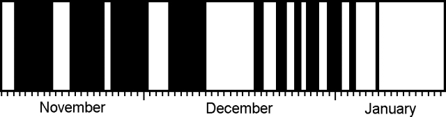 |
Figure 6. Pattern of volcanic tremor at Nyiragongo, 8 November 1994 to 18 January 1995. Solid areas indicate tremor-generating periods when the lava lake was active. Note the change from longer periods of activity in November and early December to shorter but more frequent periods in late December and early January. The tremor pattern for August-October 1994 is similar to November. Modified from Hamaguchi and others (1995). |
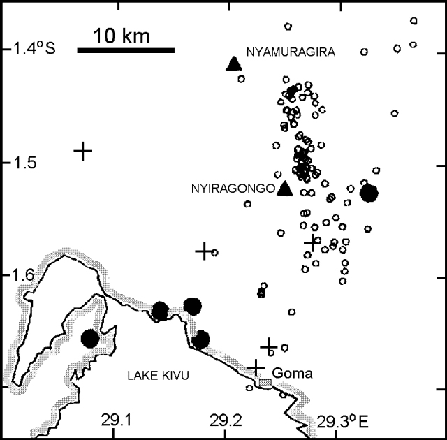 |
Figure 7. Map of the Nyiragongo area showing A-type (tectonic) earthquakes, November-December 1994. Events cluster along a NNW-SSE strike at depths of ~15 km. Crosses mark locations of telemetering seismic stations, and solid circles indicate major refugee camps. Modified from Hamaguchi and others (1995). |
During a UNDHA mission to Zaire on 6-10 February, John Tomblin and consultant Dario Tedesco met with local government officials, made a 24-hour visit to the crater rim of Nyiragongo, and prepared preliminary versions of volcanic hazard maps of both Nyiragongo and Nyamuragira. Future work will include improving the hazard map and preparing detailed descriptions of volcanic eruption scenarios. To better prepare for an event similar to 1977, regular measurements are needed. To establish a baseline for the lava lake, a UN team visited the crater rim on 7-8 February. During this visit precise levelling measurements were made by theodolite of three vertical profiles up the inner crater wall. Careful observations were also made of the 40-m-wide active lava lake, which exhibited frequent minor explosions that ejected spatter bombs within a 60-m radius and sent lava flows across the entire crater floor (800 m in diameter).
Based on eye-witness observations compiled by Hamaguchi and others (1995), the surface of the lava lake rose ~45 m between 23 June and 16 December 1994. Using an average radius of 400 m for the crater, they calculated an average magma-supply rate of 1.3 x 10⁵ m3/day (1.5 m3/s). The estimated maximum rate during the historical period was 2.5 x 10⁵ m3/day ([2.9 m3/s]) during June 1982. This 45 m rise corresponds to ~25 x 106 m3 of new lava. However, it was estimated by the UNDHA team that no more than 10% of his newly emplaced lava remains sufficiently fluid to drain quickly if suitable fractures were to open; the surface of the lava lake is also ~150 m below the level reached prior to the 1977 event.
Reference. Hamaguchi, H., Morita, Y., and Hori, S., 1995, A brief report of volcanic activity at Nyiragongo and Nyamuragira volcanoes in eastern Zaire (November, 1994 - January, 1995): unpublished report on 11 January 1995 of the Observation Center for Prediction of Earthquakes and Volcanic Eruptions, Tohuku University, Japan, 6 p.
Geological Summary. The Nyiragongo stratovolcano contained a lava lake in its deep summit crater that was active for half a century before draining catastrophically through its outer flanks in 1977. The steep slopes contrast to the low profile of its neighboring shield volcano, Nyamuragira. Benches in the steep-walled, 1.2-km-wide summit crater mark levels of former lava lakes, which have been observed since the late-19th century. Two older stratovolcanoes, Baruta and Shaheru, are partially overlapped by Nyiragongo on the north and south. About 100 cones are located primarily along radial fissures south of Shaheru, east of the summit, and along a NE-SW zone extending as far as Lake Kivu. Many cones are buried by voluminous lava flows that extend long distances down the flanks, which is characterized by the eruption of foiditic rocks. The extremely fluid 1977 lava flows caused many fatalities, as did lava flows that inundated portions of the major city of Goma in January 2002.
Information Contacts: J. Tomblin, UNDHA; H. Hamaguchi, Y. Morita, and S. Hori, Tohuku Univ; Director, CRSN, Bukavu.