Report on Unzendake (Japan) — January 1995

Bulletin of the Global Volcanism Network, vol. 20, no. 1 (January 1995)
Managing Editor: Richard Wunderman.
Unzendake (Japan) Eruption rate, seismicity, and number of pyroclastic flows all very low
Please cite this report as:
Global Volcanism Program, 1995. Report on Unzendake (Japan) (Wunderman, R., ed.). Bulletin of the Global Volcanism Network, 20:1. Smithsonian Institution. https://doi.org/10.5479/si.GVP.BGVN199501-282100
Unzendake
Japan
32.761°N, 130.299°E; summit elev. 1483 m
All times are local (unless otherwise noted)
The magma eruption rate during December and January was estimated to be3/day. During the first half of February the eruption rate was almost zero, and the number of volcanic earthquakes and rockfalls declined. The theodolite survey indicated little growth of the endogenous dome during January and the first half of February. Movement has been limited to the central part of the endogenous dome since October 1994, with the E-W oriented spine (dike) moving very slowly through mid-January, and the E part of the dike slowly swelling at a rate of 1-2 m/month (figure 78). This swelling generated multiple small pyroclastic flows toward the NE in late January. The dike surface was reddish brown, and fumaroles were fringed with yellowish sulfur deposits.
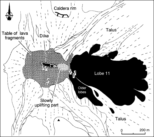 |
Figure 78. Sketch map of the lava dome at Unzen, early February 1995. Solid dome rock is shown as black. The arrow indicates the direction of rockfalls in late January and early February. Solid and dashed lines represent slope dip directions of new and old talus deposits, respectively. Volcanic gas emission points are shown by "f" symbols. Courtesy of Setsuya Nakada, University of Tokyo. |
Microearthquakes beneath the lava dome were generally registered at a rate of <20/day at a station 3.6 km SW, for a total of 322 in January. However, there were 36 events on the 26th and 56 on the 27th. Larger events were felt on 11, 13, 16, and 20 January at the Unzen Weather Station (4 km SW). Only two pyroclastic flows were detected seismically in January; one on the 5th traveled ~5 km SE.
The Coordination Committee for Prediction of Volcanic Eruption met on 6 February to assess the current activity. A statement was issued noting that: 1) lava-dome growth was continuing but the magma supply had decreased since mid-1994; 2) although seismicity has been very low, there have been periodic changes in the number of events since October, which is a new phenomenon; and 3) monitoring and warning systems are still needed during this time of very low activity because volcanism could increase again.
Geological Summary. The massive Unzendake volcanic complex comprises much of the Shimabara Peninsula east of the city of Nagasaki. An E-W graben, 30-40 km long, extends across the peninsula. Three large stratovolcanoes with complex structures, Kinugasa on the north, Fugen-dake at the east-center, and Kusenbu on the south, form topographic highs on the broad peninsula. Fugendake and Mayuyama volcanoes in the east-central portion of the andesitic-to-dacitic volcanic complex have been active during the Holocene. The Mayuyama lava dome complex, located along the eastern coast west of Shimabara City, formed about 4000 years ago and was the source of a devastating 1792 CE debris avalanche and tsunami. Historical eruptive activity has been restricted to the summit and flanks of Fugendake. The latest activity during 1990-95 formed a lava dome at the summit, accompanied by pyroclastic flows that caused fatalities and damaged populated areas near Shimabara City.
Information Contacts: Setsuya Nakada, Volcano Research Center - Earthquake Research Institute, University of Tokyo, Yayoi 1-1-1, Bunkyo-ku, Tokyo 113, Japan; Volcanological Affairs Office, Seismological and Volcanological Dept, Japan Meteorological Agency (JMA), 1-3-4 Ote-machi, Chiyoda-ku, Tokyo 100 Japan.