Report on Barren Island (India) — February 1995

Bulletin of the Global Volcanism Network, vol. 20, no. 2 (February 1995)
Managing Editor: Richard Wunderman.
Barren Island (India) New eruption on 20 December; lava flows reach the ocean
Please cite this report as:
Global Volcanism Program, 1995. Report on Barren Island (India) (Wunderman, R., ed.). Bulletin of the Global Volcanism Network, 20:2. Smithsonian Institution. https://doi.org/10.5479/si.GVP.BGVN199502-260010
Barren Island
India
12.278°N, 93.858°E; summit elev. 354 m
All times are local (unless otherwise noted)
A new eruption . . . was first noticed by the Indian Navy on 20 December 1994. A team composed of scientists from the GSI and Zoological Survey of India arrived at the island early on 24 January, and an aerial survey . . . was made on the 31st. As of 22 February, this mainly Strombolian eruption was still "in its initial stage, gradually gaining momentum."
During January and February, thick clouds of pale brownish gas, dark ash particles, and white steam from the crater area were rising ~200 m at intervals of 30 seconds, accompanied by continuous rumbling and intermittent "cracking" sounds. Two new vents were active, the first within the main crater near the SW corner, and the second ~50 m from the summit down the SW flank. The eruption is believed to have started from the flank vent, around which a new 100-m-diameter subsidiary crater had formed.
Incandescent material (cinder and volcanic bombs) rising to heights of 20 m could be seen from 4 km offshore. Particles ranged in size from a few cubic centimeters to ~1 m3, with the average size being slightly less than 10 cm3. Ejecta filled a valley on the S side of the western-most 1991 lava bed. Lava flows traveled ~1.5 km from the active vents into the sea, producing profuse steaming at the ocean entry. The moving lava front was ~50 m wide and 6 m thick by 22 February. Megascopically the lava was basaltic andesite, similar to that erupted during September 1991, with a high percentage of large plagioclase phenocrysts and frequent olivine in a dark-gray glassy groundmass.
On 9 March at around 0530 GMT astronauts on the Space Shuttle noticed a small plume rising from Barren Island. They made a short video recording (~15 seconds) showing a V-shaped plume that extended for ~3 km before dispersing. Visible imagery from the NOAA-14 (at 0730 GMT) and GMS (0430-0830 GMT) satellites failed to reveal a volcanic plume. A photograph taken from the Shuttle on 14 March at 0749 GMT again showed a small plume blowing W towards the Andaman Islands (figure 2). As this issue went to press, an aviation notice to airmen (NOTAM) on 27 March stated that the intensity of the eruption was unpredictable and advised all aircraft to avoid overflying the area.
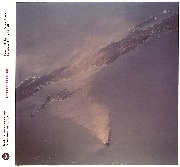 |
Figure 2. Oblique photograph of the Barren Island eruption plume taken from the Space Shuttle, 14 Mar 1995 at 0749 GMT, looking NW. Ash plume is blowing generally W towards the Andaman Islands. NASA photograph STS 067-721A-052. Courtesy of Cindy Evans. |
Geological Summary. Barren Island, a possession of India in the Andaman Sea about 135 km NE of Port Blair in the Andaman Islands, is the only historically active volcano along the N-S volcanic arc extending between Sumatra and Burma (Myanmar). It is the emergent summit of a volcano that rises from a depth of about 2250 m. The small, uninhabited 3-km-wide island contains a roughly 2-km-wide caldera with walls 250-350 m high. The caldera, which is open to the sea on the west, was created during a major explosive eruption in the late Pleistocene that produced pyroclastic-flow and -surge deposits. Historical eruptions have changed the morphology of the pyroclastic cone in the center of the caldera, and lava flows that fill much of the caldera floor have reached the sea along the western coast.
Information Contacts: Director General, GSI; C. Evans, NASA-SSEOP; J. Lynch, SAB.