Report on Villarrica (Chile) — February 1995

Bulletin of the Global Volcanism Network, vol. 20, no. 2 (February 1995)
Managing Editor: Richard Wunderman.
Villarrica (Chile) Sketches of both the crater and ash lobes from late-December eruptions
Please cite this report as:
Global Volcanism Program, 1995. Report on Villarrica (Chile) (Wunderman, R., ed.). Bulletin of the Global Volcanism Network, 20:2. Smithsonian Institution. https://doi.org/10.5479/si.GVP.BGVN199502-357120
Villarrica
Chile
39.42°S, 71.93°W; summit elev. 2847 m
All times are local (unless otherwise noted)
Geologists who made an overflight of the stratovolcano late on the morning of 15 February (in conjunction with Simon Young and John Simmons) observed increasing fumarolic activity. Villarrica gave off moderate puffs of bluish, sulfurous gases at 1-2 minute intervals that rose 300-400 m above the crater before dispersing to the SE.
Between 1040 and 1245 on 15 February the local seismic station (VVN) registered an average of 3 tremor episodes per minute. This tremor had frequencies of 1.3-1.5 Hz, 0.3 Hz below the frequency customarily received (1.8 Hz), and considered a possible indication of a slightly deeper source than typical for both the tremor and the puffs. This behavior continued until 1900 on 15 February. Afterwards tremor diminished and puffing ceased at the fumaroles. These later conditions prevailed until at least 19 February.
The crater, a little more than 200 m in diameter, contained a nested terrace (figure 4). The inner crater floor sat ~200 m below the crater rim, the bottom 50 m of which was black in color, possibly composed of scoria. At the very bottom center an opening exposed ~20 m of material with a bright red glow.
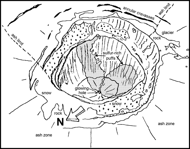 |
Figure 4. Sketch of Villarrica's crater as seen on 15 February 1995. Courtesy of J. Naranjo, G. Fuentealba, and P. Peña. |
Black ash on the glaciers of the E and S flanks extended 4.6 km in the S20 E direction and 2.5 km in the S direction (figure 5). These ash lobes could correspond to eruptions on 25 and 29 December 1994 (19:12).
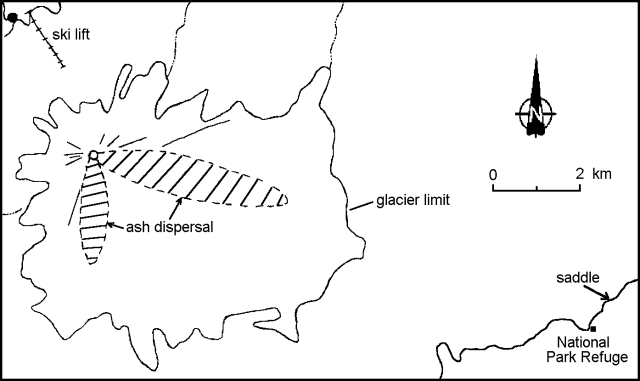 |
Figure 5. Distribution of black ash from Villarrica's crater as seen on 15 February 1995. Courtesy of J. Naranjo, G. Fuentealba, and P. Peña. |
Geological Summary. The glacier-covered Villarrica stratovolcano, in the northern Lakes District of central Chile, is ~15 km south of the city of Pucon. A 2-km-wide caldera that formed about 3,500 years ago is located at the base of the presently active, dominantly basaltic to basaltic andesite cone at the NW margin of a 6-km-wide Pleistocene caldera. More than 30 scoria cones and fissure vents are present on the flanks. Plinian eruptions and pyroclastic flows that have extended up to 20 km from the volcano were produced during the Holocene. Lava flows up to 18 km long have issued from summit and flank vents. Eruptions documented since 1558 CE have consisted largely of mild-to-moderate explosive activity with occasional lava effusion. Glaciers cover 40 km2 of the volcano, and lahars have damaged towns on its flanks.
Information Contacts: J. Naranjo, SERNAGEOMIN, Santiago; G. Fuentealba and P. Peña, SAVO.