Report on Barren Island (India) — April 1995

Bulletin of the Global Volcanism Network, vol. 20, no. 4 (April 1995)
Managing Editor: Richard Wunderman.
Barren Island (India) Ash plumes from three vents; fire fountaining and lava flows
Please cite this report as:
Global Volcanism Program, 1995. Report on Barren Island (India) (Wunderman, R., ed.). Bulletin of the Global Volcanism Network, 20:4. Smithsonian Institution. https://doi.org/10.5479/si.GVP.BGVN199504-260010
Barren Island
India
12.278°N, 93.858°E; summit elev. 354 m
All times are local (unless otherwise noted)
The GSI made an aerial survey on 2 March and a land survey on 8 March 1995 to monitor the ongoing eruption . . . . Surveys in late January revealed mainly Strombolian emissions from two vents near the S crater wall (figure 3; vents A and B). Lava flows had reached the sea by the end of January.
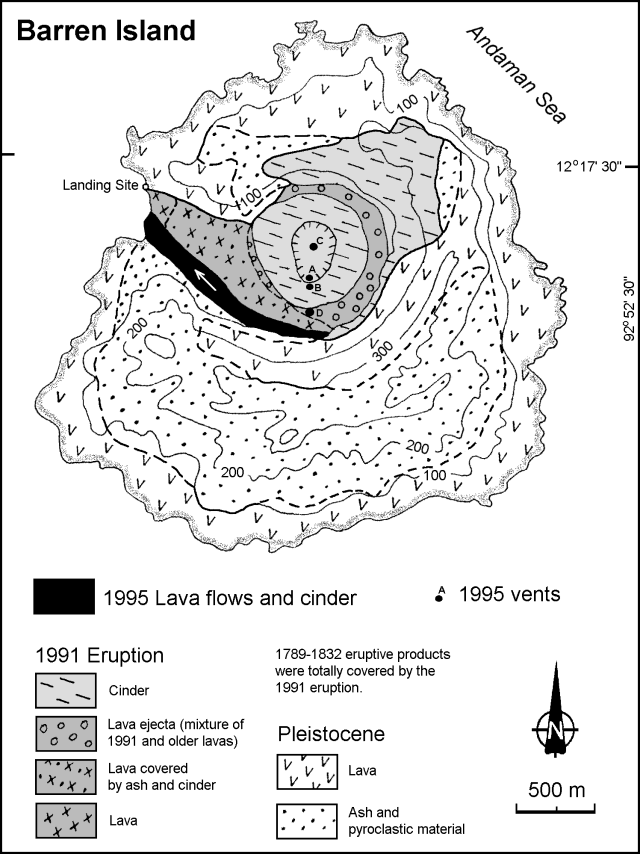 |
Figure 3. Geologic sketch map of Barren Island showing lava flows and distribution of volcanic products from the 1995 and 1991 eruptions. Modified from Haldar and others (1992); courtesy of the GSI. |
The GSI Photogeology and Remote Sensing Division analyzed seven Landsat TM IRS images . . . from November 1994 through February 1995. No signs of eruption were seen on 6 November or 8 December, but conspicuous activity was present on 29 December 1994. Vigorous activity was noted on 9 January. An image from 20 January showed decreasing emissions, but on 25 January the eruption was increasing again. Billowing smoke could be seen through gaps in the cloud cover on 11 February. The lava surface temperature was estimated to be well above 1,000°C on 9 and 25 January, based on preliminary analysis of a few thermally radiant pixels.
On 2 March aerial observers noted thick columns of dark to yellowish gray gas followed by white fumes gushing vigorously from the two vents active in late January. The gas column was rising ~1 km, and the eruption was confined to the S side of the summit crater. Denser air containing volcanic aerosols was encountered ~90 km WSW of the volcano at an altitude of ~2,100 m. Very dense air was noticed ~35 km W, and a very thick gas and smoke cloud was encountered ~15 km W at a height of ~1,500 m.
On 8 March the eruption was largely characterized by phreatomagmatic explosions. In addition to the two previously mentioned vents, the pre-existing conduit in the center of the 1991 crater (figure 3; vent C) was vigorously active. Huge billowing dark emissions from all three summit vents were followed by thick jets of white fumes at intervals of 30-60 seconds, with deep thundering explosions. The combined eruption column rose ~1.5 km before being blown SW by the wind into a horizontal plume. Space Shuttle astronauts observed this plume blowing generally W on 9 and 14 March (20:02).
A fourth vent had also opened at the S foot of the existing volcanic cone by 8 March (figure 3; vent D). It had constructed a small spatter cone from which thick lava was pouring out and a fire fountain was rising ~30 m. Ground temperature ~100-300 m from the foot of the cone was 62-83°C. Hot lava was cascading into the sea along the NW shore, ~200 m S of the landing site, causing the seawater to boil profusely. The lava front thickness had increased from ~6 m on 24 January to ~10 m on 8 March. Ejecta ranged in size up to 10 x 18 x 25 cm. Extensive ashfalls covered the S and W parts of the island, and ash was seen falling as far as 10 km S of the island. Marine life has not been seriously affected; fish were observed ~500 m from shore. Birds were also seen flying over the N part of the island.
Reference. Haldar, D., Laskar, T., Bandyopadhyay, P.C., Sarkar, N.K., and Biswas, J.K., 1992, Volcanic eruption of the Barren Island volcano, Andaman Sea: Journal of the Geological Society of India, v. 39, p. 411-419.
Geological Summary. Barren Island, a possession of India in the Andaman Sea about 135 km NE of Port Blair in the Andaman Islands, is the only historically active volcano along the N-S volcanic arc extending between Sumatra and Burma (Myanmar). It is the emergent summit of a volcano that rises from a depth of about 2250 m. The small, uninhabited 3-km-wide island contains a roughly 2-km-wide caldera with walls 250-350 m high. The caldera, which is open to the sea on the west, was created during a major explosive eruption in the late Pleistocene that produced pyroclastic-flow and -surge deposits. Historical eruptions have changed the morphology of the pyroclastic cone in the center of the caldera, and lava flows that fill much of the caldera floor have reached the sea along the western coast.
Information Contacts: Director General, GSI; Deputy Director General, GSI Eastern Region.