Report on Deception Island (Antarctica) — April 1995
Bulletin of the Global Volcanism Network, vol. 20, no. 4 (April 1995)
Managing Editor: Richard Wunderman.
Deception Island (Antarctica) Report from a 1994-95 austral summer survey
Please cite this report as:
Global Volcanism Program, 1995. Report on Deception Island (Antarctica) (Wunderman, R., ed.). Bulletin of the Global Volcanism Network, 20:4. Smithsonian Institution. https://doi.org/10.5479/si.GVP.BGVN199504-390030
Deception Island
Antarctica
62.9567°S, 60.6367°W; summit elev. 602 m
All times are local (unless otherwise noted)
Deception has been monitored every austral summer since 1986; its flooded caldera forms a 5 x 9 km bay breached to the SW, giving Deception Island a ring shape. This report describes the 1994-95 summer survey, which included geophysical, geochemical, and volcanological work.
Near the Spanish Antarctic station "Gabriel de Castilla" a 500 x 600 m seismic array was deployed. Composed of three, 16-bit digital acquisition systems, the seismic array incorporated the following: 1) a Marck L15B with flat response between 1-48 Hz (12 vertical geophones and 4 horizontal geophones), 2) a Marck L4C with flat response between 0.1-48 Hz (two vertical geophones and four horizontal geophones), and 3) a broad-band, three-component Guralp CMG-3ESP with response between 0.033 and 48 Hz.
Figure 10 shows the acquired seismic data, which were collected from 7 December 1994 through 23 February 1995. The seismic data were subdivided into several groups on the basis of their time-domain and frequency-domain appearance. The resulting groups consisted of 262 volcanic tremors, 145 hybrid events, 300 low-frequency events, and 18 high-frequency (local) events (S - P time under 4 seconds). Applying classical array techniques, the preliminary locations for these events suggested that many came from two areas near 'Vapour Hill' (presumably located on the W side of the island at a spot previously designated 'Steaming Hill' on the map in BGVN 19:09).
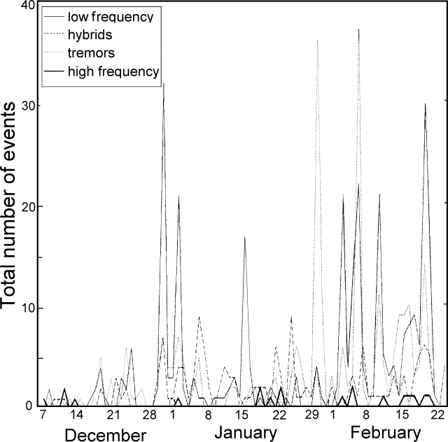 |
Figure 10. Deception Island seismicity, December 1994-February 1995. Courtesy of Alicia Garcia. |
A summary of seismic events detected during previous surveys appears in table 2. Although seismic parameters were not always clearly delineated in previous BGVN reports, the seismic events registered in 1991 and 1992 were thought to have been less energetic than in 1994-95. Although the occurrence of earthquake activity was distributed throughout December, January, and February, the team observed at least 10 days with a notable increase in seismicity, days when volcanic swarms had average durations of ~3-6 hours. Given the absence of volcanic activity the researchers suggested that some of the seismicity may be contributed by thermally driven seasonal change.
Table 2. A summary of detected seismic events at Deception Island during austral summer surveys. "--" = not reported.
| Season | Duration (months) | Total events recorded | Magnitude | SEAN/BGVN (Vol:No) |
| 1987 | 2 | -- | ~0.5 mb | 13:02 |
| 1988 | 2 | -- | ~0.5 mb | 13:02 |
| 1988-89 | 3 | more than 2,000 | -- | 14:03 |
| 1989-90 | 3 | 1,000 | 0.5-2.1 mb | 15:03 |
| 1989-90 | 3 | -- | M 3.2 | 16:05 |
| 1991-92 | 3 | 766 | 0.8-2 (4 of M greater than 3) | 17:04 |
| 1992-93 | 3 (?) | 135 | 0.3-0.9 | 18:03 |
| 1993-94 | 3 | "a few" | 1.5-2 | 19:09 |
| 1994-95 | 3 | 725 | -- | 20:04 |
Although no data were presented, in addition to reoccupying the local gravimetric net, the magnetic field intensity was continuously recorded using three proton precession magnetometers.
Temperatures of fumaroles and hot soils remained stable with respect to those measured in the last survey. The anhydrous component of gases were mainly CO2 (96-99%) and H2S (0.2- 3.9%); SO2 was not detected.
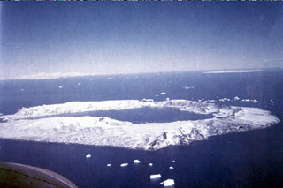
Geological Summary. Ring-shaped Deception Island, at the SW end of the South Shetland Islands, NE of Graham Land Peninsula, was constructed along the axis of the Bransfield Rift spreading center. A narrow passageway named Neptunes Bellows provides an entrance to a natural harbor within the 8.5 x 10 km caldera that was utilized as an Antarctic whaling station. Numerous vents along ring fractures circling the low 14-km-wide island have been reported active for more than 200 years. Maars line the shores of 190-m-deep Port Foster caldera bay. Among the largest of these maars is 1-km-wide Whalers Bay, at the entrance to the harbor. Eruptions during the past 8,700 years have been dated from ash layers in lake sediments on the Antarctic Peninsula and neighboring islands.
Information Contacts: J.M. Ibanez and J. Morales; Instituto Andaluz de Geofísica, Apartado 2145, Univ. Granada, Granada, Spain; A. Garcia and R. Ortiz, Dpto. Volcanologia. Museo Nac. Ciencias Naturales, C.S.I.C., Jose Gutierrez Abascal no. 2, 28006-Madrid, Spain; E. del Pezzo, Dpto. Fisica, Univ. Salerno, Salerno, Italy; C. Risso, Instituto Antartico Argentino, Cerrito 1248, Buenas Aires, Argentina.