Report on Rinjani (Indonesia) — May 1995
Bulletin of the Global Volcanism Network, vol. 20, no. 5 (May 1995)
Managing Editor: Edward Venzke.
Rinjani (Indonesia) Explosive eruption in November 1994; eruptive products from 1994 described
Please cite this report as:
Global Volcanism Program, 1995. Report on Rinjani (Indonesia) (Venzke, E., ed.). Bulletin of the Global Volcanism Network, 20:5. Smithsonian Institution. https://doi.org/10.5479/si.GVP.BGVN199505-264030
Rinjani
Indonesia
8.42°S, 116.47°E; summit elev. 3726 m
All times are local (unless otherwise noted)
The June-October 1994 eruption was visually monitored every day from the VSI observatory 14 km E of the crater, and occasionally from the E rim of the Segara Anak caldera (figure 2). A glassy bomb from this eruption was a basaltic andesite (55% SiO$2); the two previous eruptions (1944 and 1966) were basaltic. Lake temperatures in April 1994 were 31°C close to the active Barujari cone and 20°C on the W side; temperatures on 9 October 1994 were 36 and 31°C, respectively. Declining lake levels were noted on 9 October (~3 m drop, but no comparative date specified) and 20 November (additional tens of centimeters). Only solfatara activity was observed after 9 October, but aviation notices in late October warned of ash clouds above the summit (19:10). A cold lahar killed 30 people on 3 November (19:10).
Eruptive stages and products, June-October 1994. A rapid study of the deposits around the Barujari crater made on 19-20 November 1994 confirmed that the eruption evolved through three distinct stages. The first stage was Strombolian; a red glow was seen in the plume, and scoriae were found under the later deposits. The second stage began 4 or 5 days later, when water contacted magma. It was characterized by short-spaced explosions, with a 3,000-m-high plume heavily laden with fine ash. Around the crater, the older lava flows and the E wall of the caldera were plastered with a white mud-like deposit; a hydro-magmatic, thinly bedded fall deposit, without associated surge deposits. This material was so soaked with water that it produced small mud flows on slopes. A thick andesitic lava flow exposed at the N foot of the cone had no muddy cover. Its effusion was not observed, but it was after the hydro-magmatic stage, and at least before the end of the Vulcanian stage.
The third stage, from August until 9 October, was characterized by stronger explosions more widely spaced in time. These were typically Vulcanian according to photographs of the plume taken by the VSI team. The deposits attributed to this stage were coarse black ash, lapilli, and numerous bread-crust bombs. The bombs were typically several meters long (the longest measured 7 m), partially glassy, and usually broken. A bomb 30 cm long was found 3 km from the crater.
Activity on 21 November 1994. A short explosive eruption took place at 0630 on 21 November 1994 from the Barujari cone (summit elev. 2,376 m). From the NE edge of Segara Anak Lake (figure 7), the convecting plume appeared heavily laden with dark ash, and large bombs were thrown from the eruptive column. The height of the plume was ~2,000 m above the crater. A strong wind blew it W, and no sounds were heard by observers 3 km from the crater. Subsequent explosions were progressively less vigorous, and were sending puffs hundreds of meters high at 1130 when observers could no longer see the volcano. Most of the puffs contained white vapor with minor ash and lapilli. The day before, observers working on Barujari (E. Mulyadi and P.M. Vincent) had noticed no warnings of this impending eruption. These explosions were of the same type as those observed during the last stage of the June-October 1994 eruption at Barujari, indicating that they should be considered late events of that eruption.
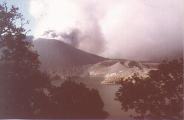 |
Figure 7. Photograph of Barujari cone (left) and Rombongan dome (right) on 21 November 1994, with Segara Anak lake in the foreground. View is looking approximately SW from the NE caldera rim. Courtesy of P.M. Vincent. |
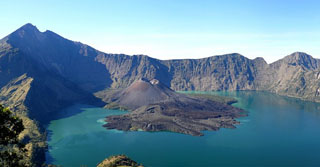
Geological Summary. Rinjani volcano on the island of Lombok rises to 3726 m, second in height among Indonesian volcanoes only to Sumatra's Kerinci volcano. Rinjani has a steep-sided conical profile when viewed from the east, but the west side of the compound volcano is truncated by the 6 x 8.5 km, oval-shaped Segara Anak (Samalas) caldera. The caldera formed during one of the largest Holocene eruptions globally in 1257 CE, which truncated Samalas stratovolcano. The western half of the caldera contains a 230-m-deep lake whose crescentic form results from growth of the post-caldera cone Barujari at the east end of the caldera. Historical eruptions dating back to 1847 have been restricted to Barujari cone and consist of moderate explosive activity and occasional lava flows that have entered Segara Anak lake.
Information Contacts: P. Vincent, Centre de Recherches Volcanologiques-CNRS, France; W. Tjetjep and Eddy Mulyadi, VSI.