Report on Loloru (Papua New Guinea) — August 1995
Bulletin of the Global Volcanism Network, vol. 20, no. 8 (August 1995)
Managing Editor: Richard Wunderman.
Loloru (Papua New Guinea) Weak to moderate steaming, but sublimate deposits in possible decline
Please cite this report as:
Global Volcanism Program, 1995. Report on Loloru (Papua New Guinea) (Wunderman, R., ed.). Bulletin of the Global Volcanism Network, 20:8. Smithsonian Institution. https://doi.org/10.5479/si.GVP.BGVN199508-255030
Loloru
Papua New Guinea
6.52°S, 155.62°E; summit elev. 1887 m
All times are local (unless otherwise noted)
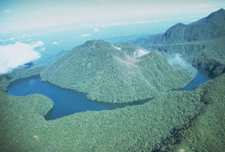
An aerial inspection took place after the 16 August, M 7.8 earthquake 200 km to the NW. Weak-to-moderate, white vapor emissions were observed from the main fumarole field in a valley on the N flank of the summit lava dome. Sublimate deposits in the valley appeared to be less extensive than when last inspected in 1989. The lake at Loloru's summit appeared normal. There was no discoloration of lake water and the level of water appeared to be unchanged.
Geological Summary. Loloru, the SE-most volcano on Bougainville Island, is the source of a broad ignimbrite apron that covers much of the southern part of the island. The summit consists of two nested calderas, and a forested andesitic lava dome that restricts a crescent-shaped lake to the eastern side of the younger caldera. The smooth flanks of the pyroclastic shield are dissected by radiating deep valleys. A pristine lava flow occurs on the SE flank. Loloru is constructed within the 10 x 15 km Pleistocene Laluai caldera. The topographically higher Taroka group of volcanoes to the NW and the Takuan group to the north also were constructed within the caldera and deflected the bulk of Loloru ignimbrites to the south. The most recent of several major Holocene explosive eruptions took place about 3,000 years ago.
Information Contacts: Patrice de Saint-Ours and Ben Talai, RVO.