Report on Yasur (Vanuatu) — August 1995

Bulletin of the Global Volcanism Network, vol. 20, no. 8 (August 1995)
Managing Editor: Richard Wunderman.
Yasur (Vanuatu) Frequent bomb ejections continue; increased activity during 1994
Please cite this report as:
Global Volcanism Program, 1995. Report on Yasur (Vanuatu) (Wunderman, R., ed.). Bulletin of the Global Volcanism Network, 20:8. Smithsonian Institution. https://doi.org/10.5479/si.GVP.BGVN199508-257100
Yasur
Vanuatu
19.532°S, 169.447°E; summit elev. 361 m
All times are local (unless otherwise noted)
During October 1993, a telemetered surveillance station registered variations in the seismicity at Yasur. The station is located 2 km from the crater on the ashflow plain (figure 3). Seismicity (detected at five stations) generally increased from October 1993 to January 1994, corresponding to renewed eruptive activity. Very strong activity from January 1994 to January 1995 (comparable to 1976-77) ejected bombs in a radius of ~400 m from the crater rim (figure 4). Ashfall measured at the surveillance station totaled ~12 cm during January-October 1994. Seismicity remained high throughout 1994, then declined after January 1995.
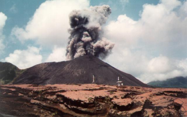 |
Figure 3. Photograph of an explosion at Yasur on 17 March 1994. The ARGOS-linked monitoring station is in the foreground. View is approximately to the W. Photo by M. Lardy, courtesy of ORSTOM. |
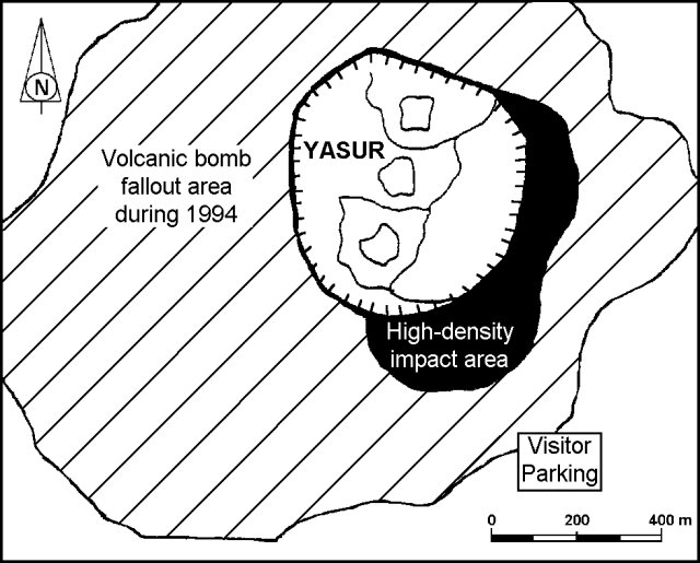 |
Figure 4. Sketch map of Yasur showing the area of volcanic bomb fallout during 1994. Courtesy of ORSTOM. |
Because Yasur is very accessible, it has been promoted as a tourist destination, resulting in a greater number of visitors and greater risk of accidents. In mid-January 1994 and early February 1995, when activity began to decline, there were two accidents with three victims. In one incident, two visitors on the crater rim died when they were struck by a 15 kg bomb ejected from the vent. Although there is little danger when the volcano is having regular explosions at intervals of a few minutes to tens of minutes, the local authorities want to better inform visitors of the constant danger. In January 1994, ORSTOM began publishing a series of booklets to inform the general public of the volcanic risks. Risks discussed include bombs falling near the crater, modifications of the crater topography (raising of the floor, migration of the vent, etc.). In addition, the 200-m distance between the observation site and the active vents, and the very frequent bomb ejections at speeds of 100-300 m/second that have rendered approaching the crater rim dangerous.
Geological Summary. Yasur has exhibited essentially continuous Strombolian and Vulcanian activity at least since Captain Cook observed ash eruptions in 1774. This style of activity may have continued for the past 800 years. Located at the SE tip of Tanna Island in Vanuatu, this pyroclastic cone has a nearly circular, 400-m-wide summit crater. The active cone is largely contained within the small Yenkahe caldera, and is the youngest of a group of Holocene volcanic centers constructed over the down-dropped NE flank of the Pleistocene Tukosmeru volcano. The Yenkahe horst is located within the Siwi ring fracture, a 4-km-wide open feature associated with eruption of the andesitic Siwi pyroclastic sequence. Active tectonism along the Yenkahe horst accompanying eruptions has raised Port Resolution harbor more than 20 m during the past century.
Information Contacts: M. Lardy and D. Charley, Centre ORSTOM, Port Vila, Vanuatu, and Department des Mines et de la Geologie et des Ressources en Eaux; J. Tabbagh, Centre de Teleobservation Informatise des Volcans, Garchy, France; J-P. Eissen, Centre ORSTOM de Brest, France; C. Robin and M. Monzier, Centre ORSTOM, Quito, Ecuador.