Report on Fernandina (Ecuador) — August 1995

Bulletin of the Global Volcanism Network, vol. 20, no. 8 (August 1995)
Managing Editor: Richard Wunderman.
Fernandina (Ecuador) Now-cooling lava and the eruption's impact on plants and animals
Please cite this report as:
Global Volcanism Program, 1995. Report on Fernandina (Ecuador) (Wunderman, R., ed.). Bulletin of the Global Volcanism Network, 20:8. Smithsonian Institution. https://doi.org/10.5479/si.GVP.BGVN199508-353010
Fernandina
Ecuador
0.37°S, 91.55°W; summit elev. 1476 m
All times are local (unless otherwise noted)
Godfrey Merlen was granted permission by the Galapagos National Park Service to make a post-eruption visit to Fernandina. The recent eruption ceased on about 8 April 1995 (BGVN 20:05). Merlen looked at the eruptions impact on plants and animals, and viewed the newly formed lava fields and cone in the absence of the acrid gases and heat present during the eruption.
Merlin arrived at Cape Hammond on 26 July (figure 3) and climbed for 2 hours along a well-known route to the kipuka adjacent the cone. From this point, he approached the cone itself. He noted Jasminocereus cactus, which form a distinctive part of the flora in the area, and, which were partially scalded within several hundred meters of the lava. Surprisingly, they were heavy with fruit.
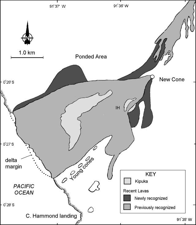 |
Figure 3. Sketch map showing newly recognized lava flows and the location of kipukas, including the one termed "Iguana Hill" (IH). Scale is approximate. |
The cone was approached from the SW. Large blocks of new lava formed the base of the cone, and below them the old lavas were totally covered with a scoria layer. Poking through this layer were a number of Opuntia cactus. Many had been badly burnt by the heat, but they had undergone strong regrowth, and some had up to 9 or 10 new pads. A few flowers were also present.
He ascended the cone (figure 3) easily, due to its firm surface composed of congealed spatter. From the rim he observed that the lava lake had drained, leaving a reddish rubble in the bottom of the crater. A visible entrance to a lava tunnel on the crater's W side probably served as a lava exit route. Circumferential fissures had developed in many areas around the rim, leading to inward collapses. On the N side of the cone's rim, hot spots disclosed by shimmering, heated air indicated that they were still too hot to approach closely.
From the rim one could look upslope and see the earliest flows from the eruption (figure 3). Though previously obscured by gases, it now seems clear that the flow farthest to the N was of significant extent, even though previously unseen. It had traveled a considerable distance past the cone and then turned N, filling in a low area well down toward the coast. Later, lava from the cone butted up against this flow, making a continuous field of new lava.
In descending from the cone's N side towards the "Iguana Hill" kipuka (figure 3), he crossed over the fresh new aa lava, but there were also some smooth patches and many small lava tubes on the surface. The track of the main lava tube could be followed by noting the white encrustations on the rocks. On approach to these encrustations extreme heat was felt. He assumed that a short distance below the surface there were partially liquid lavas that were still degassing. Away from these encrustations the surface of the lava was quite cool.
Although Iguana Hill was wreathed in acidic volcanic gases for many weeks during the eruption, Land Iguanas trapped there survived and four adults were seen. This hardly represents all the iguanas, as the dense scrub vegetation impeded investigation. Many of the plants on the Iguana Hill kipuka were putting out leaves. Zanthoxylum, Croton, and Cordia were all in full leaf, the former were a particularly noticeable bright green.
Blue "smoke" was still visible a little to the NE of Iguana Hill. There was also a little smoke in the low area behind the shoreline. The coast itself was volcanically quiet. Heavy southerly swells broke along a long, black beach that stood in front of the near-vertical sea cliff. This eruption changed conditions at the Cape Hammond landing little, if at all. Flightless cormorants were building nests and some had eggs. The pupping season for the fur seals and sea lion had begun.
A perspective sketch (figure 4) from a point several kilometers offshore shows that the lava flow that started high on the shoulder of the volcano lined up with the westernmost string of cones, including one cone on the coast. However, the new cone, the vent for much of this recently erupted lava, lies off this line to the S.
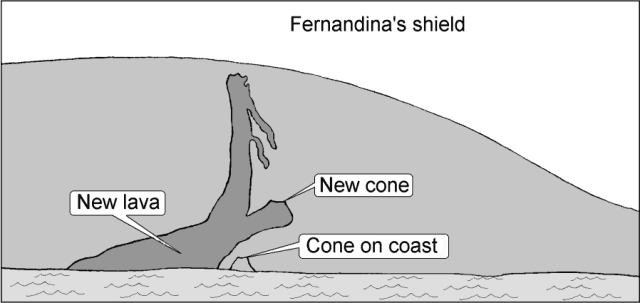 |
Figure 4. Sketch of Fernandina drawn from a point several kilometers offshore looking NE. The sketch shows the alignment of cones and some of the upper lava flows. |
Geological Summary. Fernandina, the most active of Galápagos volcanoes and the one closest to the Galápagos mantle plume, is a basaltic shield volcano with a deep 5 x 6.5 km summit caldera. The volcano displays the classic "overturned soup bowl" profile of Galápagos shield volcanoes. Its caldera is elongated in a NW-SE direction and formed during several episodes of collapse. Circumferential fissures surround the caldera and were instrumental in growth of the volcano. Reporting has been poor in this uninhabited western end of the archipelago, and even a 1981 eruption was not witnessed at the time. In 1968 the caldera floor dropped 350 m following a major explosive eruption. Subsequent eruptions, mostly from vents located on or near the caldera boundary faults, have produced lava flows inside the caldera as well as those in 1995 that reached the coast from a SW-flank vent. Collapse of a nearly 1 km3 section of the east caldera wall during an eruption in 1988 produced a debris-avalanche deposit that covered much of the caldera floor and absorbed the caldera lake.
Information Contacts: Godfrey Merlen, skipper of motor vessel "Ratty," Fundacion Charles Darwin Para Las Islas Galapagos, Estacion Cientifica Charles Darwin, Ecuador.