Report on Rincon de la Vieja (Costa Rica) — December 1995
Bulletin of the Global Volcanism Network, vol. 20, no. 11 (December 1995)
Managing Editor: Richard Wunderman.
Rincon de la Vieja (Costa Rica) Additional details about the 6-10 November eruption
Please cite this report as:
Global Volcanism Program, 1995. Report on Rincon de la Vieja (Costa Rica) (Wunderman, R., ed.). Bulletin of the Global Volcanism Network, 20:11. Smithsonian Institution. https://doi.org/10.5479/si.GVP.BGVN199512-345020
Rincon de la Vieja
Costa Rica
10.83°N, 85.324°W; summit elev. 1916 m
All times are local (unless otherwise noted)
An eruption on 6 November 1995 followed increases in fumarolic activity and a several-month long increase in local earthquakes and tremor (figures 11 and 12). Park rangers who visited the summit at the start of October noted increased fumarolic activity and witnessed landslides down the main crater's walls. Strong sulfur smells were noted W-SW of the volcano on multiple occasions in the days prior to 6 November (figure 13).
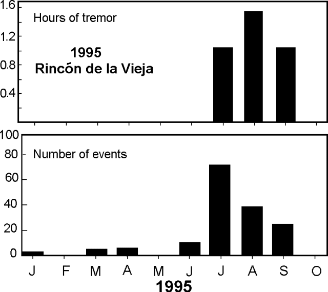 |
Figure 11. Rincón de la Vieja's monthly totals for tremor and low-frequency seismicity, January-September 1995. Courtesy of OVSICORI-UNA. |
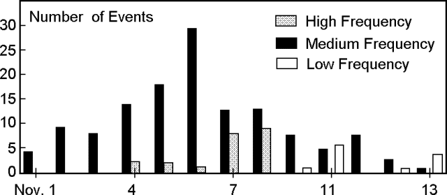 |
Figure 12. Rincón de la Vieja's seismicity, 1-13 November 1995. An eruption began on 6 November. Courtesy of OVSICORI-UNA. |
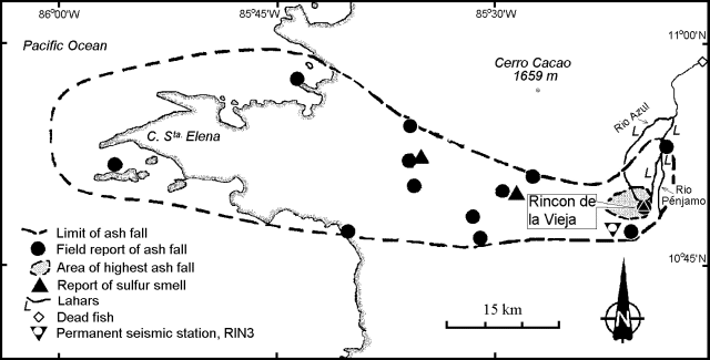 |
Figure 13. Map of NW Costa Rica showing key features associated with Rincón de la Vieja's 6 November 1995 eruption. Courtesy of OVSICORI-UNA. |
The seismic receiver (RIN3) sits 5 km SW of the active crater. Although the OVSCICORI-UNA seismic system failed on 29 October (and possibly other times during the month), it functioned reliably again after the 31st. Low-frequency events gradually increased during 1-6 November (figure 12), followed by a modest decline. High-frequency events were only registered after 3 November. Tremor was absent prior to the 6 November eruption.
OVSCICORI reported that the first phase of the eruption consisted of vapor with subordinate ash in a discharge lasting 2 minutes. Later, vigorous fumarolic activity led to many hours of constant tremor. Only two more clear eruptions followed in the initial 17 hours of venting, but others followed in subsequent days. The eruption climaxed on the morning of the 8th, when columns reached 3.5 km altitude. Fine ash blew W and NW; larger blocks and tephra were confined to within ~1 km and the area of heavy ashfall reached ~5 km away (figure 13).
During some phases of the eruption, lahars flowed down the Azul and Penjamo rivers and an interfluvial ravine called the Quebrada Azumicrorada (figure 13). Upper reaches of these drainages sustained up to 6 m of erosion. Lahars on the 7th were cooler and more water-rich than those on the 8th. In addition to previously reported damage, on 8 November lahars shut down some communications systems.
At 0900 and 1130 on 8 November OVSICORI scientists visited the summit area and saw impact craters as large as 2 m in diameter; the craters were produced by 0.5-1.0 m diameter blocks, some of which were still warm to the touch. The scientists also saw ongoing phreatic eruptions escaping from a vent adjacent to the crater lake.
At 0411 on the 9th a shock wave was felt 25 km SE in the city of Liberia; the related outburst was seen from the N flank, where residents witnessed incandescent block ejections.
Amplitudes on the seismic recorders regularly peaked at over 30 mm on 6-9 November. The highest amplitudes, on 7-9 November, reached nearly 60 mm. Amplitudes decreased the morning of 9 November; following the eruption (10-14 November) amplitudes generally remained under 10 mm with infrequent spikes to ~20 mm and a few rare spikes to 30 mm. Tremor decreased by an order of magnitude on 10 November and it dropped to <1 hour/day on 13 November.
During fieldwork in early December, G. Soto (ICE) and G. Boudon (IPG) inspected the near-source region. For a radial distance of ~1 km from the crater they saw a deposit consisting of muddy ash, lapilli, and blocks. These reached 40 cm thick on the crater's southern outer rim at a point 150 m from the inner rim. The deposit's thickness and grain size decreased rapidly with distance, such that at 600 m SW of the crater the deposit was only 7 cm thick. The deposit's basal zone was enriched in fine grained, muddy-looking material, but throughout the deposit there occurred lustrous black juvenile clasts. Over ~1 km2 of the upper surface of the deposit, there lay a blanket consisting of (a) dense, quenched blocks, (b) breadcrust bombs with notably vesicular cores, and (c) some highly vesiculated fragments. On 8 December at points 5 and 8 km from the summit, the Penjama and Blanco rivers, respectively, still ran milky and were slightly acidic in taste. That same day, the scientists saw only fumarolic activity. Although scientists looked for a lake in the depths of the crater, they failed to gain a clear view there.
Reference. Boudon, G., Rancon J.-P., Kieffer, G., Soto, G.J., Traineau, H., and Rossignol, J.-C., 1995, Estilio eruptivo actual del Volcan Rincón de la Vieja: evidencias de las productos de las erupciones de 1966-70 y 1991-92: Rothschildia, 2 (2): 10-13, Area de conservacion de Guanacaste, Costa Rica.
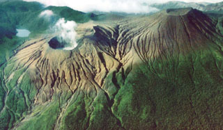
Geological Summary. Rincón de la Vieja, the largest volcano in NW Costa Rica, is a remote volcanic complex in the Guanacaste Range. The volcano consists of an elongated, arcuate NW-SE-trending ridge constructed within the 15-km-wide early Pleistocene Guachipelín caldera, whose rim is exposed on the south side. Sometimes known as the "Colossus of Guanacaste," it has an estimated volume of 130 km3 and contains at least nine major eruptive centers. Activity has migrated to the SE, where the youngest-looking craters are located. The twin cone of Santa María volcano, the highest peak of the complex, is located at the eastern end of a smaller, 5-km-wide caldera and has a 500-m-wide crater. A Plinian eruption producing the 0.25 km3 Río Blanca tephra about 3,500 years ago was the last major magmatic eruption. All subsequent eruptions, including numerous historical eruptions possibly dating back to the 16th century, have been from the prominent active crater containing a 500-m-wide acid lake located ENE of Von Seebach crater.
Information Contacts: E. Fernandez, E. Duarte, R. Sáenz, W. Jimenez, and V. Barboza, Observatorio Vulcanológico y Sismológico de Costa Rica, Universidad Nacional (OVSICORI-UNA), Apartado 86-3000, Heredia, Costa Rica; Georges Boudon, Institut de Physique du Globe de Paris, 4, Place Jussieu, 75252, Paris Cedex 05, France.