Report on North Gorda Ridge Segment (United States) — February 1996
Bulletin of the Global Volcanism Network, vol. 21, no. 2 (February 1996)
Managing Editor: Richard Wunderman.
North Gorda Ridge Segment (United States) Eruption or intrusive event detected by acoustic signals
Please cite this report as:
Global Volcanism Program, 1996. Report on North Gorda Ridge Segment (United States) (Wunderman, R., ed.). Bulletin of the Global Volcanism Network, 21:2. Smithsonian Institution. https://doi.org/10.5479/si.GVP.BGVN199602-331031
North Gorda Ridge Segment
United States
42.67°N, 126.78°W; summit elev. -3000 m
All times are local (unless otherwise noted)
In late February and early March a possible submarine eruption was detected on the Gorda Ridge. Seismo-acoustic T-waves established the epicenter at between 42.41 and 42.75°N. Vertical conductivity-temperature-depth (CTD) casts found a candidate plume at 42.67°N, 126.78°W.
Beginning at 0700 GMT on 28 February, intense seismicity was detected using the T-phase Monitoring System developed by National Oceanic and Atmospheric Administration's Pacific Marine Environmental laboratory (NOAA/PMEL) to access the U.S. Navy's Sound Surveillance System (SOSUS) in the NE Pacific. The event was located on the northernmost segment of the Gorda Ridge (figure 1), over 200 km W of the Oregon coast. The seismicity was very similar to that observed in June 1993 at the CoAxial Segment of the Juan de Fuca Ridge at 46.5°N (BGVN 18:07), which was later documented to be the lateral injection of magma with a subsequent eruption.
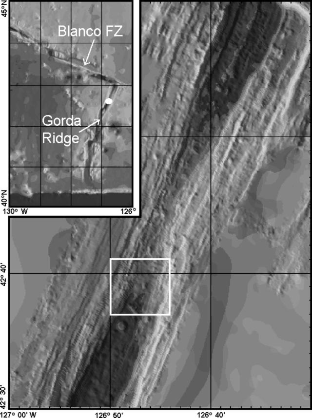 |
Figure 1. Bathymetric map of the northernmost Gorda Ridge, NE Pacific Ocean. White box shows the approximate area of the hydrothermal plumes found during 10-11 March 1996. The "narrow-gate" summit area is located just N of the plume location, around 42.75°N, 126.75°E. Inset bathymetric map shows the Blanco Fracture Zone and the Gorda Ridge, with the eruption site indicated by a white dot. Courtesy of the RIDGE Office. |
For the first 42 hours of T-wave seismicity, two proximal SOSUS arrays were not operating, so the presence of seismicity in the general area of the northern Gorda Ridge was confirmed based on distant arrays. The proximal SOSUS array became operational on 6 March, allowing improved sensitivity and epicenter estimates. Seismicity continued during 6-8 March, located thoughout the S half of the ridge segment from 42°25' to 42°45'N.
The Gorda Ridge Eruption Assessment Team (GREAT), aboard the NOAA Ship MacArthur, reached the area on 8 March. They began a series of vertical CTD casts starting at 42°26.2'N, 126°55.3' W, and proceeding N along the ridge axis with measurements at ~2' intervals; only 2,900 m of wire was useable. No plume signals were detected on the first six casts, although up to 1 km of the water column remained below the deepest CTD depths reached. At 42°37.9'N, 126°47.8'W, temperature and particle plumes were found between 1,850 and 2,800 m above a bottom depth of 3,300 m. The main plume lens was centered at 1,850-2,300 m, with several thinner and less intense plumes below. Plume distribution was similar at the next two stations N, though the overall plume became thinner and less intense. A plume located 24 hours later was similar, perhaps indicating advection of the plume to the W.
On 9 March seismicity decreased to <10 events/hour. Only minor seismic activity was recorded on 10 March, mostly from the shallower "narrow-gate" (summit) area near 42°45'N. That day, GREAT detected a large hydrothermal plume centered near 42°40'N, 126°47'W that may have been due to recent magmatic activity. Initial survey work indicated that the plume may have been an agglomeration of more than one discharge. It had a maximum thickness of ~700 m, a maximum diameter of ~10 km, and a maximum temperature anomaly of ~0.12°C. Seismicity continued at a low level (<5 earthquakes/hour) during 11-14 March. Seismic activity increased again at 1625 GMT on 15 March to >25 events in the first hour. The nature of the seismicity appeared to be due to magma injection rather than eruption. Preliminary locations for the 15 March activity were in the summit area.
Based on their exceptional height above the axial valley, most of the major plumes detected through 15 March were thought to be event plumes. The capability to demonstrate the vertical and horizontal symmetry characteristic of event plumes was not available. Apparently, several distinct event plumes were mapped that differ in depth and in horizontal and vertical dimensions. One alternative hypothesis is that all, or some, of the plumes are chronic plumes originating high on the valley walls. No substantial near-seafloor plumes have been found. The source of the presumed event plumes may be S of their present position in water too deep for available equipment to reach, farther to the N where samples had not yet been taken, or beneath their present position but as yet undetected.
Remaining unanswered questions regarding the Gorda Ridge event, as well as mid-ocean ridge events generally include: spatial and temporal patterns of seismicity, intrusive vs. extrusive behavior, the origin of the event plumes, and patterns and rates of geochemical and microbiological processes associated with event plumes and resulting chronic plumes. A second response cruise on the UNOLS RV Wecoma during the first two weeks of April 1996 will focus on water column work and camera tows.
Substantial data sets have been previously collected in this area. Water column surveys collected by NOAA in 1985 and later surveys by Oregon State University showed water column temperature anomalies in the area, which was labelled GR-14. Full SeaBeam coverage has been collected by NOAA. SeamarC II surveys were collected in the area in 1983 by USGS/University of Hawaii. Detailed SeamarC I surveys were collected by NOAA/PMEL in the northern half of the segment in 1987. Camera surveys were conducted in 1985-86 by USGS and NOAA/PMEL. Extensive dredges were also collected by USGS. The Navy's SeaCliff submersible dove in the area in 1988.
Geological Summary. The northernmost of five segments of the Gorda Ridge lies immediately south of the Blanco Transform Fault that offsets the Gorda and Juan de Fuca oceanic spreading ridges. The 65-km-long segment is located about 200 km W of the southern Oregon coast and has deep 5- 10-km-wide valleys at either ends with a shallower narrow axial valley at the center. This morphology, which in plan view resembles an hourglass, is typical of magmatically active spreading segments. A submarine lava flow was erupted in late February and early March 1996, near the center of the segment. The eruption was initially detected through acoustic T-waves from a seismic swarm and the emission of large thermal plumes. In April submarine cameras revealed new lava flows about 100-200 m wide along a fissure that was at least 3.5 km long. A seismic swarm of uncertain origin also occurred at this location in January 1998.
Information Contacts: Chris Fox, Bob Embley, Bob Dziak, and Ed Baker, NOAA Pacific Marine Environmental Laboratory, 2115 SE Osu Drive, Newport, OR 97365 USA (URL: http://www.pmel.noaa.gov); RIDGE Office, Ocean Processes Analysis Laboratory, Morse Hall, 39 College Road, University of New Hampshire, Durham, NH 03824-3525 USA (URL: http://ridge.unh.edu).