Report on Popocatepetl (Mexico) — February 1996

Bulletin of the Global Volcanism Network, vol. 21, no. 2 (February 1996)
Managing Editor: Richard Wunderman.
Popocatepetl (Mexico) New eruptive episode produces ash plume that drifts over SW coast
Please cite this report as:
Global Volcanism Program, 1996. Report on Popocatepetl (Mexico) (Wunderman, R., ed.). Bulletin of the Global Volcanism Network, 21:2. Smithsonian Institution. https://doi.org/10.5479/si.GVP.BGVN199602-341090
Popocatepetl
Mexico
19.023°N, 98.622°W; summit elev. 5393 m
All times are local (unless otherwise noted)
An ash-emission event was detected at 0349 on 5 March when continuous tremor began. This seismicity remained at relatively high levels for about one hour, and then decreased. Mild ashfalls were reported in the immediate area around the volcano, particularly in the N sector. During a helicopter reconnaissance flight at 1200, ash deposits were confirmed, especially in the close neigborhood of Tlamacas (figure 12). The glacier and snow near the summit were entirely covered by ash, confirming statements made by witnesses who saw ash emissions in the morning. A vigorous ash-and-gas column could be seen rising ~800 m vertically; it dispersed NE in a long plume. A sulfur smell could clearly be perceived near the crater. The emission of gas, steam, and ash appeared to come from the same three sources in the E side of the crater that produced the 1994-95 activity (BGVN 19:11, 19:12, and 20:01-20:04). This event on 5 March seemed very similar to that of 21 December 1994, but perhaps about an order of magnitude lower, an intensity comparable to the levels of activity observed on 26 December 1994. The only activity that may be regarded as precursory was a small A-type event at 0227 (M 1.2).
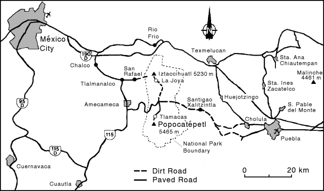 |
Figure 12. Base map of Popocatépetl and vicinity (elevations taken from the 1986 México City 1:250,000 topographic sheet). |
Tremor activity slowly decreased through the night of 5-6 March. At 0710 on 6 March another sudden increase in the gas and ash emission rates was accompanied by tremor signals comparable to those of the previous day. These levels persisted through at least 1030 on 6 March. During a second helicopter reconnaissance flight, between 0825 and 0930, the ash plume was larger than the previous day, and directed E. However, the plume, consisting of steam, gases, and dilute fine-grained ash, bent as it exited the crater. Considering the low wind speed at the summit (~28 km/hour), this suggested a low thermal power in the emission.
At 1245 on 6 March a new and stronger ash-emission event was detected. Volcanic tremor increased correspondingly. Tremor amplitude continued to increase until 1532, when it reached the relatively high levels of early 5 March, where it remained for at least three hours. The ash plume, now with a higher particle density, was blown SE at ~22 km/hour. Besides tremor, during the first two days of the eruption there were mixed low-magnitude A- and B-type earthquakes at shallow to intermediate depths, with the greatest concentration at ~5-9 km beneath the summit (figure 13).
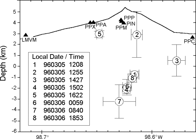 |
Figure 13. Cross-section of earthquake hypocenters at Popocatépetl during 5-7 March 1996. Triangles indicate the position of seismic stations. Bars indicate uncertainties in the location. All dates and times are local. Courtesy of Carlos Valdes-Gonzalez, UNAM. |
Volcanic tremor amplitude and the ash emission rate remained fairly constant until 1030 on 7 March, when tremor amplitudes decreased by a factor of about two. However, a helicopter flight at 0800-0900 showed some increase in the apparent emission rate. Mild ashfall on the volcanoþs flank was observed under the plume; wind speed was low (10-12 km/h). These conditions remained stable until 7 March at 1650, when tremor amplitude and duration increased to levels exceeding those of December 1994. Stronger winds (60 km/hour at 1100) bent the plume horizontally from the crater, dispersing the ash farther E. Tiltmeters showed some oscillations, probably related to the high tremor level, but no actual deformation was detected. High tremor amplitudes persisted until 1400 on 10 March, when tremor amplitude and the ash emission rate slowly underwent a 5-fold decrease.
Low-level activity persisted until 11 March at 1800, with three important exceptions. At 1845 on 10 March, a strong emission produced an ash column nearly 3 km high accompanied by a small 2-minute duration B-type volcanic earthquake. These events repeated at 0921 and 0937 on 11 March. The 0921 event was preceded by a fairly high-frequency A-type earthquake at 0906. On 11 March at 1800, the pattern of activity started to return to continuous tremor and ash emission. These tremor signals have been interpreted as high-speed exhaust of volcanic gases that remobilize non-juvenile ash.
Satellite imagery, 10-11 March. Analysis of satellite imagery by the NOAA Synoptic Analysis Branch revealed that an eruption at 0245 on 10 March was followed 30 minutes later by a larger burst. The height of the ash was estimated to be just above the summit level (5.5 km). By 1315 that day the ash plume had extended S and SW as far as the Pacific Ocean (figure 14a). Movement of the ash cloud by 1515 suggested that the ash probably extended upwards to ~7 km. The last usable visible imagery on 10 March (at 1815) showed the thicker portion of the ash cloud over the ocean (figure 14b), but less ash in the immediate vicinity of the volcano. This correlates with the decrease in tremor amplitude and ash emission that began at 1400 as noted above. However, infrared imagery indicated continued eruptive activity through the night.
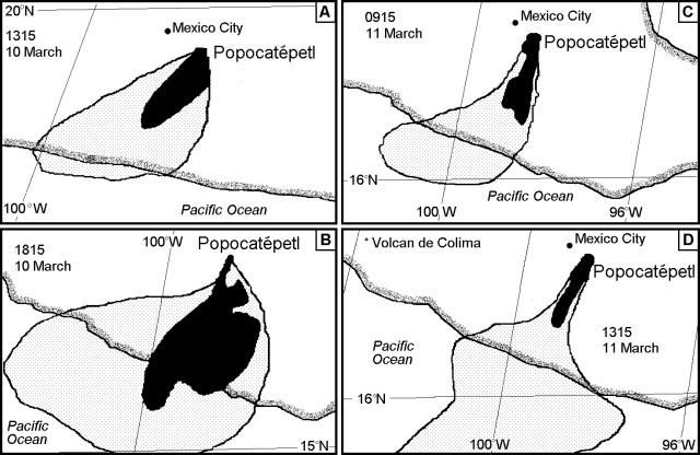 |
Figure 14. Sketches of the ash plumes from Popocatépetl based on visible satellite imagery, 11-12 March 1996. Solid areas are denser zones of the eruption cloud, lightly stippled areas are zones of the cloud with less ash. Note that scales vary. Courtesy of the NOAA Synoptic Analysis Branch. |
The first visible imagery the next morning, at 0915, showed the volcano still erupting with the ash moving S and then W over the East Pacific Ocean (figure 14c), possibly with thinner ash even farther away. A stronger eruptive event at 0945 (probably the 0921 and 0937 events as noted above) sent a plume to perhaps 7.5 km altitude where it was blown SE. The cloud from these events had dissipated by the time of the next visible image at 1015. Eruptions became intermittent over the next three hours, with the estimated plume height remaining at ~7 km altitude. Ash seen on imagery at 1315 was present in a very narrow S-directed area (figure 14d), with thinner ash detected over the ocean.
Geological Summary. Volcán Popocatépetl, whose name is the Aztec word for smoking mountain, rises 70 km SE of Mexico City to form North America's 2nd-highest volcano. The glacier-clad stratovolcano contains a steep-walled, 400 x 600 m wide crater. The generally symmetrical volcano is modified by the sharp-peaked Ventorrillo on the NW, a remnant of an earlier volcano. At least three previous major cones were destroyed by gravitational failure during the Pleistocene, producing massive debris-avalanche deposits covering broad areas to the south. The modern volcano was constructed south of the late-Pleistocene to Holocene El Fraile cone. Three major Plinian eruptions, the most recent of which took place about 800 CE, have occurred since the mid-Holocene, accompanied by pyroclastic flows and voluminous lahars that swept basins below the volcano. Frequent historical eruptions, first recorded in Aztec codices, have occurred since Pre-Columbian time.
Information Contacts: Servando De la Cruz (CENAPRED and Instituto de Geofisica, UNAM); Roberto Quaas, Enrique Guevara, Bertha López, Alicia Martínez, and Carlos Gutierrez, Centro Nacional de Prevencion de Desastres (CENAPRED), México; Claus Siebe, Instituto de Geofisica, UNAM, Coyoacán 04510 DF, México; Carlos Valdes-Gonzalez, Depto de Sismología y Volcanología, Instituto de Geofísica, UNAM, Ciudad Universitaría 04510 DF, México; Jim Lynch, NOAA/ NESDIS Synoptic Analysis Branch, Room 401, 5200 Auth Road, Camp Springs, MD 20746, USA.