Report on Pinatubo (Philippines) — March 1996

Bulletin of the Global Volcanism Network, vol. 21, no. 3 (March 1996)
Managing Editor: Richard Wunderman.
Pinatubo (Philippines) Rainfall during October-November 1995 typhoons generates floods and lahars
Please cite this report as:
Global Volcanism Program, 1996. Report on Pinatubo (Philippines) (Wunderman, R., ed.). Bulletin of the Global Volcanism Network, 21:3. Smithsonian Institution. https://doi.org/10.5479/si.GVP.BGVN199603-273083
Pinatubo
Philippines
15.13°N, 120.35°E; summit elev. 1486 m
All times are local (unless otherwise noted)
Intense and prolonged rainfall, associated with the passage of two typhoons on 1 October and 3 November 1995, triggered lahars and floods along the Pasig-Potrero River.
On 1 October 1995, Typhoon Mameng delivered 337 mm of rain on the Sacobia pyroclastic fan triggering five distinct and fairly continuous lahar episodes over a 14-hour period. The largest episode had an estimated peak discharge of 400 m3/sec at Mancatian, Porac. Within each episode were discrete peak readings that could be generated by several causes: variations in rainfall intensity and duration, bank caving, repeated damming and breaching along channel constrictions, as well as any combination of these. Flows were described as steaming at observation point Delta 5 (15.5 km from Pinatubo), but progressive dilution through the incorporation of older materials cooled the flows to ambient temperature by the time they reached Bacolor.
The Typhoon Mameng deposit can be distinguished from earlier lahar deposits by the abundance of pebble to boulder-size clasts rip-ups of older, pre-1991, eruption materials scoured from the channel. The Mameng deposit was provisionally classified in two distinct debris flow units: a gray pumiceous, pebbly sand unit (A), and a brown, lithic-rich, coarse gravel unit (B). Unit A occurs as small overbank deposits at Mancatian, and as laterally extensive coalescing lobes from San Antonio, Bacolor down to the Gapan-San Fernando-Ologampo (GSO) road. Its occurrence as an overbank facies at Mancatian suggests that this unit correlates to the above mentioned peak flow episode. Unit B corresponds to subsequent flows and waning episodes: it occurred as in-channel, gravel terrace deposits from Delta 5 observation point downstream to the GSO road, and from thereon as an overbank facies where it overlaid unit A.
A total area of 25 km2 was buried beneath 0.5 to 6 m thick of sediment. An estimated sediment volume of 50 x 106 was deposited during these events, with roughly 40% consisting of either old, pre-1991 eruption deposits or post-1991 eruption lahar materials.
On 3 November 1995, 150 mm of rain fell on Mount Pinatubo with the passage of Typhoon Rosing. Lahars observed at Delta 5 watch point were relatively cold hyperconcentrated flows, based on the absence of steaming. Estimated peak discharge was about 120 m3/sec. Based on flow sensor data from the Pasig-Potrero river, the peak flow was channel-confined down to the GSO road and lasted ~2.6 hours. It eroded ~30 m of the left bank along the Porac-Angels Road. Sediments were mostly clayey remobilized Mameng deposits.
Former flows had already filled the stretch of the channel at a point 2 km upstream of the GSO road down to the S portion of Bacolor. When the peak flow reached the channel-filling stage, it caused flows to bifurcate and incise a new channel (figure 34) ~50 m W of the typhoon Mameng channel. Average in-channel deposition was 2 m thick; average overflow deposition, ~0.3-m thick. Overflow units were observed along the banks of the previous channel along the GSO road and leveled to a recently emplaced steel bridge. Flows reached farther downstream causing flooding and siltation near Mesalipit and Tinajeros. The other channel backflowed following considerable aggradation along the GSO road. The new channel delivered muddy flows that induced flooding and siltation in the W portion of San Fernando, particularly in the Barangays of St. Nino and St. Lucia.
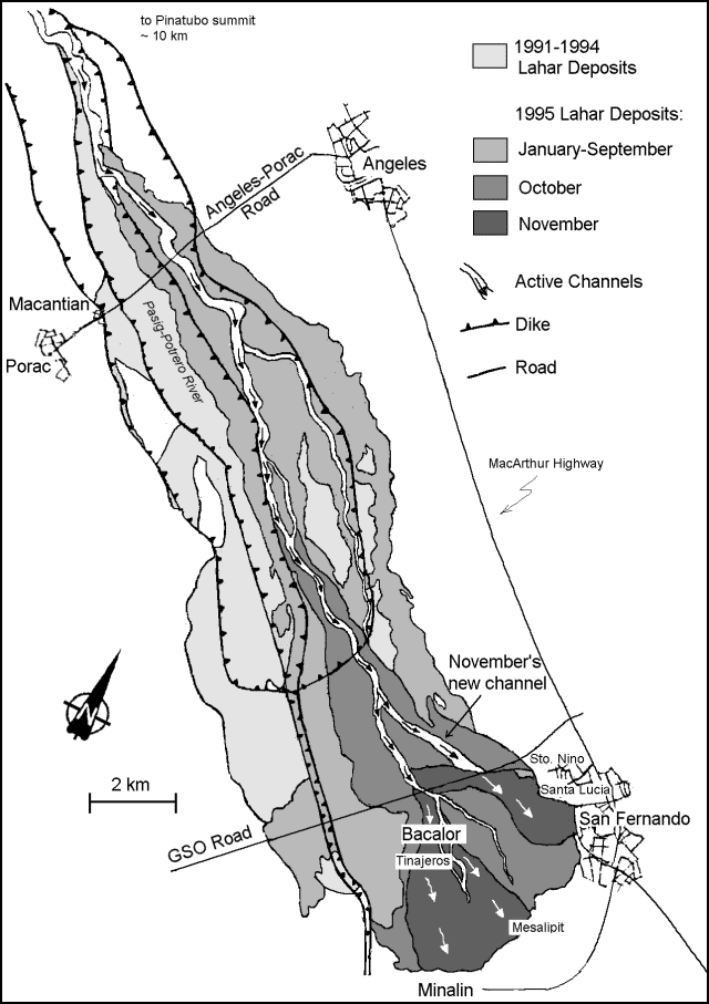 |
Figure 34. Map of the 1991-95 lahars at Pinatubo. Courtesy of PHIVOLCS. |
Lahars have occurred during every rainy season since the eruption of 15 June 1991. Pinatubo's last reported lahars were triggered by the heavy rainfalls of July 1995, when 30 x 106 m3 of debris, deposited over a 12 km2 area, forced mass evacuation of Porac and Bacalor (BGVN 20:07).
Geological Summary. Prior to 1991 Pinatubo volcano was a relatively unknown, heavily forested lava dome complex located 100 km NW of Manila with no records of historical eruptions. The 1991 eruption, one of the world's largest of the 20th century, ejected massive amounts of tephra and produced voluminous pyroclastic flows, forming a small, 2.5-km-wide summit caldera whose floor is now covered by a lake. Caldera formation lowered the height of the summit by more than 300 m. Although the eruption caused hundreds of fatalities and major damage with severe social and economic impact, successful monitoring efforts greatly reduced the number of fatalities. Widespread lahars that redistributed products of the 1991 eruption have continued to cause severe disruption. Previous major eruptive periods, interrupted by lengthy quiescent periods, have produced pyroclastic flows and lahars that were even more extensive than in 1991.
Information Contacts: Raymundo S. Punongbayan, director, Philippine Institute of Volcanology and Seismology (PHIVOLCS), Department of Science and Technology, (DOST), 5th & 6th Floors Hizon Building, 29 Quezon Avenue, Quezon City, Philippines.