Report on Nevado del Ruiz (Colombia) — May 1996

Bulletin of the Global Volcanism Network, vol. 21, no. 5 (May 1996)
Managing Editor: Richard Wunderman.
Nevado del Ruiz (Colombia) Earthquake swarms during July-September 1995 and January-April 1996
Please cite this report as:
Global Volcanism Program, 1996. Report on Nevado del Ruiz (Colombia) (Wunderman, R., ed.). Bulletin of the Global Volcanism Network, 21:5. Smithsonian Institution. https://doi.org/10.5479/si.GVP.BGVN199605-351020
Nevado del Ruiz
Colombia
4.892°N, 75.324°W; summit elev. 5279 m
All times are local (unless otherwise noted)
Almost two years of low-level seismicity ended in mid-March 1994 with the occurrence of a high-frequency earthquake swarm followed by long-period events and an explosion on 23 April (BGVN 19:05). Activity returned to low levels through the rest of 1994.
A mid-sized landslide in January 1995 descended the upper reach of the Lagunillas River but caused no significant damage. It was primarily caused by ground and ice-cap instability, not volcanism. Seismicity in July and August 1995 was stronger than in April 1994. Swarms of long-period events reached a maximum count of 1,050 events on 26 July with more than 6.3 x 10⁸ ergs of energy released. Some of the events were related to explosions heard by scientists doing fieldwork some kilometers away from the Arenas Crater, but ash emission was not confirmed. No significant volcano-tectonic activity was registered. Swarms of long-period events during early September 1995 were similar to those of July-August, but were fewer in number and had less energy. This volcanic related seismicity was located mostly toward the Arenas Crater and the SW part of the volcano at shallow depths.
Seismicity during January-April 1996 remained low, except for the first 10 days of January when there was an increase of long-period screw-type events, with a high of seven on the 5th. Most of these events were located at shallow depths near Arenas Crater and over its W side. Screw-type events have become significant since May 1995. Some volcano-tectonic earthquake swarms also occurred during these four months. Two significant swarms were located toward the S part of the volcano, near the RECI seismic station (figure 47). In both swarms, maximum magnitudes were close to 3. Tremor signals were intermittent; some saturated the stations closest to Arenas Crater, but none were correlated to ash emissions. The electronic tiltmeter 800 m from Arenas Crater (FARA) did not show significant variations. During these four months there were a total of 657 volcano-tectonic earthquakes and 1,308 long-period events recorded by the observatory network. This suggests that processes related to fluids within the volcanic conduits were dominant over fracture-related processes.
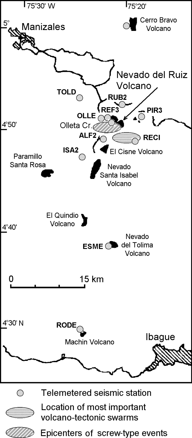 |
Figure 47. Location of telemetered stations and significant seismic events recorded at Ruiz during January-April 1996. Courtesy of INGEOMINAS. |
Nevado del Ruiz, located 33 km SE of Manizales, is a broad stratovolcano of andesitic and dacitic lavas and andesitic pyroclastic deposits that cover more than 200 km2. Steep headwalls of massive landslides cut its flanks, and melting of its summit ice cap during historical eruptions resulted in devastating lahars. The last eruption began with moderate phreatic ejections on 11 September 1985. On 13 November 1985 an explosive eruption produced pyroclastic flows and surges that melted part of the summit ice cap. Major mudflows subsequently devastated Armero and other towns on the flanks of the volcano, causing over 23,000 fatalities. Intermittent minor ash emissions with occasional stronger phreato-magmatic eruptions continued until July 1991.
Geological Summary. Nevado del Ruiz is a broad, glacier-covered volcano in central Colombia that covers more than 200 km2. Three major edifices, composed of andesitic and dacitic lavas and andesitic pyroclastics, have been constructed since the beginning of the Pleistocene. The modern cone consists of a broad cluster of lava domes built within the caldera of an older edifice. The 1-km-wide, 240-m-deep Arenas crater occupies the summit. The prominent La Olleta pyroclastic cone located on the SW flank may also have been active in historical time. Steep headwalls of massive landslides cut the flanks. Melting of its summit icecap during historical eruptions, which date back to the 16th century, has resulted in devastating lahars, including one in 1985 that was South America's deadliest eruption.
Information Contacts: John Jairo Sánchez A., Fernando Gil Cruz, Alvaro Pablo Acevedo, John Makario Londoño, and Jairo Patiño Cifuentes, INGEOMINAS Observatorio Vulcanológico y Sismológico de Manizales (OVSM), A.A. 1296, Manizales, Caldas, Colombia.