Report on Yasur (Vanuatu) — August 1996

Bulletin of the Global Volcanism Network, vol. 21, no. 8 (August 1996)
Managing Editor: Richard Wunderman.
Yasur (Vanuatu) Continued Strombolian eruptions ejecting bombs at ~150 m/second
Please cite this report as:
Global Volcanism Program, 1996. Report on Yasur (Vanuatu) (Wunderman, R., ed.). Bulletin of the Global Volcanism Network, 21:8. Smithsonian Institution. https://doi.org/10.5479/si.GVP.BGVN199608-257100
Yasur
Vanuatu
19.532°S, 169.447°E; summit elev. 361 m
All times are local (unless otherwise noted)
The very intense activity recorded throughout 1994 (BGVN 20:08) decreased in 1995. Observations during a visit on 7 November 1995 showed that the volcano had returned to a "normal" level of activity, consisting of explosions, lava fountaining, and ash emissions. Approaching Yasur is always dangerous because the trajectories of volcanic bombs are unpredictable; acoustic and optical measurements have revealed that some bombs have initial ejection velocities of ~150 m/second.
A permanent telemetered seismic monitoring station located 2 km from the summit has been in operation since 1993. The majority of recorded signals correspond directly to volcanic explosions. High seismicity corresponding to the elevated level of volcanism during 1994 (figure 5) decreased throughout 1995.
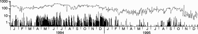 |
Figure 5. Daily seismicity at Yasur recorded by the seismometer 2 km from the summit, 1994-95. The upper line shows all events with a seismograph displacement greater than 12 µm. The bars indicate the number of larger events, those with a displacement greater than 60 µm. Note that the scale is logarithmic. Courtesy of ORSTOM. |
Geological Summary. Yasur has exhibited essentially continuous Strombolian and Vulcanian activity at least since Captain Cook observed ash eruptions in 1774. This style of activity may have continued for the past 800 years. Located at the SE tip of Tanna Island in Vanuatu, this pyroclastic cone has a nearly circular, 400-m-wide summit crater. The active cone is largely contained within the small Yenkahe caldera, and is the youngest of a group of Holocene volcanic centers constructed over the down-dropped NE flank of the Pleistocene Tukosmeru volcano. The Yenkahe horst is located within the Siwi ring fracture, a 4-km-wide open feature associated with eruption of the andesitic Siwi pyroclastic sequence. Active tectonism along the Yenkahe horst accompanying eruptions has raised Port Resolution harbor more than 20 m during the past century.
Information Contacts: M. Lardy and D. Charley, Centre ORSTOM, BP 76, Port Vila, Vanuatu, and Départment des Mines et de la Géologie et des Ressources en Eaux; J. Tabbagh, Centre de Téléobservation Informatisé des Volcans, CNRS-CRG, Garchy, France; S. Vergniolle, Institut de Physique du Globe, Paris, France; J-P. Eissen, Centre ORSTOM de Brest, BP 70, 29280 Plouzane, France; C. Robin and M. Monzier, Centre ORSTOM, Apartado 17-11-6596, Quito, Ecuador.