Report on Pavlof (United States) — September 1996
Bulletin of the Global Volcanism Network, vol. 21, no. 9 (September 1996)
Managing Editor: Richard Wunderman.
Pavlof (United States) Increasing seismicity corresponds to stronger eruptive activity
Please cite this report as:
Global Volcanism Program, 1996. Report on Pavlof (United States) (Wunderman, R., ed.). Bulletin of the Global Volcanism Network, 21:9. Smithsonian Institution. https://doi.org/10.5479/si.GVP.BGVN199609-312030
Pavlof
United States
55.417°N, 161.894°W; summit elev. 2493 m
All times are local (unless otherwise noted)
Residents of the Alaska Peninsula observed small glowing plumes from Pavlof on 15 September. During the next week, seismicity was vigorous and eruptions were intermittent (BGVN 21:08). At 1328 on 24 September seismicity began to increase, suggesting stronger eruptive activity. This increased level of seismicity persisted through the first half of October. Visual observations and satellite imagery verified that increased seismicity correlated with eruptions of ash and bombs up to 1,200 m above the summit.
On 26 September satellite imagery showed a small steam-and-ash plume extending ~45 km SE. A pilot subsequently reported a steam plume to an estimated altitude of 3,700 m. AVO staff doing airborne observations during 27-30 September reported low-level fountaining and occasional small explosions of incandescent material in the summit crater. The small explosions produced sporadic steam-and-ash plumes to 610 m above the vent. The largest plume drifted S for ~110 km and appeared faintly on satellite images. Incandescent spatter was deposited on the NW summit slope or moved down a deep gully on the NW side of the volcano.
During 4-11 October lava fountaining from two vents continued to heights of a few hundred meters above the summit. Incandescent spatter-fed lava flows moved down the steep, snow- and ice-covered slope, widening at the base and extending NW. Occasional water-rich slurries of ash and mud descended the N flank. Diffuse plumes of steam, gas, and ash rose to as high as 6 km above sea level and drifted 160 km downwind. On 15 October eruptive activity increased and seismicity reached the highest levels yet observed. Satellite imagery and pilot reports showed ongoing lava fountaining from two vents near the summit. Pilot reports indicated that diffuse ash layers reached 7,300-m altitude and extended perhaps as far as 50 km SE.
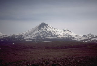
Geological Summary. The most active volcano of the Aleutian arc, Pavlof is a Holocene stratovolcano that was constructed along a line of vents extending NE from the Emmons Lake caldera. Pavlof and Pavlof Sister to the NE form a dramatic pair of symmetrical, glacier-covered stratovolcanoes that overlook Pavlof and Volcano bays. Little Pavlof is a smaller cone on the SW flank of Pavlof volcano, near the rim of Emmons Lake caldera. Unlike Pavlof Sister, eruptions have frequently been reported from Pavlof, typically Strombolian to Vulcanian explosive eruptions from the summit vents and occasional lava flows. The active vents lie near the summit on the north and east sides. The largest recorded eruption took place in 1911, at the end of a 5-year-long eruptive episode, when a fissure opened on the N flank, ejecting large blocks and issuing lava flows.
Information Contacts: Alaska Volcano Observatory (AVO), a cooperative program of a) U.S. Geological Survey, 4200 University Drive, Anchorage, AK 99508-4667, USA (URL: http://www.avo.alaska.edu/), b) Geophysical Institute, University of Alaska, PO Box 757320, Fairbanks, AK 99775-7320, USA, and c) Alaska Division of Geological & Geophysical Surveys, 794 University Ave., Suite 200, Fairbanks, AK 99709, USA.

