Report on Villarrica (Chile) — September 1996

Bulletin of the Global Volcanism Network, vol. 21, no. 9 (September 1996)
Managing Editor: Richard Wunderman.
Villarrica (Chile) Increased seismicity again in late September
Please cite this report as:
Global Volcanism Program, 1996. Report on Villarrica (Chile) (Wunderman, R., ed.). Bulletin of the Global Volcanism Network, 21:9. Smithsonian Institution. https://doi.org/10.5479/si.GVP.BGVN199609-357120
Villarrica
Chile
39.42°S, 71.93°W; summit elev. 2847 m
All times are local (unless otherwise noted)
Above-background seismicity started on 7 September (BGVN 21:08); a follow-up report indicated that Villarrica's microseismicity again increased starting on 26 September and was continuing as late as 3 October. The events seen were of short-duration with dominant frequencies of 1.75 Hz and they appeared in swarms (figure 6). Some isolated events occurred in the 0.7-1 Hz range. In this same time interval the crater was the scene of abundant to occasionally intense degassing.
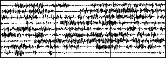 |
Figure 6. One of Villarrica's ongoing swarms of long-period seismic events (station VVN), 0900 to 0927 (GMT) on 26 September 1996. Reference marks are at one minute intervals. Courtesy of Gustavo Fuentealba and Paola Peña. |
Geological Summary. The glacier-covered Villarrica stratovolcano, in the northern Lakes District of central Chile, is ~15 km south of the city of Pucon. A 2-km-wide caldera that formed about 3,500 years ago is located at the base of the presently active, dominantly basaltic to basaltic andesite cone at the NW margin of a 6-km-wide Pleistocene caldera. More than 30 scoria cones and fissure vents are present on the flanks. Plinian eruptions and pyroclastic flows that have extended up to 20 km from the volcano were produced during the Holocene. Lava flows up to 18 km long have issued from summit and flank vents. Eruptions documented since 1558 CE have consisted largely of mild-to-moderate explosive activity with occasional lava effusion. Glaciers cover 40 km2 of the volcano, and lahars have damaged towns on its flanks.
Information Contacts: Gustavo Fuentealba C.1 and Paola Peña, Programa Riesgo Volcánico de Chile (PRV), OVDAS; 1-also at Depto. Ciencias Fisicas, Universidad de La Frontera, Temuco, Chile.