Report on Soufriere Hills (United Kingdom) — September 1996

Bulletin of the Global Volcanism Network, vol. 21, no. 9 (September 1996)
Managing Editor: Richard Wunderman.
Soufriere Hills (United Kingdom) Large destructive explosion 17 September
Please cite this report as:
Global Volcanism Program, 1996. Report on Soufriere Hills (United Kingdom) (Wunderman, R., ed.). Bulletin of the Global Volcanism Network, 21:9. Smithsonian Institution. https://doi.org/10.5479/si.GVP.BGVN199609-360050
Soufriere Hills
United Kingdom
16.72°N, 62.18°W; summit elev. 915 m
All times are local (unless otherwise noted)
The following condenses the weekly Scientific Reports of the Montserrat Volcano Observatory (MVO) and stated sources for the period 1 September-1 October.
Observations during 1-14 September. The early days of the month were characterized by several periods of intense rockfalls and pyroclastic flows from the E flank of the lava dome. The steepening of the dome's active flank caused a partial gravitational collapse on 2 and 3 September. The resulting pyroclastic flows were generally confined to the S part of the Tar River valley although they came from N of Castle Peak (figure 10). The pyroclastic flows caused significant erosion in the middle part of the valley and deposition in the lower part and at the mouth of the Tar River, on the pyroclastic-flow delta built up since late July. Excavation of a deep (>10 m) channel from the base of the new dome through the upper part of the talus fan confined the flows giving them greater run-out potential. The scar left on the E flank was soon refilled by continuous rockfall activity and new dome growth. Samples of the pyroclastic-flow deposits on the delta contained less vesicular material than other deposits since late July, and were typically ash-rich, very poorly sorted, and contained juvenile lava blocks to at least 50 cm diameter.
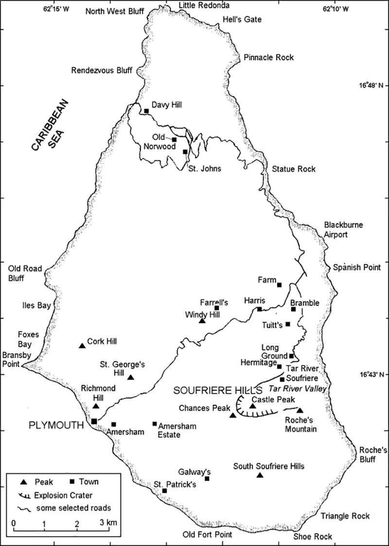 |
Figure 10. Map of Montserrat showing selected towns and features. |
The pyroclastic flows of 2 and 3 September produced ash clouds that rose 6 km, but there was no evidence of vertical columns from the summit of the dome. The ash clouds deposited 1-2 cm of ash in the Cork Hill area, and >5 mm farther N in the Old Towne area. MVO estimated the volume of ash deposited on 2 and 3 September to be equivalent to a rock volume of 7 x 10⁴ m3. In addition to this description from MVO, a local newspaper, The Montserrat Reporter, said these events caused ash to fall on nearly every part of the island from St. Patrick's in the SW, to St. John's in the N, and from Plymouth in the W to Long Ground in the NE, including Bramble Airport. For the remainder of the period, rockfall and associated pyroclastic-flow activity was confined almost exclusively to the E flank. After the major ash falls of 2 and 3 September more moderate amounts were deposited W of the volcano.
Signals from rockfalls and pyroclastic flows dominated the seismic records during this observation period. Long-period and hybrid events remained at background levels and tremor was generally low. Volcano-tectonic earthquakes occurred exclusively in short swarms lasting 1-6 hours. The volcano-tectonic earthquakes were all located <2 km below sea level beneath the crater.
The passage of a hurricane caused several days of strong winds and heavy rain making visual observation of the dome difficult, and causing flash floods that deposited ~60 cm of sediment in Fort Ghaut's lower reaches.
Observations during 15-21 September. Several small pyroclastic flows occurred on 15 September, the largest reaching beyond the Tar River Soufriere. Ash clouds from rockfalls and flows were generally blown NW. Intense ash and steam venting during 1250-1320 on 15 September came from the highest part of the dome W of the active area.
Near-continuous rockfalls started late on the morning of 16 September and by mid-afternoon, numerous pyroclastic flows were being produced by gravitational collapse from the lava dome. Many of these pyroclastic flows reached the sea, extending considerably the depositional fan at the mouth of the Tar River valley. Continuous ash production from the flows fed into a convective column that reached heights of 2-3 km and deposited ash on areas W of the volcano. Activity slowed somewhat in the middle of the evening as pyroclastic flow generation stopped.
Activity restarted at 2342 on 17 September with a small explosive eruption. A laterally directed explosion projected ballistic clasts toward the E (over the Hermitage area and into Long Ground village) and an eruption column was briefly sustained. More than half of the houses in Long Ground were damaged by blocks falling through roofs, doors, and windows. Eight buildings, including the Pentecostal Church, were burnt in Long Ground, all from extremely hot rocks falling on them. The Tar River Estate House was partially demolished by a pyroclastic surge. Gravel-sized material of both pumiceous and dense nature was deposited at Cork Hill, Richmond Hill, and Fox's Bay from the eruption column. The Montserrat Reporter noted that many vehicles had lost their windscreens from "falling pebble rocks". On the other hand, MVO data suggested that the number of windscreen breakages was actually quite low and that ash loading contributed substantially to breakages. All ash erupted during the night was blown W over Plymouth and Richmond Hill and both of these areas received heavy ashfall.
In an electronic forum, Douglas Darby, an eyewitness, reported: "From Iles Bay, you could hear something coming from the direction of the volcano, at about [2345 on 17 September]. It sounded like a low roar, the first time ever in Iles Bay that you could hear any noise from the volcano. Immediately after, thunder and lightning began and it was obvious that this was not anything experienced before . . . And then the rain of stones began . . . Visually you could not really see much at that time but we thought we could see a low level of glowing all across the area where we know is Tar River, from the direction of the pyroclastic flows."
Reports from the NOAA Satellite Analysis Branch indicated that the ash column attained a height of at least 12 km and caused the closure of the airport in Guadeloupe on the morning of 18 September. Pilot and NOAA reports and personal communication with Tom Casadevall indicated that an Air Canada flight inadvertently entered the ash plume on 17 September. Dave Schneider of MTU collected and processed two AVHRR scenes of the ash plume from 18 September: at 0544 the plume was 175 km long E-W and 75 km wide N-S, at 1018 the cloud became very diffuse as it extended 550 km E and 85 km N-S (figure 11).
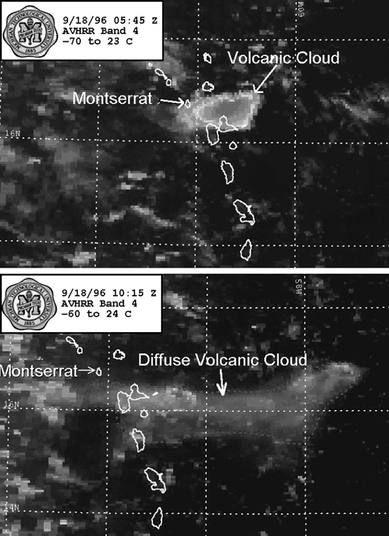 |
Figure 11. AVHRR images of the 18 September ash cloud from Soufriere Hills. Courtesy of Dave Schneider, MTU. |
A major collapse scar cut deeply into the new dome's E flank. Some material was eroded from Castle Peak and a large volume was deposited in the Tar River Valley. The delta at the mouth of the Tar River Valley was enlarged and the vegetation was completely destroyed. MVO estimates stated that perhaps 25-30% of the new dome was removed.
Several small rockfalls from the inner steep-sided walls of the scar, particularly on the N and NW, generated small ash clouds and deposited new debris at the base of the valley. On 19 September field workers found pumice clasts of up to 95 g at 3 km and clasts up to 3.5 g at 6 km. On 22 September a sampling expedition to the Tar River area obtained a temperature of 373°C at a depth of 45 cm in the pyroclastic-flow deposits close to the Tar River Estate House.
Seismicity during this period was characterized by brief swarms of volcano-tectonic earthquakes from a shallow source. These swarms occurred immediately before the most intense rockfalls and increased in frequency and duration preceding the 17-18 September explosion. After 18 September the frequency of volcano-tectonic earthquakes decreased from 2-3 swarms/day to single isolated events at the end of the observation period. Long-period and hybrid events remained low, averaging <11 events/day; low-amplitude tremor was recorded on the Gages seismometer.
Observations during 24-30 September. Activity kept decreasing in intensity during the last part of the month. On 24 September visual observations of the scar's interior showed no signs of new material apart from debris derived from rockfalls off the side walls. Abundant steaming and sulfur deposits were observed at the base of the scar. Rockfalls were very small, mainly concentrated within the scar and associated with continued stabilization of the inner walls of the scar. The lack of large rockfalls suggests that any new dome growth was limited to the interior of the dome, probably at the base of the scar feature caused by the 17 September explosion. On 26 September some red-hot rock and high-temperature gases were seen in the bottom of the scar, suggesting that fresh magma was getting close to the surface again; however material falling from the scar walls covered any new dome growth. Light ashfall, possibly associated with small rockfalls into the scar, was observed by a field team near Chances Peak on 28 September.
On 30 September some areas to the SW and along the base of the scar showed light swelling. This may be due to new dome growth beneath the blocky deposits that line the base of the scar. The N part of the scar had a vertical cliff face with a nearly horizontal, bowl-shaped base, grading downward and outward to the Tar River Valley. Several unstable blocks were observed on the top inner parts of the NE sides of the scar.
Small rockfalls were the most dominant type of seismic signal recorded during this period, but hybrid and volcano-tectonic activity became more prominent during the latter part of the week. Volcano-tectonic earthquakes reappeared from 26 September onwards. They were transitional to hybrid events with a short high-frequency onset and low-frequency coda. The levels of long-period and hybrid events remained comparatively low throughout this period, averaging <11 events/day. Hybrid activity increased somewhat during the latter part of the week in tandem with the increase in volcano-tectonic activity. Tremor levels were high during the earlier parts of the week due to heavy rains. In Fort Ghaut, mudflows resulted from remobilization of thick ash deposits from the 17-18 September explosion.
EDM measurements. Measurements taken on 11 September from White's Yard to Castle Peak showed a 1 cm/day shortening trend, slightly higher than the trend established since mid-July. The Galway's to Chances Peak line was measured on 13 September, but it continued to show inconsistent changes, although shortening was predominant.
On 16 September a shortening of 2.8 cm on the St. George Hill-Farrell's line (N triangle) was measured since 22 August, whereas the two other lines in this triangle -- Windy Hill-Farrell's and St. George's Hill-Windy Hill -- did not change. Between 16 and 21 September the lines St. George's Hill-Farrell's and Windy Hill-Farrell's lengthened by 4 and 9 mm, respectively. These changes, however, are not considered to be related to the 17-18 September explosion. On 25 September the N triangle showed shortening on the St. George Hill-Farrell's and Windy Hill-Farrell's lines of 4 and 11 mm, respectively. Although little consistency is found in the changes of this triangle, a slight overall trend of shortening is observed.
Line lengths between Lower-Upper Amersham and Lower Amersham-Chances Peak showed changes of +48 mm and -1 mm, respectively, during 20-26 September. On 30 September the Galloways-Chances Peak line was found to have lengthened 13 mm during the previous 16 days.
Geological Summary. The complex, dominantly andesitic Soufrière Hills volcano occupies the southern half of the island of Montserrat. The summit area consists primarily of a series of lava domes emplaced along an ESE-trending zone. The volcano is flanked by Pleistocene complexes to the north and south. English's Crater, a 1-km-wide crater breached widely to the east by edifice collapse, was formed about 2000 years ago as a result of the youngest of several collapse events producing submarine debris-avalanche deposits. Block-and-ash flow and surge deposits associated with dome growth predominate in flank deposits, including those from an eruption that likely preceded the 1632 CE settlement of the island, allowing cultivation on recently devegetated land to near the summit. Non-eruptive seismic swarms occurred at 30-year intervals in the 20th century, but no historical eruptions were recorded until 1995. Long-term small-to-moderate ash eruptions beginning in that year were later accompanied by lava-dome growth and pyroclastic flows that forced evacuation of the southern half of the island and ultimately destroyed the capital city of Plymouth, causing major social and economic disruption.
Information Contacts: Montserrat Volcano Observatory (MVO), c/o Chief Minister's Office, PO Box 292, Plymouth, Montserrat (URL: http://www.mvo.ms/); NOAA/NESDIS Satellite Analysis Branch (SAB), Room 401, 5200 Auth Road, Camp Springs, MD 20746, USA; Bennette Roach, The Montserrat Reporter, v. XII nos. 33 and 35, Tom Casadevall, U.S. Geological Survey, Menlo Park, CA 90210 USA; Dave Schneider, Michigan Technological University, Houghton MI 49931, USA; Doug Darby, 6 Satinwood Road, Rocky Point, NY 11778 USA.