Report on Stromboli (Italy) — March 1997
Bulletin of the Global Volcanism Network, vol. 22, no. 3 (March 1997)
Managing Editor: Richard Wunderman.
Stromboli (Italy) Summary of seismic and volcanic activity during May 1996-January 1997
Please cite this report as:
Global Volcanism Program, 1997. Report on Stromboli (Italy) (Wunderman, R., ed.). Bulletin of the Global Volcanism Network, 22:3. Smithsonian Institution. https://doi.org/10.5479/si.GVP.BGVN199703-211040
Stromboli
Italy
38.789°N, 15.213°E; summit elev. 924 m
All times are local (unless otherwise noted)
The following summarizes the interval from 15 May 1996 to 31 January 1997. Eruptive activity increased in mid-April 1996 (BGVN 21:04) and continued through mid-June with significant explosions (BGVN 21:05). A flight on 16 July 1996 documented a plume rising from Stromboli using a Wide Angle Optoelectronic Stereo Scanner (figure 50). This image of the entire island also shows older lava flows, the Sciara del Fuoco, and the Pizzo Sopra La Fossa (120 m above and 250 m SE of the vent), where people often make observations from.
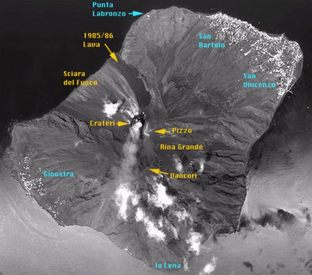 |
Figure 50. Wide Angle Optoelectronic Stereo Scanner (WAOSS) image of Stromboli taken on 16 July 1996. Courtesy of Martin Scheele, DLR. |
Figure 51 illustrates the change in crater morphology between April 1996 and September 1996. Unfortunately the morphological changes in Crater 1 (typically a site of ongoing changes) were obscured on the September stereo photographs; however, the other two craters underwent noteworthy changes. In Crater 3, the front vent (3/3), which was essentially a pit in April, had become a small cone by September as a tephra apron enclosed the vent. In the westernmost part of Crater 3, vents 3/1 and 3/2 merged into a single chasm distinct from the rest of the crater.
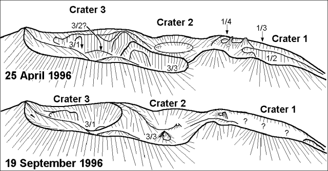 |
Figure 51. Sketches made from terrestrial stereo photographs shot on 25 April 1996 and 19 September 1996. View is towards the NW. The sketches allow comparison of morphological changes in the crater area between these two dates; vents and craters labeled 3/2? and 3/3? were inferred indirectly from ejecta trajectories; areas labeled "?" were obscured by particulate and gases. Courtesy of Jürg Alean (original photos by Alean and Carniel). |
During the first half of August the activity increased at Crater 3, in particular at vent 3/1, where the magma rose to increasingly shallow levels. During 16--17 August 1996, amid vigorous seismicity (figure 52), local volcano guide Nino Zerilli saw a small lava flow discharged from vent 3/1. The lava flow proceeded for only a few meters inside the crater and stopped by the evening of 18 August. Around this same time interval magma also reached high levels in Crater 1.
On 22 August 1996 at 0230 a tourist was hit by volcanic ejecta while in a sleeping bag ~80 m from the crater. He had to be transported by helicopter to Messina for head surgery. Zerilli reported that during the previous days ejecta from Crater 3 had been thrown as far as observation sites between the Pizzo and Crater 3. Thus, this injury appeared to have been more a case of camping too close to the crater rather than an especially violent outburst that particular night.
By 26 August, vent 3/1 was completely inactive, whereas vents 3/2 and 3/3 had almost joined, and their activity consisted of very powerful Strombolian explosions sending small fragments onto the Pizzo. At Crater 1, vent 1/4 only rarely exploded but did so with strong gas jets. In contrast, vent 1/3 ceased the continuous activity that it had begun on 16 April 1996, a change interpreted as either another pause there or the end of an unusually long period of continuous spattering.
On 4 September 1996 at 1545 a blast threw incandescent pyroclastic material onto slope vegetation. This started several fires and the explosion was clearly heard and watched from the village of Stromboli. According to the local newspaper "Il Piccolo" some tourists were caught by the explosion in the crater area and six of them were slightly injured. After this, the Mayor of Lipari ordered the closure of the path to the craters. After the blast, however, Strombolian activity continued to decrease. In terms of seismicity, both the number of major events and the total number of events decreased to very low values, a situation which prevailed through the end of January 1997 (figure 52).
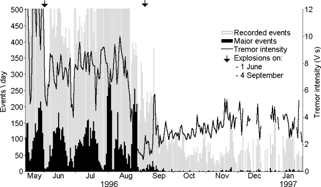 |
Figure 52. Seismicity recorded at Stromboli 15 May 1996-31 January 1997. Open bars show the number of recorded events/day, and the solid bars those saturating the instrument (ground velocity exceeding 100 µm/s). The line shows daily tremor intensity computed by averaging hourly 60-second samples. The seismic station is 300 m from the craters at 800 m elevation. Arrows highlight the two powerful explosions of 1 June and 4 September 1996. Courtesy of R. Carniel. |
A visit by Carniel at the end of September revealed extremely low activity as judged by the few audible eruptions seen or heard; however, smoke often covered most of the crater area. Remarkable were some very long rumbles, which could be heard even from the village of Stromboli. These rumbles were probably associated with strong degassing from Crater 2, although this interpretation remained unconfirmed by direct observation.
Matthias Hort and Ralf Seyfried visited and photographed portions of the volcano during 30 September-2 October (figures 53 and 51). They witnessed small eruptions from vent 2 at Crater 3. These eruptions took place while Craters 1 and 2 were inactive. Rumbling noises heard on 30 September from Crater 1 disappeared within the next two days. Overall, activity gradually declined from 30 September to 2 October. According to Hort, the most spectacular event during the observation period was an ash emission that produced a plume to 100 m above the craters. Periods of up to 2 hours passed without eruption.
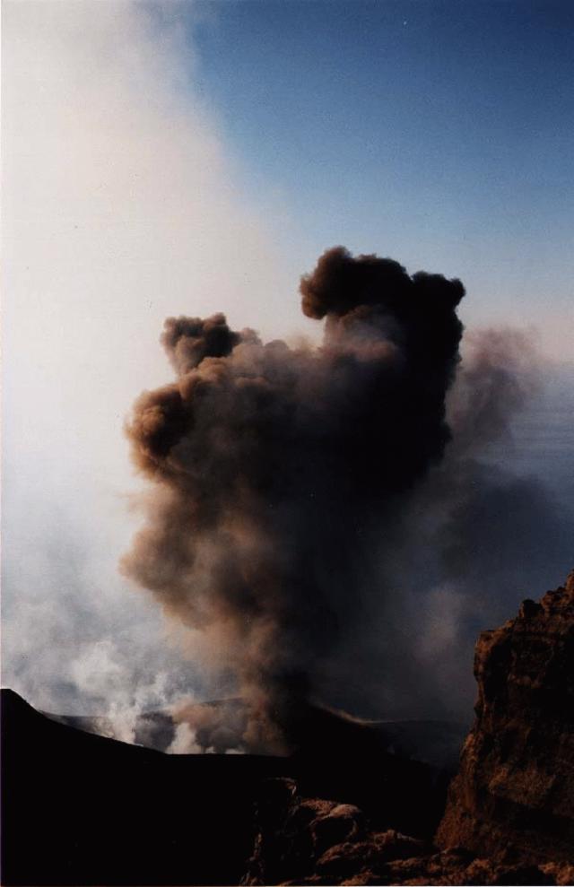 |
Figure 53. Ash and bomb emission from Crater 3 seen from Pizzo on 30 September 1996. Courtesy of Matthias Hort, GEOMAR. |
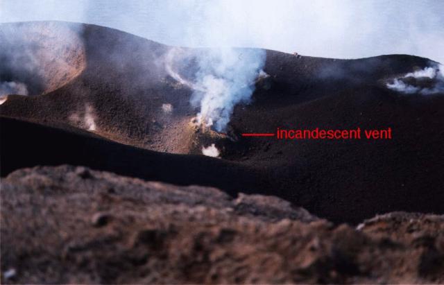 |
Figure 54. View of vent 1 in Crater 3, 30 September 1996. Bright incandescence is seen during daylight, indicating active magma at shallow depth. Courtesy of Matthias Hort, GEOMAR. |
On the evening of 10 October Boris Behncke saw two lava fountains shooting up from Crater 3 during a 5- minute interval, reaching 80-100 m above the vent (to the height of Pizzo sopra la Fossa). Each fountain lasted ~20 seconds. About 10 minutes after the second fountain, an eruption apparently occurred at Crater 1.
Unusually low seismic activity appeared on 10 November, when the seismic station recorded only 17 events within 24 hours (none of them saturating the acquisition system). Exceptionally long intervals without a single event occurred on several other days: 7 hours on 25 October, 8 hours on 10 November, 10 hours during the night between 12 and 13 November. Although the tremor intensity slowly increased from September 1996 (1-2 V.s) to January 1997 (3-5 V.s), there was no significant increase in the number of recorded events or saturating events. Thus, activity at the end of January was still considered "low to moderate."
Geological Summary. Spectacular incandescent nighttime explosions at Stromboli have long attracted visitors to the "Lighthouse of the Mediterranean" in the NE Aeolian Islands. This volcano has lent its name to the frequent mild explosive activity that has characterized its eruptions throughout much of historical time. The small island is the emergent summit of a volcano that grew in two main eruptive cycles, the last of which formed the western portion of the island. The Neostromboli eruptive period took place between about 13,000 and 5,000 years ago. The active summit vents are located at the head of the Sciara del Fuoco, a prominent scarp that formed about 5,000 years ago due to a series of slope failures which extends to below sea level. The modern volcano has been constructed within this scarp, which funnels pyroclastic ejecta and lava flows to the NW. Essentially continuous mild Strombolian explosions, sometimes accompanied by lava flows, have been recorded for more than a millennium.
Information Contacts: Roberto Carniel, Dipartimento di Georisorse e Territorio, via Cotonificio 114, I-33100 Udine; Jürg Alean, Kantonsschule Zürcher Unterland, CH-8180 Bülach, Switzerland; Matthias Hort, Ralf Seyfried, and Boris Behncke, Geomar Research Center for Marine Geosciences, Wischhofstrasse 1-3, 24148 Kiel, Germany; Martin Scheele, Institut für Weltraumsensorik (Institute for Space Sensor Technology), Deutsche Forschungsanstalt für Luft- und Raumfahrt (German Aerospace Research Establishment), Forschungszentrum Berlin-Adlershof, Rudower Chaussee 5, 12489 Berlin (URL: http://www.dlr.de/).