Report on Popocatepetl (Mexico) — March 1997

Bulletin of the Global Volcanism Network, vol. 22, no. 3 (March 1997)
Managing Editor: Richard Wunderman.
Popocatepetl (Mexico) Summaries for March and parts of February and April
Please cite this report as:
Global Volcanism Program, 1997. Report on Popocatepetl (Mexico) (Wunderman, R., ed.). Bulletin of the Global Volcanism Network, 22:3. Smithsonian Institution. https://doi.org/10.5479/si.GVP.BGVN199703-341090
Popocatepetl
Mexico
19.023°N, 98.622°W; summit elev. 5393 m
All times are local (unless otherwise noted)
A series of non-technical reports covering the volcano's behavior during the interval 17 February to 4 April are summarized in table 4. During this interval the hazard alert remained at yellow on a scale that encompasses the categories green (low), yellow, and red (high). The summaries document a pattern of isolated exhalations (some bearing ash) and occasional type-A seismic events. Noteworthy exhalations occurred on many days in the last three weeks of March. For example, on 20 March a relatively large exhalation lasted 7 minutes and spawned an ash column that rose to 4 km above the vent.
Table 4. Summary of non-technical reports describing activity at Popocatépetl, 17 February-4 April 1997. The alert status remained moderate (yellow) during this entire interval. Courtesy of Roberto Quaas, CENAPRED-UNAM.
| Report Date | Comment |
| 17 Feb 1997 | During 15-16 February activity was low and stable. Seismicity was also low but there were indications of isolated exhalations. |
| 19 Feb 1997 | Activity remained similar to that described in on the 17 February report; a type-A event of very small magnitude occurred at 0727. |
| 25 Feb 1997 | During the interval 1017-1130, tremor occurred accompanied by two intense exhalations (at 1029 and 1031). The exhalations produced a column of gas and ash that reached up to 3 km in altitude drifting to the SE. At 1239 a less-intense exhalation occurred but gas and ash were still emitted over a prolonged interval. |
| 26 Feb 1997 | After a short period of relative tranquility, during the previous night there was a moderate increase in the level of exhalations. At 0620 on 26 February a major exhalation occurred followed by prolonged tremor. A second large exhalation at 0915 accompanied increased tremor. Starting on 25 February, the volcano produced a plume of variable intensity that occasionally contained ash. |
| 27 Feb 1997 | Overall activity fell considerably compared to yesterday. Seismicity was limited to some weak exhalations and three type-A events of very low magnitude. Plume diminished in size and density. |
| 28 Feb 1997 | Stable activity such that in the last 24 hours there were only occasional exhalations and two type-A events of very low magnitude. |
| 10 Mar 1997 | During 8-9 March, activity remained stable without important changes. A few type-A events with low level magnitudes were registered. The plume was very small. |
| 12 Mar 1997 | At 0430 a moderate ash-bearing exhalation occurred associated with light tremor, which continued until the time of the report. High-velocity winds led to light ash rains on towns near the volcano. Local authorities were informed. Up until the time of the report, activity remained moderate without the threat of danger. |
| 14 Mar 1997 | General activity has decreased compared to that of 12 March. There persisted a white plume of small volume and on average, six small exhalations per day. Seismicity remained moderate except for type-A events: one, this day at 1130 (M 3.3) and the other, the previous day at 2130 (M 2.3). |
| 17 Mar 1997 | During 15-16 March there was a significant increase in exhalations both in terms of number and size, with an average of 50 per day. Between exhalations, type-A events occurred, many of low magnitude (only three reached near M 3). The larger earthquakes took place on 14, 15, and 17 March. The volcano produced a grayish-white plume. This level of activity was similar to that of April and May of 1996. |
| 18 Mar 1997 | The general level of activity stabilized, tending towards low values with respect to those seen yesterday. Although in minor proportion, the exhalations and type-A events persisted. The plume lacked significant changes. |
| 19 Mar 1997 | During the night, and today, the number and size of exhalations increased and at 0750 tremor occurred. It accompanied a plume that probably carried a moderate amount of ash. |
The Satellite Analysis Branch of NOAA (SAB) conveyed several messages about ash plumes during February-March 1997. In one case, aviators near México City on American Airlines flight 1211 reported ash at 1500 on 5 February reaching 9.1 km. At 1715, GOES-8 satellite imagery indicated a detached plume ~90 km to the volcano's E; the plume was 45 km wide and at 7.6-9.1 km altitude. After that, Air Traffic Control in México City received no further pilot reports, and according to SAB, the plume dissipated in GOES-8 imagery around 2015.
A message from a United Airlines flight on 8 February around 0945 noted ash above México City at ~9.1 km altitude. Another pilot report noted that at 1715 there were narrow bands of ash at unspecified distances from the volcano at 5.5-6.1 km altitude, and farther S between 7.3 and 7.9 km altitude. A SIGMET issued in México City (valid during 1210-1800) warned of ash 28 km NE of the volcano between 5.2 and 6.4 km altitude. In addition, at 0945 a GOES-8 satellite image showed a plume near the summit extending S. By 1600 the eruption had stopped and radiosonde data established the plume at an altitude of ~9.4 km. At that time, the plume had become barely visible and rapidly fading on infrared imagery; it had moved 37 km SSE.
The third message, from a United Airlines flight at 0815 on 12 March, noted an eruption then. GOES-8 satellite imagery indicated a plume oriented ESE (on a bearing of 110 degrees). The plume extended for 70 km by 0945; at that time it was very narrow, linear, and at ~7.9 km altitude. Later, at 1115, a faint fan-shaped plume reached 55 km wide at 135 km SE of the volcano. The plume became covered by high-altitude weather clouds by 1315.
In addition, one available CENAPRED weekly seismic report (Number 59) covered the interval 7-13 April 1997; it showed a) the seismic and tiltmeter network (figure 16), b) computed epicenters during that time (figure 17), and c) cumulative seismicity for the interval 5 February 1996-15 April 1997 (figure 18). Figure 17 illustrates that many of the epicenters plot ~10 km SE of the crater. The epicenters SE of the crater caused investigators to ask if these earthquakes arose from volcanic or fault-related sources. To address this question, the investigators planned to deploy a network of portable broad-band seismometers to better cover this area.
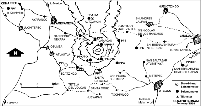 |
Figure 16. Popocatépetl seismic and tilt stations, February 1997. Courtesy of Roberto Quaas, CENAPRED-UNAM. |
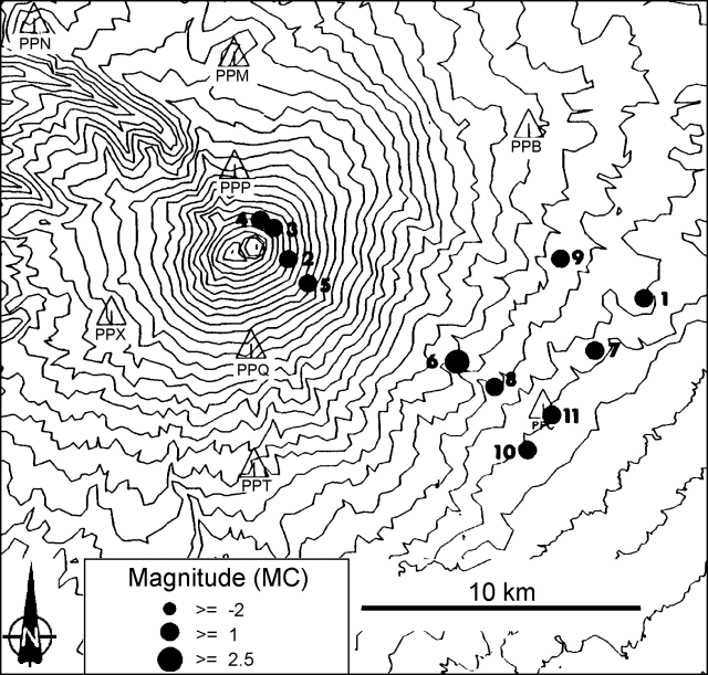 |
Figure 17. Epicenters for Popocatépetl earthquakes registered on the monitoring network, 7-13 April 1997. The contour interval is 100 meters. Courtesy of Roberto Quaas, CENAPRED-UNAM. |
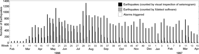 |
Figure 18. Number of weekly Popocatépetl earthquakes counted by visual inspection and using Xdetect software, 5 February-15 April 1997. The number of times alarms were triggered is also shown. Courtesy of Roberto Quaas, CENAPRED-UNAM. |
Figure 18 shows monthly totals both for earthquakes counted by eye directly from the seismograms (higher bars) and by using software called Xdetect (lower bars). Although this latter technique detects events automatically, the totals (which depend on the trigger thresholds) are much smaller than counts made by eye.
Geological Summary. Volcán Popocatépetl, whose name is the Aztec word for smoking mountain, rises 70 km SE of Mexico City to form North America's 2nd-highest volcano. The glacier-clad stratovolcano contains a steep-walled, 400 x 600 m wide crater. The generally symmetrical volcano is modified by the sharp-peaked Ventorrillo on the NW, a remnant of an earlier volcano. At least three previous major cones were destroyed by gravitational failure during the Pleistocene, producing massive debris-avalanche deposits covering broad areas to the south. The modern volcano was constructed south of the late-Pleistocene to Holocene El Fraile cone. Three major Plinian eruptions, the most recent of which took place about 800 CE, have occurred since the mid-Holocene, accompanied by pyroclastic flows and voluminous lahars that swept basins below the volcano. Frequent historical eruptions, first recorded in Aztec codices, have occurred since Pre-Columbian time.
Information Contacts: Roberto Meli, Roberto Quaas Weppen, Servando De la Cruz- Reyna1, Alejandro Mirano, Bertha López Najera, and Alicia Martinez Bringas, Centro Nacional de Prevencion de Desastres (CENAPRED), Delfin Madrigal 665, Col. Pedregal de Santo Domingo, Coyoacan, 04360, México D.F., Mexico. 1Instituto de Geofisica, 1UNAM, Circuito Cientifico C.U.,04510 México D.F., México; NOAA/NESDIS Satellite Analysis Branch (SAB), Room 401, 5200 Auth Road, Camp Springs, MD 20746, USA.