Report on Copahue (Chile-Argentina) — March 1997
Bulletin of the Global Volcanism Network, vol. 22, no. 3 (March 1997)
Managing Editor: Richard Wunderman.
Copahue (Chile-Argentina) Crater lake lies several meters below drainage notch
Please cite this report as:
Global Volcanism Program, 1997. Report on Copahue (Chile-Argentina) (Wunderman, R., ed.). Bulletin of the Global Volcanism Network, 22:3. Smithsonian Institution. https://doi.org/10.5479/si.GVP.BGVN199703-357090
Copahue
Chile-Argentina
37.856°S, 71.183°W; summit elev. 2953 m
All times are local (unless otherwise noted)
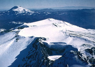
A late-March overflight made after a prolonged dry season enabled scientists to see Copahue with relatively low snow levels. The lake level was some meters below the prominent notch through which drainage occurs on the ESE side of the crater.
Light-gray mud deposits from recent overflow events extended halfway down the E flank. Deposits were also observed to the S and formed a small laharic fan of highly altered material near the head of the Río Lomín.
A pH of 2 was measured in Río Lomín in 1995; in contrast, during March the pH was neutral in the headwaters draining off the lahar fan. However, farther downstream the Río Lomím captures the Estero Turbío, which drains the S flank of the volcano and ran orange, presumably due to high acidity. After capturing Estero Turbío, Río Lomín reportedly became acidic and remained so all the way to its confluence with the Río Biobío, ~33 km from the volcano.
Geological Summary. Volcán Copahue is an elongated composite cone constructed along the Chile-Argentina border within the 6.5 x 8.5 km wide Trapa-Trapa caldera that formed between 0.6 and 0.4 million years ago near the NW margin of the 20 x 15 km Pliocene Caviahue (Del Agrio) caldera. The eastern summit crater, part of a 2-km-long, ENE-WSW line of nine craters, contains a briny, acidic 300-m-wide crater lake (also referred to as El Agrio or Del Agrio) and displays intense fumarolic activity. Acidic hot springs occur below the eastern outlet of the crater lake, contributing to the acidity of the Río Agrio, and another geothermal zone is located within Caviahue caldera about 7 km NE of the summit. Infrequent mild-to-moderate explosive eruptions have been recorded since the 18th century. Twentieth-century eruptions from the crater lake have ejected pyroclastic rocks and chilled liquid sulfur fragments.
Information Contacts: Jose Antonio Naranjo, Servicio Nacional de Geología e Minería (SERNAGEOMIN), Av. Santa María 0104, Casilla 10465, Santiago, Chile; Hugo Moreno Roa, Observatorío Volcanogía de los Andes del Sur (OVDAS), Manantial 1710-Carmino del Alba, Temuco, Chile; Simon R. Young, British Geological Survey (BGS), Murchison House, West Mains Road, Edinburgh EH9 3LA, United Kingdom.

