Report on Monowai (New Zealand) — May 1997
Bulletin of the Global Volcanism Network, vol. 22, no. 5 (May 1997)
Managing Editor: Richard Wunderman.
Monowai (New Zealand) Seismically inferred eruption during 17-20 April
Please cite this report as:
Global Volcanism Program, 1997. Report on Monowai (New Zealand) (Wunderman, R., ed.). Bulletin of the Global Volcanism Network, 22:5. Smithsonian Institution. https://doi.org/10.5479/si.GVP.BGVN199705-242050
Monowai
New Zealand
25.887°S, 177.188°W; summit elev. -132 m
All times are local (unless otherwise noted)
Between 17 and 20 April the seismic network of the French Laboratoire de Geophysique in Tahiti recorded an acoustic swarm from Monowai seamount (figure 3). The swarm ended on 20 April at 2058 GMT. It was very similar to the swarm of September 1996, with similar amplitudes and overall duration.
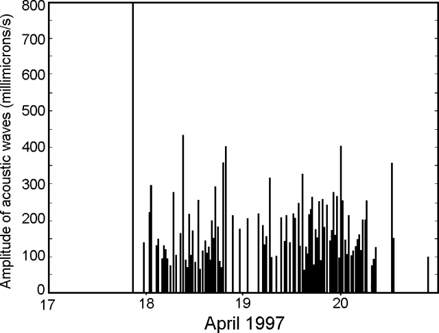 |
Figure 3. The 17-20 April 1997 acoustic swarm at Monawai seamount shown as a plot of wave amplitude versus time. Courtesy of Olivier Hyvernaud. |
The signals for the 17 April acoustic swarm that started at 2007 GMT consisted of strong acoustic waves with a maximum peak-to-peak amplitude of 1.01 m/s. These and later signals were interpreted as an indication of explosive phenomena. The subsequent acoustic waves were weaker, with amplitudes between 50 and 450 millimicrons/second. Overall, the laboratory recorded 136 acoustic waves. Most of the signals clustered into two episodes. The first took place on 18 April during 0013-1911 GMT and included 46 acoustic waves. The second occurred on 19 April during 0308-0810 GMT and included 81 acoustic waves. In addition to including more waves in a shorter time interval, the second episode was stronger.
The above-cited coordinates (25.89°S, 177.19°W) are for the summit of the volcano. A bubbling area was discovered on 17 October 1977 at 25.917°S, 177.233°W. The exact coordinates of the acoustic source discussed here are not well known, and can not be located precisely using currently available T-wave selections.
Proceeding NNE from the Rumble (I, II, III, and IV) seamounts (New Zealand), the next known active volcanoes lie in the Southern Kermadec Islands. From S to N, these consist of Curtis (submarine), Brimstone Island (submarine), Macauley Island (a sub-aerial caldera), Raoul Island (a vigorously active stratovolcano), an unnamed center (submarine), and then Monowai (submarine). Monowai was the source of over six inferred eruptions; in some cases these eruption reports were also based on collateral visual observations such as discolored water and bubbles.
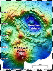
Geological Summary. Monowai, also known as Orion seamount, is a basaltic stratovolcano that rises from a depth of about 1,500 to within 100 m of the ocean surface about halfway between the Kermadec and Tonga island groups, at the southern end of the Tonga Ridge. Small cones occur on the N and W flanks, and an 8.5 x 11 km submarine caldera with a depth of more than 1,500 m lies to the NNE. Numerous eruptions have been identified using submarine acoustic signals since it was first recognized as a volcano in 1977. A shoal that had been reported in 1944 may have been a pumice raft or water disturbance due to degassing. Surface observations have included water discoloration, vigorous gas bubbling, and areas of upwelling water, sometimes accompanied by rumbling noises. It was named for one of the New Zealand Navy bathymetric survey ships that documented its morphology.
Information Contacts: Olivier Hyvernaud, BP 640, Laboratoire de Geophysique, Tahiti, French Polynesia.