Report on San Cristobal (Nicaragua) — May 1997

Bulletin of the Global Volcanism Network, vol. 22, no. 5 (May 1997)
Managing Editor: Richard Wunderman.
San Cristobal (Nicaragua) Eruptions cause ashfall on the slopes; plumes to 2,500 m
Please cite this report as:
Global Volcanism Program, 1997. Report on San Cristobal (Nicaragua) (Wunderman, R., ed.). Bulletin of the Global Volcanism Network, 22:5. Smithsonian Institution. https://doi.org/10.5479/si.GVP.BGVN199705-344020
San Cristobal
Nicaragua
12.702°N, 87.004°W; summit elev. 1745 m
All times are local (unless otherwise noted)
According to press reports quoting an official from the Instituto Nicaraguense de Estudios Territoriales (INETER), an eruptive phase began at San Cristóbal during the night of 19-20 May. Because of the possibility of ashfall, authorities declared a state of alert in the city of Chinandega, one of the largest cities in Nicaragua, situated 20 km WSW, the main downwind direction. A report about precursory seismicity was provided by INETER on 18 May. Observations after the start of eruptive activity were sent by Benjamin van Wyk de Vries (Open University), and include information from INETER scientists.
Precursory activity as of 18 May. Strong seismic activity was detected starting in May, by far the strongest seismicity observed since the new seismic station (CRIN, ~3 km NW of the crater at the base of the volcano), was installed at the end of 1992. As of 18 May CRIN was recording 500 volcano-seismic events/day, with frequencies of 1-6 Hz and durations of ~1 minute or more. Sometimes roughly mono-frequency wavetrains of ~3 Hz were observed. RSAM values climbed from2 odor. INETER volcanologists visited the volcano on 17 May, but could not climb to the crater because of high gas concentrations.
On 18 May INETER was preparing an observation point at Casita volcano, ~4 km SE of San Cristóbal. At the seismic station, CRIN, additional channels with low amplification were switched to be transmitted to the Managua data center. The installation of additional seismic stations is planned. INETER volcanologists took gas and water samples for analysis, and local residents were being interviewed to obtain information about recent changes at the volcano. INETER informed the Nicaraguan Government and the Civil Defense Organization about the situation.
Activity during 21-26 May. B. van Wyk de Vries visited the volcano during 21-23 May, setting up the base for a deformation network, and checking the general state of the cone and crater. RSAM levels stayed fairly constant during this period, but began a slow decline at the end of May. Eruptions through 26 May produced light gray clouds of ash that normally rose 50-200 m above the crater. There were a few notable large eruptions, including one at about 0245 on 22 May that reached 800 m. The height differences were partly due to how quickly the plume was pulled over by the wind. One pulse made a noise that was heard 3 km away at the Casita observation post. Pedro Perez (contracted to The Open University), who was at the crater edge on the morning of the 22nd, noted dull noises before each ejection of ash. Sounds were not heard the next day, when the ejections were less powerful. There were periods of up to a few hours with very weak gas release, then equally long periods of eruptions every 5-10 minutes, or a constant plume. If the wind was strong the plume was dragged down the cone to ~900 m, after which it rose to 1,000-1,200 m; during calmer periods the plume rose to 2,500 m.
Summit visit on 23 May. There was no activity when the crater was reached at 1200 on 23 May. Volcanologists stayed for an hour installing a GPS station on the edge of the outer crater. They made a very quick descent into the crater and saw a new vent. Before the start of activity in early May, San Cristóbal was generally the same as when van Wyk de Vries first saw it in 1986. The main change has been the slow progressive growth of the inner pit crater (figure 2). There is an old outer crater ledge on the S side, then the main crater (10-50 m deep); a small inner cone has been gradually hollowed out by a pit crater. The cone has now mostly fallen in, and only a small part to the S and W still exists. The pit is ~80 m deep and Pedro Perez reported that in early May it had a flat bottom. At that time there was little degassing: a few fumaroles on the SW side and a few fumarole mounds on the SE part of the main crater floor. There had been a vigorous fumarole on the edge of the pit crater, with a temperature of ~600°C, but this part had fallen in. On 23 May there was a 4-m-wide vent in the SW part of the pit crater floor; looking in at 45° no bottom could be seen, and in shadow it was not glowing. On the walls of the pit were dark patches of wet rock, where water seepage or fumarolic emanations had discolored the new ash. The whole of the crater was covered by ash. On the crater floor it was 10 cm deep and around the edges 1-2 cm. The upwind crater rim (SE-N) had a slight dusting. On the downwind rim ash had been stripped off the top of rocks but was accumulating in fine layers on the vertical upwind surfaces. The ash was being continually blown around and formed some beautiful ripples.
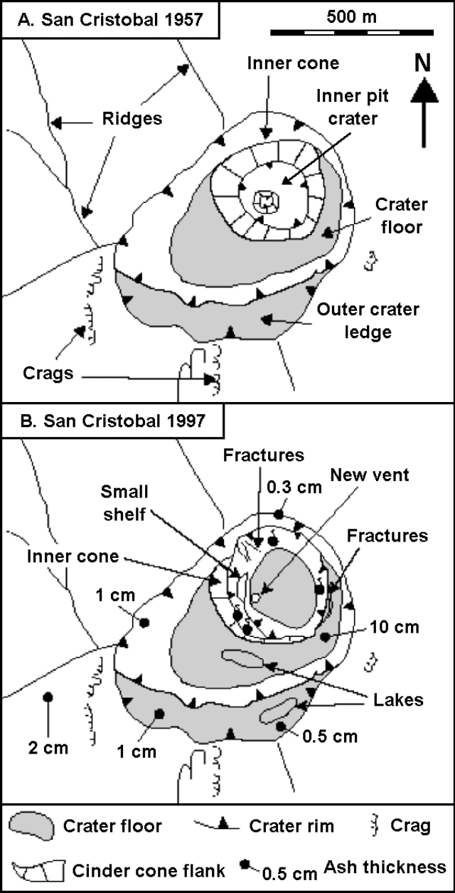 |
Figure 2. Summit maps showing crater features at San Cristóbal in 1957 and May 1997. The 1957 map is based on an aerial photo from the INETER collections. Courtesy of B. van Wyk de Vries, The Open University. |
Ash covered the W side of the mountain, giving it a light-gray appearance down to ~800 m. Although vegetation hid the ash layer from distant viewers, it continued down to ~600 m where a 1-3 mm thick layer coated the ground and dusted the leaves. Gas masks were worn during the descent from the summit because the ash billowed up. Down at the farm of Las Rojas (500 m elevation) there was a slight dusting of ash; other farms reported heavier falls. Vegetation damage was not observed, possibly because everything is so dry in the area. Very light ashfall was occurring 10-15 km downwind.
No tremor was felt at the crater, though there were ~600 events/day being recorded. Campesinos living on the pass between San Cristóbal and Casita felt shocks on the night of 21-22 May. The only significant deformation features noted on 23 May were several fissures around the edge of the inner pit crater, which indicate that it is still enlarging. The fractures on the main crater floor were covered in ash, which was not fractured, indicating that there was no movement over the previous few days. Pedro Perez noted some rockfalls during explosive activity on the morning of the 22nd, from the N side of the pit crater.
Deformation network.The new GPS network consists of two triangles. The outer triangle is centered on a point on the pass between Casita and San Cristóbal, with one position on Casita, one 2 km SE of Chinandega, and one 10 km NE of Chinandega. The lines are ~10 km long. The center point should form one corner of an inner triangle, the other points being at Las Rojas farm to the W and one as yet undecided on the N flank. These lines are <5 km long. Within the inner triangle, points were placed at ~1,500 m elevation on the SE flank and on the W side of the crater edge at ~1,700 m; both are 1-2 km from the center point. Simultaneous measurements at all four of the outer triangle points were taken with the Open University GPS and the INETER GPS. Two points on the volcano were fixed, and will be re-occupied by INETER personnel. Although the whole of the network is not in place, at least three points on the volcano have been fixed and will indicate any major movement.
Volcanic history. San Cristóbal is a stratovolcano 100 km NW of Managua that has erupted about nine times since the Spanish conquest. Its previous most recent confirmed eruption was a 45-minute ash emission in October 1977 (SEAN 02:10), but a small ash emission may have occurred in November 1987 (SEAN 13:01). The San Cristóbal complex comprises San Cristóbal cone, El Chonco cone, Cerro Montoso, Casita volcano, and La Pelona Caldera (Hazlet, 1987; Van Wyk de Vries and Borgia, 1996). San Cristóbal proper is the youngest feature of the complex. Casita was probably active in the 16th century, and has several active fumarole fields. La Pelona looks as though it was once a large stratocone that underwent a caldera-forming eruption in the Quaternary. El Chonco is an 800-m-high andesite-dacite cone. Cerro Montoso is a 600-m-high andesitic scoria cone cut by large faults.
The complex as a whole has a tendency to produce significant amounts of dacitic magma. Examples include the Chonco cone and Loma La Teta (a dacite dome associated with El Chonco), recent pyroclastic-flow and tephra deposits on San Cristóbal and Casita, and the La Pelona Caldera ignimbrite. This type of magma contrasts with the predominant basalt-basaltic andesite of the other nearby volcanoes, such as Telica, Rota, and El Hoyo/Cerro Negro. Martha Navarro (INETER), who has done geological and hazard mapping at San Cristóbal, noted that the dacitic pyroclastic-flow deposits of San Cristóbal are similar in composition to a thick tephra-fall deposit that the forms subsoil over much of the west side of the cone. On the cone itself, these deposits are covered by more recent andesitic scoriae and bombs, some or all of which come from the historical eruptions in the 17th century and the 1970's. There have not been any historical lava flows, but several lava flows are still only partially vegetated.
References. Hazlett, R.W., 1987, Geology of the San Cristóbal volcanic complex, Nicaragua, in Williams, S.N. and Carr, M.J. (eds.), Richard E. Stoiber 75th Birthday Volume: J. Volcanol. Geotherm. Res., v. 33, p. 223-230.
Van Wyk de Vries, B., and Borgia, A., 1996, The role of basement in volcano deformation, in McGuire, W.J., Jones, A.P., and Neuberg, J. (eds.), Volcano Instability on the Earth and Other Planets: Geological Society Special Publication 110, London, p. 95-110.
Geological Summary. The San Cristóbal volcanic complex, consisting of five principal volcanic edifices, forms the NW end of the Marrabios Range. The symmetrical 1745-m-high youngest cone, named San Cristóbal (also known as El Viejo), is Nicaragua's highest volcano and is capped by a 500 x 600 m wide crater. El Chonco, with several flank lava domes, is located 4 km W of San Cristóbal; it and the eroded Moyotepe volcano, 4 km NE of San Cristóbal, are of Pleistocene age. Volcán Casita, containing an elongated summit crater, lies immediately east of San Cristóbal and was the site of a catastrophic landslide and lahar in 1998. The Plio-Pleistocene La Pelona caldera is located at the eastern end of the complex. Historical eruptions from San Cristóbal, consisting of small-to-moderate explosive activity, have been reported since the 16th century. Some other 16th-century eruptions attributed to Casita volcano are uncertain and may pertain to other Marrabios Range volcanoes.
Information Contacts: Wilfried Strauch and Pedro Perez, Department of Geophysics, Instituto Nicaraguense de Estudios Territoriales (INETER), P.O. Box 1761, Managua, Nicaragua; Benjamin van Wyk de Vries, Department of Earth Sciences, The Open University, Milton Keynes MK7 6AA, United Kingdom; Reuters.