Report on Popocatepetl (Mexico) — July 1997

Bulletin of the Global Volcanism Network, vol. 22, no. 7 (July 1997)
Managing Editor: Richard Wunderman.
Popocatepetl (Mexico) Largest ash emission of the 1994-97 eruption on 30 June
Please cite this report as:
Global Volcanism Program, 1997. Report on Popocatepetl (Mexico) (Wunderman, R., ed.). Bulletin of the Global Volcanism Network, 22:7. Smithsonian Institution. https://doi.org/10.5479/si.GVP.BGVN199707-341090
Popocatepetl
Mexico
19.023°N, 98.622°W; summit elev. 5393 m
All times are local (unless otherwise noted)
The following includes summaries of reports from a) the Institute of Geophysics at the University of México (UNAM), b) the Centro Nacional de Prevencion de Disastres (CENAPRED), c) the NOAA Satellite Analysis Branch (SAB), and d) the United Nations Department of Human Affairs (DHA). This report covers the period from 2 May to 25 August. The most forceful emission in the 1994-97 episode took place on 30 June; ashfall shut down the Mexico City airport stranding passengers and spurring numerous press reports.
A series of non-technical reports during 2 May to 25 June (table 6) described isolated explosions and occasional A-type seismic events in a pattern that has characterized Popocatépetl's behavior since September 1996. A cross section shows the location of the volcano-tectonic earthquakes that occurred during 29 April-29 July; a table lists their locations during August.
Table 6. Summary of non-technical reports describing activity at Popocatépetl, 2 May-25 June 1997. The alert status remained moderate (yellow) during this interval. Courtesy of Roberto Quaas, CENAPRED-UNAM.
| Report Date | Comment |
| 02 May 1997 | The level of activity remained low, with sporadic low-intensity emissions and white plume. |
| 05 May 1997 | At 0839 there was a moderate emission of ash that generated a column ~2 km high drifting to the W. Ashfall was reported in the towns of Tepetlixa and Ozumba. |
| 07 May 1997 | On 6 May a major ash emission occurred at 2039 and lasted 20 minutes. The cloud drifted toward E and NE causing ash and coarser tephra to fall in Cholula and some areas in Puebla and Veracruz. |
| 14 May 1997 | On 13 May at 2230 a moderate emission included incandescent fragments that fell near the crater. Ashfall started afterwards on the towns of San Pedro Benito Juarez, San Nicholas de los Ranchos, Calpan, and Santiago Xlizintla, where weak earthquakes were also felt. |
| 24 May 1997 | After several days of relative quiet a high frequency tremor was recorded at 0927. In the meantime ash was emitted up to 200 m above the crater. The plume drifted to the ENE causing minor ashfall in the towns of Calpan, Xalitzintla, San Nicolas de los Ranchos and Nealtican. |
| 11 Jun 1997 | At 1014 a 15-minute-long tremor accompanied a major ash emission that reached an altitude of 4 km (see figure 19). The column blew towards the WSW. |
| 18 Jun 1997 | Activity was again at low levels. When inspected by helicopter, the summit glacier appeared normal. |
| 25 Jun 1997 | The activity was at stable, low levels, with minor emissions and an almost constant presence of a low steam plume on the summit. |
Activity during 2 May to 25 August 1997. Large ash emissions occurred on 11, 14, 15, 24, and 27 May and noteworthy or large emissions occurred on 3, 11, 14, 19, 21, and 30 June. On 28 May satellite imagery showed an ash cloud moving rapidly SE as it approached the Yucatan peninsula.
On 11 June ash streamed S of the volcano at 28 km/h. The cloud measured 50 km long and 33 km across (figure 19). The following day ash was reported at an altitude of 6-8 km; thicker ash closer to the volcano moved S at ~50 km/hour while an area of very diffuse ash headed SW. The 14 June eruption was visible from both Mexico City and Puebla; satellite imagery showed the plume heading WSW at ~40 km/hour. The plume later separated: a thicker L-shaped area fanned NW to W at 30 km/h at an altitude of ~10 km, and a faint area of thinning ash moved W at ~64 km/hour ahead of a thick-ash area at 7-km altitude. Reports of sand-sized ashfall came from Nepantla, Amecameca, and other towns as far as Cuautla. On the Puebla side of the volcano several towns reported mudflows associated with heavy rains and minor melting.
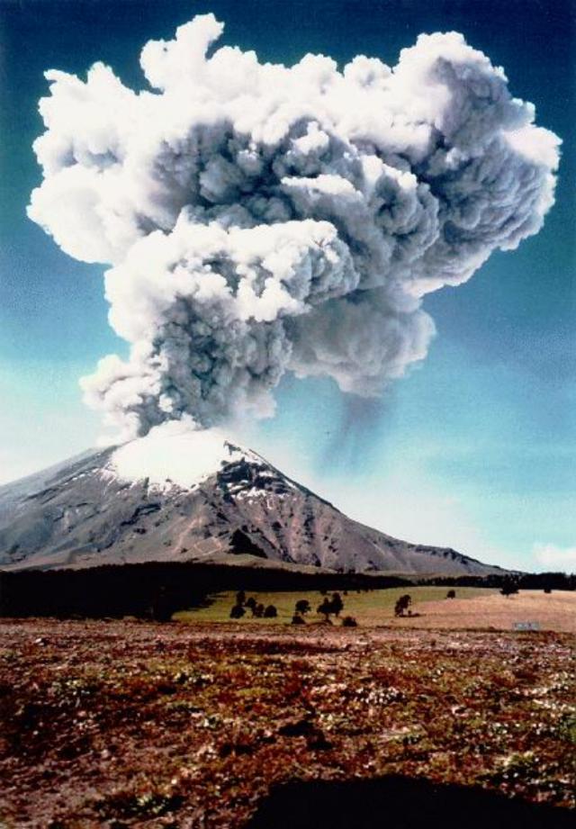 |
Figure 19. Popocatépetl ash column; photo taken from the NW (above Paso de Cortes) at 1032 on 11 June 1997. See table 6 for a brief description of the ash emission. Courtesy of CENAPRED. |
On 12 June Tom Casadevall noted that he had learned from an engine manufacturer that ". . . all three major Mexican airlines (Mexicana, Aeromexico, and TAESA) have reported windshield damage that they attribute to volcanic ash. Also, Aeromexico reported heavier than normal blade erosion on one MD80 engine that it attributes to ingestion of volcanic ash from Popocatépetl. Apparently the local atmosphere now contains an above average concentration of ash."
The 30 June ash emission was the largest recorded since the current eruptive episode initiated in 1994. Beginning at 1656 on 30 June there were seven volcano-tectonic earthquakes (M 2-2.7) in a 13-minute interval. At 1711 a large tremor signal marked the eruption's start. The first pulse lasted 135 minutes. The second one, beginning at 1926, lasted about 90 minutes. The latter eruption sent an ash plume 13 km above sea level within minutes. About 2-3 hours later, ash started falling over many towns around the volcano, including Mexico City.
In spite of the outbursts during this eruptive episode, estimated to a VEI of 2-3, no casualties or damage were reported; the volcanic alert code was raised to red but no evacuation was involved. The airport in Mexico City was closed for about 12 hours, until the ash was washed away from the runways. Pumice fragments as large as 10 cm fell sparsely on the N flank at Paso de Cortes and over a few kilometers along the road to Amecameca.
According to the real-time seismic amplitude measurement recordings (RSAM), the 30 June event alone released an estimated energy equivalent to one-tenth of the seismic energy release during an average year. The highest intensity phase lasted about 35 minutes and then declined.
During the two days following the eruption, some minor mudflows were reported at the town of Santiago Xalitzintla, about 12 km NE of the volcano. The flows coincided with heavy rain inundating a small area in the bottom of a ravine where a small house partially flooded. Inspection of the house, local fruit trees, and a small corn field in the area, showed that the flow was rather slow. After the major ash emission on 30 June, the volcano quieted. Steam emissions continued, at times accompanied by ash; these emissions were small except for a relatively large event on 2 July.
Helicopter observations on 3 and 4 July disclosed new features. There were several 1- to 2-km-long tongues radiating down the volcano's S and SE flanks. These tongues were interpreted as granular flows produced by partial collapse of the eruptive column. Inside the main crater on the 1996 lava dome there was a new crater enclosing a fresh ropy-lava body. As a preliminary interpretation, it seemed that in the first stages of the 30 June event the previous dome was partially destroyed by explosions, forming the initial crater. Then the crater was flooded with fresh magma that apparently underwent significant fragmentation, generating the moderately large ash emission and leaving a new lava body with a conical depression. In response to these events, a UNDP/DHA Resident Representative reported on 4 July that preparedness measures were undertaken. CENAPRED provided ongoing information to the villages on the outskirts of the volcano (total population, 102,000).
On 30 July, Mexico City's international airport reported continuous ash emissions to 8-km altitude. Satellite observations then were hampered by broken clouds.
After 30 July, activity decreased until 12 August, when a moderately large emission discharged ash 5 km above the crater. By another account the ash only rose 2 km. This emission lasted for more than two hours and produced SW-flank ashfall. After this event the color of the volcanic alert light remained yellow. During the afternoon another 3-minute emission sent an ash plume to 2.5 km above the summit.
Activity remained low until 25 August but included frequent low- to moderate-intensity gas-and-steam emissions, some with small amounts of ash. Around this time, the highest number of emissions per day was 41 on 21 August.
Low-frequency tremors of variable duration (between 2 and 40 minutes) occurred sporadically during this period. Figure 20 shows the hypocenters of the volcano-tectonic earthquakes located during March-July; table 7 lists those during August.
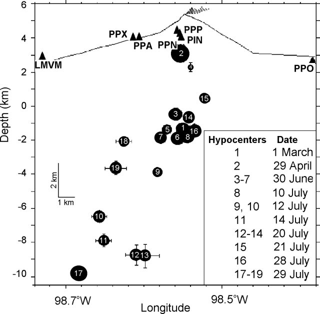 |
Figure 20. Cross section of Popocatépetl made from a perspective of looking towards the N; it shows the hypocenters of the volcano-tectonic earthquakes located during March-July 1997. The numbers key to the day of occurrence (see box), the dot sizes are proportional to the magnitude (no scale given). Vertical exaggeration is 2:1. Courtesy of CENAPRED. |
Table 7. Occurrence of local volcano-tectonic earthquakes at Popocatépetl during August 1997. Courtesy of CENAPRED.
| Date | Magnitude | Location |
| 13 Aug 1997 | 2.3 | 4.4 km under SE flank |
| 14 Aug 1997 | 2.2 | 6.8 km under the summit |
| 14 Aug 1997 | 2.5 | 5.3 km under the summit to the SE |
| 17 Aug 1997 | 2.4 | SE region |
| 19 Aug 1997 | 2.1 | 7.3 km under the summit to the NE |
| 19 Aug 1997 | 1.7 | 4.6 km under the summit to the E |
| 20 Aug 1997 | 2.6 | 5.8 km under the summit |
| 20 Aug 1997 | 2.2 | 5 km under the summit |
| 20 Aug 1997 | 2.3 | 5.7 km under the summit |
Geological Summary. Volcán Popocatépetl, whose name is the Aztec word for smoking mountain, rises 70 km SE of Mexico City to form North America's 2nd-highest volcano. The glacier-clad stratovolcano contains a steep-walled, 400 x 600 m wide crater. The generally symmetrical volcano is modified by the sharp-peaked Ventorrillo on the NW, a remnant of an earlier volcano. At least three previous major cones were destroyed by gravitational failure during the Pleistocene, producing massive debris-avalanche deposits covering broad areas to the south. The modern volcano was constructed south of the late-Pleistocene to Holocene El Fraile cone. Three major Plinian eruptions, the most recent of which took place about 800 CE, have occurred since the mid-Holocene, accompanied by pyroclastic flows and voluminous lahars that swept basins below the volcano. Frequent historical eruptions, first recorded in Aztec codices, have occurred since Pre-Columbian time.
Information Contacts: Roberto Meli, Roberto Quaas Weppen, Alejandro Mirano, Bertha López Najera, Alicia Martinez Bringas, A. Montalvo, G. Fregoso, and F. Galicia, Centro Nacional de Prevencion de Desastres (CENAPRED), Delfin Madrigal 665, Col. Pedregal de Santo Domingo, Coyoacan, 04360 México D.F., México (URL: https://www.gob.mx/cenapred/); J.L. Macias, Instituto de Geofisica, UNAM, Circuito Cientifico C.U. 04510 México D.F., México; NOAA/NESDIS Satellite Analysis Branch (SAB), Room 401, 5200 Auth Road, Camp Springs, MD 20746, USA; Thomas J. Casadevall, Office of the Regional Director, U.S. Geological Survey, MS 150, 345 Middlefield Rd., Menlo Park, CA 94025 USA; M. Moulin-Acevedo UNDP/DHA, United Nations, Palais des Nations, 1211 Geneva 10, Switzerland.