Report on Sabancaya (Peru) — July 1997

Bulletin of the Global Volcanism Network, vol. 22, no. 7 (July 1997)
Managing Editor: Richard Wunderman.
Sabancaya (Peru) Quiet on 19 July; ash-bearing plumes on 1-2 May
Please cite this report as:
Global Volcanism Program, 1997. Report on Sabancaya (Peru) (Wunderman, R., ed.). Bulletin of the Global Volcanism Network, 22:7. Smithsonian Institution. https://doi.org/10.5479/si.GVP.BGVN199707-354006
Sabancaya
Peru
15.787°S, 71.857°W; summit elev. 5960 m
All times are local (unless otherwise noted)
During a mid-[July] visit, Sabancaya displayed only fumarolic activity. Visiting scientists also examined the area well to Sabancaya's N along the Colca river. They determined that previous reports of destructive, seismically triggered mudslides in 1991 (BGVN 16:07) had been incorrect.
On 19 July scientists flew over Sabancaya and the two adjacent volcanoes Ampato and Hualca Hualca (figure 5) while taking slides and Super VHS images. Ice fields and snow cover were observed only on the summit regions of Ampato (6,288 m) and Hualca Hualca (6,025 m). Thus, the ice fields that existed on Sabancaya prior to the most recent eruption (29 May 1991, BGVN 15:05) had not returned.
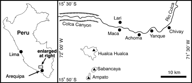 |
Figure 5. Map of the region around Sabancaya showing adjacent stratovolcanoes and the Colca river. This segment of the Colca river flows westwards. Courtesy of M. Bulmer, F. Engle, and A. Johnston, CEPS. |
As the photo (figure 6) reveals, Sabancaya's cone remains nearly symmetrical with slopes of 30-40 degrees. The cone is roughly 1 km in diameter and contains a central crater with a diameter of approximately 400 m. Slope failure occurred along a ~600-m-long arcuate scarp seen on the cone's NE flank. This could prove to be a zone of weakness in any future eruption. An active fumarole was located at the summit cone in a spot on the wall of the southern crater rim; it vented rapidly. Less active fumaroles were seen on the western crater wall and sulfur deposits occurred on the upper crater walls. When the cone was viewed from a distance of 1 km, observers saw significant atmospheric aberrations that implied gas emissions.
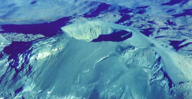 |
Figure 6. Aerial photo of Sabancaya taken on 19 July 1997 looking W. The crater is approximately 400 m in diameter. The surface of the cone is mantled in young ash deposits (not snow). Courtesy of M. Bulmer, F. Engle, and A. Johnston, CEPS. |
In the Colca Valley scientists saw extensive damage from the 23-24 July 1991 earthquake swarm including abandoned, damaged buildings, and slope failures; what they failed to find, however, was evidence that mudslides had ravaged local villages. This was important because BGVN 16:07 briefly described seismic damage from the earthquakes but also stated that they ". . . triggered mudslides that partly buried four villages." Based on this latest visit, this latter statement was clearly incorrect; it may have stemmed from the cited press accounts.
The scientists visited the villages of Maca, Achoma, Yanque, Lari, and Chivay. The earthquake damage was greatest in Maca, which lies in the Colca valley below the NNE flank of Hualca Hualca, a spot 15 km N of Sabancaya. Particularly in Maca, there was abundant evidence of seismically induced damage to structures. It should be noted that most buildings in the region had been constructed with walls made of loose stone without the benefit of concrete mortar or steel reinforcing.
On the NW side of Maca the group found evidence for a series of rotational and translational slides and slumps triggered by 2 m of throw along a normal fault. There was a series of well defined backscarps delineating different slope failures (figure 7) that extended ~1 km from the NW margin of Maca down to the Colca river. No houses were located on the failed surfaces; instead, this area had been terraced for agricultural use, but it was fallow when visited. The failure "complex" remained mobile and its toe was being undercut by the river. The village of Maca was being rebuilt gradually as people returned to the area. Some of the new housing includes concrete structures but most are made of adobe (clay and straw) brick with corrugated sheet-metal roofing.
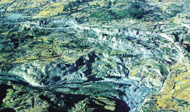 |
Figure 7. Aerial photo of Sabancaya taken on 19 June 1997 looking SE; it shows slope failures located NW of the village of Maca. The Rio Colca is visible in the lower part of the image. Note the road running across the upper third of the photo (trending E-W); it had to be realigned near Maca. Maca's market square can be seen in the upper left side of photo. Courtesy of M. Bulmer, F. Engle, and A. Johnston, CEPS. |
Prior to the visit, on 1 and 2 May, aviation reports described ash-bearing plumes. The plume on 1 May reportedly reached ~5.5-km altitude; the one on 2 May, ~7.3-km altitude.
Geological Summary. Sabancaya, located in the saddle NE of Ampato and SE of Hualca Hualca volcanoes, is the youngest of these volcanic centers and the only one to have erupted in historical time. The oldest of the three, Nevado Hualca Hualca, is of probable late-Pliocene to early Pleistocene age. The name Sabancaya (meaning "tongue of fire" in the Quechua language) first appeared in records in 1595 CE, suggesting activity prior to that date. Holocene activity has consisted of Plinian eruptions followed by emission of voluminous andesitic and dacitic lava flows, which form an extensive apron around the volcano on all sides but the south. Records of observed eruptions date back to 1750 CE.
Information Contacts: M.H. Bulmer, F. Engle, and A. Johnston, Center for Earth and Planetary Studies (CEPS), National Air and Space Museum, Smithsonian Institution, Washington, DC 20560 USA; Guido Salas, Universidad de San Agustin, Casilla 1203, Arequipa, Perú; A. Seimon, Department of Geography, University of Colorado, Boulder, CO 80309-0260 USA; NOAA/NESDIS Satellite Analysis Branch (SAB), Room 401, 5200 Auth Road, Camp Springs, MD 20746, USA; Tom Fox, Air Navigation Bureau, International Civil Aviation Organization (ICAO), 999 University St., Montreal H3C 5H7, Canada (URL: https://www.icao.int/safety/airnavigation/).