Report on Soufriere Hills (United Kingdom) — September 1997

Bulletin of the Global Volcanism Network, vol. 22, no. 9 (September 1997)
Managing Editor: Richard Wunderman.
Soufriere Hills (United Kingdom) Repeated pyroclastic flows during 31 August-13 September
Please cite this report as:
Global Volcanism Program, 1997. Report on Soufriere Hills (United Kingdom) (Wunderman, R., ed.). Bulletin of the Global Volcanism Network, 22:9. Smithsonian Institution. https://doi.org/10.5479/si.GVP.BGVN199709-360050
Soufriere Hills
United Kingdom
16.72°N, 62.18°W; summit elev. 915 m
All times are local (unless otherwise noted)
The following condenses both Daily Reports and Scientific Report 73 of the Montserrat Volcano Observatory (MVO) for the interval 31 August-13 September 1997. Throughout this two-week period repeated pyroclastic flows left the upper part of Mosquito Ghaut (the drainage directly N of Chances Peak) completely filled. Electronic surveys (EDM) indicated sites in the volcano's NW quadrant (Lee's Yard quadrangle) moved very slowly. Very preliminary analysis of the dome and pyroclastic flow deposits suggested that around early September the extrusion rate was ~6-7 m3/s. Although provisional, this was the highest sustained extrusion rate since the eruption began.
Revisions to the previous hazard map (BGVN 22:06) yielded a new map on the MVO website in September (figure 31). The new map contains two boundaries that had shifted northward compared to the previous one; these boundaries identify three hazard zones described in the figure caption. Chances Peak, the old summit, lies on the W-central side of the volcano's summit area.
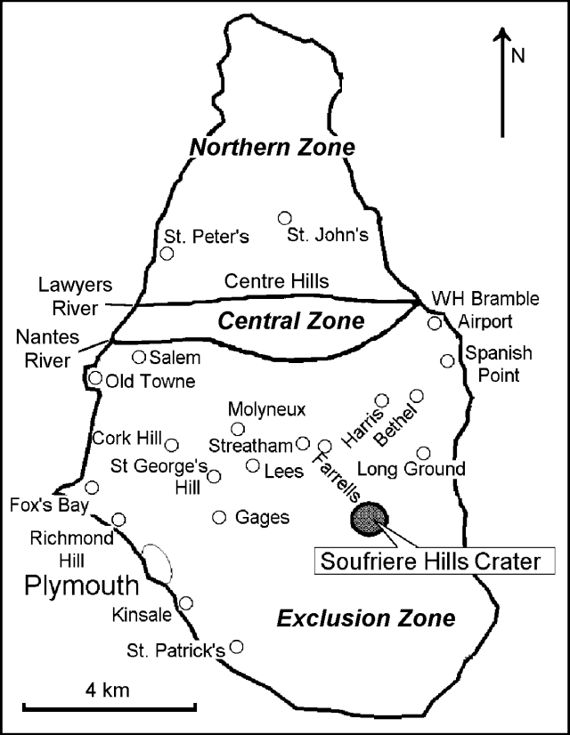 |
Figure 31. September 1997 Montserrat volcano risk map showing three main risk zones. The Exclusion Zone was designated "No admittance except for scientific monitoring and National Security Matters." The Central Zone was designated "Residential area only, all resident[s] on heightened state of alert. All resident[s] to have rapid means of exit 24 hours per day. [In the] hard hat area, all residents to have hard hats and dust masks." The Northern Zone was designated as "Area with significantly lower risk, suitable for residential and commercial occupation." Courtesy of MVO. |
31 August-13 September. On 31 August activity remained high and cyclic patterns were evident in the seismic data. After 31 August, pyroclastic flows decreased and generally remained low until 4 September when the level again increased slightly. On 4 September, several hours of pronounced rockfalls were noted; then, at 1540, two detonation sounds were heard associated with a rapidly rising ash cloud and a pyroclastic flow. In the evening, the volcano's upper flanks were unobscured allowing viewers to see a concentration of activity on the dome's N side above Mosquito Ghaut. As had been the case during the last two days of August, rockfall and pyroclastic flow activity continued to show a ~12-hour cyclicity during these first few days of September. This did not continue after 4 September and activity for the rest of the period showed no clear long-lasting pattern although there were a number of earthquake swarms tabulated in MVO's reports.
On 5 and 6 September volcanic activity was generally relatively low. Views of the dome were very clear during the night of 5 September disclosing semi-continuous rockfalls down Mosquito Ghaut and more restricted activity on the upper W flank. Activity increased for about an hour on the morning of 8 September, when a series of moderate pyroclastic flows descended the N flank. Wholly unconstrained by Mosquito Ghaut, these flows spread W (over Farrell's plain) moving ~2 km NNW of Chances Peak (around Riley's Estate) and then progressing towards the W following the Belham drainage system. These flows all moved relatively slowly but reached ~3 km NW of Chances Peak (Dyer's River immediately south of Molyneux). They left the first substantial block-and-ashflows yet deposited in the Belham Valley during the current crisis. In contrast, the pyroclastic flow in the Belham Valley on 25 June deposited a dense ashflow and explosions during August deposited thin pumice flows.
The report for 7 September noted two episodes with intense pyroclastic flow activity due to collapse of hot dome lava. Both of these episodes lasted about an hour-and-a-half and sent material onto the N flank (Tuitt's Ghaut and Farrell's plain). As measured from Chances Peak the pyroclastic flows progressed to distances ~3 km NNE and ~2.6 km NW (to below Harris Lookout on the E and to the to the upper parts of the Belham Valley as far as Dyer's Bridge on the W). After these pyroclastic flows, Farrell's plain was left covered with big boulders. On 7 September, lofted ash blew in an unusual direction, NE. As a consequence ash fell on the neighboring island of Antigua affecting the V.C. Bird International Airport there.
Heightened activity was again noted on 8-9 September. On the latter day there were two main episodes that produced N-directed pyroclastic flows due to dome collapse: the first episode lasted between 0230 and 0430 and was preceded by a hybrid earthquake swarm, the second episode was more intense and lasted from 1005 until 1407 with several discrete pulses. The second episode peaked at 1300 when a series of vigorously convecting pyroclastic flows were observed from MVO's observatory site in Old Towne (7 km NW of Chances Peak). At least two of the flows deposited material on the volcano's northwestern flanks (into an unnamed ghaut in the headwaters of the Belham drainage system). Seismic signals during the venting of the pyroclastic flows and dome collapses had long- period precursors, signals previously associated with gas venting and explosions.
On 9-10 September MVO moved its observatory to a spot along the island's main axis lying ~8 km N and ~1.25 km W of Chances Peak. This spot is called "Mongo Hill" (labeled as Mango Hill on some maps).
The daily report discussing 9-10 September described two hybrid earthquake swarms, each lasting about 2 hours. The first was clearly associated with increased volcanic activity. On 11 September the volcano remained shrouded in cloud for much of the day.
The daily report for the 24-hour period ending at 1600 on 13 September 1997 noted especially vigorous pyroclastic flow activity. The summit of the volcano was shrouded in cloud for much of the day; however, good visual observations were possible because of ash plumes rising above the clouds and of pyroclastic flows descending the N flank. The most vigorous activity in the middle of the afternoon produced pyroclastic flows funneling NW into the uppermost part of the Belham valley in the Dyer's area and also at least one audible explosion from the dome. Ash clouds rose typically to 1.5 km, being generated both from pyroclastic flows and from continuous summit venting. New pyroclastic flows were also noted on the volcano's NNE and NE-E (in Tuitt's and the Tar River drainages), and provisionally to its SW (in the White River).
Geological Summary. The complex, dominantly andesitic Soufrière Hills volcano occupies the southern half of the island of Montserrat. The summit area consists primarily of a series of lava domes emplaced along an ESE-trending zone. The volcano is flanked by Pleistocene complexes to the north and south. English's Crater, a 1-km-wide crater breached widely to the east by edifice collapse, was formed about 2000 years ago as a result of the youngest of several collapse events producing submarine debris-avalanche deposits. Block-and-ash flow and surge deposits associated with dome growth predominate in flank deposits, including those from an eruption that likely preceded the 1632 CE settlement of the island, allowing cultivation on recently devegetated land to near the summit. Non-eruptive seismic swarms occurred at 30-year intervals in the 20th century, but no historical eruptions were recorded until 1995. Long-term small-to-moderate ash eruptions beginning in that year were later accompanied by lava-dome growth and pyroclastic flows that forced evacuation of the southern half of the island and ultimately destroyed the capital city of Plymouth, causing major social and economic disruption.
Information Contacts: Montserrat Volcano Observatory (MVO), c/o Chief Minister's Office, PO Box 292, Plymouth, Montserrat (URL: http://www.mvo.ms/); NOAA/NESDIS Satellite Analysis Branch (SAB), Room 401, 5200 Auth Road, Camp Spring, MD 20746, USA.