Report on Popocatepetl (Mexico) — October 1997

Bulletin of the Global Volcanism Network, vol. 22, no. 10 (October 1997)
Managing Editor: Richard Wunderman.
Popocatepetl (Mexico) Small and moderate emissions; low-level seismicity
Please cite this report as:
Global Volcanism Program, 1997. Report on Popocatepetl (Mexico) (Wunderman, R., ed.). Bulletin of the Global Volcanism Network, 22:10. Smithsonian Institution. https://doi.org/10.5479/si.GVP.BGVN199710-341090
Popocatepetl
Mexico
19.023°N, 98.622°W; summit elev. 5393 m
All times are local (unless otherwise noted)
Popocatépetl continued to generate small and moderate emissions and low-level seismic activity following the large ash emission of 30 June (BGVN 22:07). The volcanic alert status remained yellow through August, September, and October. The following, taken from CENAPRED daily summaries, outlines the characteristic emissions and seismic activity from mid-August to the end of October. Also during this period, a small lava dome grew in the crater, and scientists installed additional monitoring equipment.
Moderate to large emissions were frequently observed during 12 August-31 October (figure 21). Characteristic low-level venting of gas and steam were an ongoing background activity. The large ash column of 12 August, considered the most significant since 30 June, was succeeded by a week of frequent, small emissions of gas and steam occasionally bearing ash, although poor visibility impaired observation of the summit. On the 18th a column of ash rose 500 m above the summit. Fumarolic plumes persisted during 20-24 August and on the 26th an ash column rose to 1 km. Frequent moderate emissions of gas and steam prevailed from 27 August to 2 September. The climax occurred on 30 August coincident with seven harmonic tremors in an 8-hour period. Observed emissions decreased thereafter, generally remaining stable at diminished levels until the end of September. A persistent gas-and-steam plume was the only activity observed during 20-24 September; observation was hindered by bad weather on the 25th. Starting on 28 September activity began to increase, but again observation was limited by bad weather. In early October small amounts of light ash may have been produced.
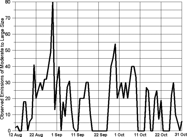 |
Figure 21. Daily number of observed emissions at Popocatépetl, 12 August-31 October 1997. Data courtesy of CENAPRED. |
Beginning on 4 October moderate emissions included light ash; these increased steadily for a week. Steam plumes from a crater fumarole were seen on 8 and 10 October, but no important changes to the summit or glacier were observed. Activity was variable on the 9th as a hurricane passed by on the Pacific coast, obscuring the mountain, and on the 12th a plume rising to 1 km was dispersed NE. Activity declined steadily after the 12th to the end of October, except for a few isolated increases. Gas emissions can be gauged by the measurement on 20 October of 9,000 metric tons/day of SO2. On both the 22nd and 27th short increases in the number of emissions were followed by harmonic tremor. Ash plumes were seen on the 24th and 26th.
Almost daily tremors lasted a few seconds to many minutes. Several A-type earthquakes were distributed through the period (figure 22). The thirty-five events recorded ranged from M 1.75 to 2.70 at depths of 3-8 km, mostly under the summit or in the direction of the SE flank. Several A-type earthquakes, other disturbances, or both occurred on 19 and 20 August, 8, 10, 26, and 28 September, and 24-26 October. On 20 October four A-type events were followed by 15 minutes of harmonic tremor.
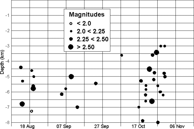 |
Figure 22. Popocatépetl earthquake magnitudes and depths, 12 August-31 October 1997. Data courtesy of CENAPRED. |
Aerial photos of the crater had revealed a small growing lava dome possibly related to harmonic tremor episodes on 17 and 18 August. During a helicopter flight on the morning of 3 September, scientists noted an increase in the lava dome, although it still filled
Slight tilt changes recorded by inclinometers on 14 October possibly indicated a small deflation of the E flank. The next day tilt remained stable or in some cases returned to previous levels, but shifted again on the 16th and continued until the 21st. Tilts again shifted on 24 and 30 October.
As a joint project involving experts from CENAPRED and the Cascades Volcano Observatory, an automatic flow detection system (see table 8) was installed on the N flank of the volcano beginning 9 October. Due to bad weather and high seismicity only the repeater station, which will receive local signals and transmit them to CENAPRED, could be installed. Work continued on 14-15 October when the PFM3 and PFM1 stations were installed; PFM2 was installed on 7 November. Each station consists of a seismic flow detector, a rain gauge, conditioning circuits, and a data transmitter.
Table 8. Recently installed monitoring equipment at Popocatéptl. Courtesy of CENAPRED.
| Station | Location | Sensor | Elev | Latitude | Longitude | Equipment |
| CENAPRED | National Center for Disaster Prevention, Mexico | PCR | 2,365 m | 19.3151 N | 99.1747 W | Central information recording and processing station |
| CANARIO | Canario shelter, Tenenepanco ravine, N slope | PFM1 | 4,170 m | 19.0412 N | 98.628 W | Seismic flow detector and rain gauge |
| ESPINERA | Espinera ravine, N slope | PFM2 | 4,294 m | 19.0383 N | 98.6255 W | Seismic flow detector and rain gauge |
| UNION | Junction of Espinera and Tenenepanco ravines | PFM3 | 3,693 m | 19.0681 N | 98.6122 W | Seismic flow detector and rain gauge |
| TLAMACAS | Microwave site, Tlamacas hill | PFM4 | 3,980 m | 19.0663 N | 98.6278 W | Repeater station |
Geological Summary. Volcán Popocatépetl, whose name is the Aztec word for smoking mountain, rises 70 km SE of Mexico City to form North America's 2nd-highest volcano. The glacier-clad stratovolcano contains a steep-walled, 400 x 600 m wide crater. The generally symmetrical volcano is modified by the sharp-peaked Ventorrillo on the NW, a remnant of an earlier volcano. At least three previous major cones were destroyed by gravitational failure during the Pleistocene, producing massive debris-avalanche deposits covering broad areas to the south. The modern volcano was constructed south of the late-Pleistocene to Holocene El Fraile cone. Three major Plinian eruptions, the most recent of which took place about 800 CE, have occurred since the mid-Holocene, accompanied by pyroclastic flows and voluminous lahars that swept basins below the volcano. Frequent historical eruptions, first recorded in Aztec codices, have occurred since Pre-Columbian time.
Information Contacts: Roberto Quaas Weppen, Centro Nacional de Prevencion de Desastres (CENAPRED), Delfin Madrigal 665, Col. Pedregal de Santo Domingo, Coyoacan, 04360 Mexico D.F., Mexico (URL: https://www.gob.mx/cenapred/).