Report on Soufriere Hills (United Kingdom) — October 1997

Bulletin of the Global Volcanism Network, vol. 22, no. 10 (October 1997)
Managing Editor: Richard Wunderman.
Soufriere Hills (United Kingdom) Dome collapse and explosions
Please cite this report as:
Global Volcanism Program, 1997. Report on Soufriere Hills (United Kingdom) (Wunderman, R., ed.). Bulletin of the Global Volcanism Network, 22:10. Smithsonian Institution. https://doi.org/10.5479/si.GVP.BGVN199710-360050
Soufriere Hills
United Kingdom
16.72°N, 62.18°W; summit elev. 915 m
All times are local (unless otherwise noted)
The following condenses Scientific Reports of the Montserrat Volcano Observatory (MVO) for 14 September-12 October. The volcano maintained an extremely high level of activity during this period. During the first week, rockfall and pyroclastic flow activity was concentrated in Tuitt's Ghaut. The flows typically traveled ~3 km and filled the upper reaches of the ghaut. Seismic activity was dominated by pyroclastic-flow and rockfall signals; however, a hybrid swarm preceded a 14 September flow, and there were a large number of long-period events. A major dome collapse on the morning of 21 September generated pyroclastic flows and surges over the NE flank. A phase of explosive activity began on 22 September during which Vulcanian explosions occurred every several hours. The explosions produced vertical eruption columns and collapsed fountains of material that fed pyroclastic flows. The pumice-rich flows traveled down all the ghauts around the volcano, reaching the sea at Tar River valley (figure 32), White River valley, and Spanish Point. After a large explosion on 11 October, a pyroclastic flow in White River valley destroyed a bridge and the Radio Antilles installation. Ash and pumice fall affected N and W Montserrat; Antigua also received occasional light ashfall.
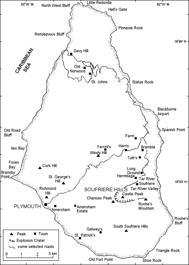 |
Figure 32. Map of Montserrat showing selected towns and features. |
Visual observations. Activity was very high during 14-21 September with moderate-sized pyroclastic flows moving down Tuitt's Ghaut and over Farrell's plain. In the upper reaches of Mosquito Ghaut, material overflowed into Tuitt's Ghaut and created a small debris fan . The largest individual pyroclastic flow in Tuitt's Ghaut occurred on the morning of 17 September, depositing material 200 m beyond the confluence of Tuitt's and Mosquito Ghaut. The dome's SE side continued to degrade, generating rockfall debris and small pyroclastic flows in Tar River.
At 0354 on 21 September a large collapse occurred on the NE flank of the dome. Pyroclastic flows down Tuitt's Ghaut devastated the area from Trant's Yard to White's Yard. The airport terminal building was destroyed as well as most properties in Spanish Point, Bramble, and Tuitt's; in addition, Bethel village was buried. Small fans developed at the mouths of Farm River and White's Ghaut.
Most deposition from the 21 September flows occurred around Trant's Yard and Farm Estate and greatly extended the fan formed on 25 June (BGVN 22:06). A lobe detached from the main Tuitt's Ghaut flow (500 m S of the Mosquito Ghaut confluence) and spread ENE across Bramble village. The deposit was similar to that of the Bethel lobe emplaced on 25 June, consisting of a thin, ashy unit with abundant large blocks sized from one to several meters. Material also spilled from Tuitt's Ghaut into White's Ghaut at a low point in the valley wall. Pyroclastic flows that reached the sea were generated in White's Ghaut; extensive surges traveled over Tuitt's Estate, Bethel Estate, and White's Yard. The collapse generated ~8 x 10⁶ m3 of deposits, a considerably larger volume than on 25 June.
Following the 21 September collapse, a series of Vulcanian explosions began at 0055 on 22 September. During 22-28 September, 15 explosions occurred with an average periodicity of 9.7 hours. The explosions were similar to those of early August (BGVN 22:08); they began with dark-gray explosion clouds comprised of radiating spears. The clouds quickly rose 600-1,000 m above the dome and developed into convecting columns. A rapidly building roar was heard and ballistics were projected up to 1.5 km from the dome during the explosions. Pyroclastic flows were generated during most explosions and traveled down all the six major ghauts (Tar River, Tuitt's, Mosquito, Tyre's, Gages, and White River). The explosion columns rose up to 7,600 m; after each explosion, vigorous pulses of ash venting were observed for up to 1 hour and low rumbling sounds were heard for up to 30 minutes. At night the explosions resembled a large fireball above the volcano; showers of incandescent ballistics occurred over Farrell's plain, Gages Mountain, and Chances Peak. Incandescent surges were seen on several occasions traveling over Farrell's plain and down Tuitt's Ghaut. At the onset of one explosion, observers at Jack Boy Hill saw high levels of gas venting from fumaroles on the dome's E flank.
Thin, pumiceous pyroclastic-flow deposits were generated by the explosions during 22-28 September. They were generated by fountain collapse; a veneer of pumice was left over the area between Gages and Peak 'C', over Chances Peak, over the Galways area, and over much of the dome's surface. The flows were generated soon after the onset of the explosions. Maximum runout distances were ~4.5 km in Tuitt's Ghaut, 2.25 km in Tyre's Ghaut, 4 km in White River, 2.6 km down Gages Valley, and 2.5 km down Farrell's Plain; flows reached the sea at Tar River. In unconfined areas such as the Tar River Fan, the Farrell's Plain, and the Trant's Farm Fan, the flows left long, thin, tongue-like deposits and rarely spread into thin sheets. Flows confined to narrow ghauts were thicker, narrower, and had steeper termini.
Fallout from the 22-28 September explosions varied. Most of N and W Montserrat had moderate ash falls including pumice fragments. Pumice fragments were recorded at the Observatory on Mango Hill and at Little Bay (2 cm), at Cudjoehead and Olveston (3 cm), and on Davy Hill (5 cm). A 6-cm pumice was reported in Woodlands.
During 14-28 September, observations of the dome showed that the scar above Tuitt's Ghaut extended 300 m into the dome; it opened into an explosion crater ~300 m diameter. A bank of pumice and talus separated the crater and the scar; depth of the crater below the bank was ~150 m. Much of the dome's surface and the upper area of Chances Peak were covered by fresh pumice deposits. Two of the three peaks on the northern crater wall (Peaks 'B' and 'C') had severely eroded; they were nearly covered by the dome talus and pumice deposits.
A total of 32 explosions occurred during 28 September-12 October with an average periodicity of ~10 hours, although the intervals varied in duration from 4.9 to 33.7 hours. Explosions after shorter intervals were weaker, produced paler, less vigorous plumes, and were accompanied by smaller pyroclastic flows.
Pyroclastic flows during 28 September-12 October were concentrated in Tuitt's Ghaut and the Tar River Valley, although regular activity also occurred in the White River, Fort Ghaut, and over the Farrell's Plain. Many of the Tuitt's Ghaut flows traveled 4-4.5 km, building a 300-m-wide fan around the Farms and Trants area. The flows over-spilled the ghaut walls in several locations and spread over a wide area, traveling ENE and passing through Spanish Point where they reached the sea. Many pyroclastic flows in the Tar River area reached the sea by traveling down the S side of the valley and down two chutes on the dome's E face. The surface of the fan was almost entirely covered by new pyroclastic-flow deposits; a pronounced hump along the fan's central axis developed. Pyroclastic flow activity in White's River was more limited with only a few flows reaching the area where Great Alps Falls had been. However, pyroclastic flows from an explosion at 0105 on 2 October covered the bridge at O'Garra's, reaching the sea at the mouth of the White River.
A large explosion at 1757 on 11 October covered the field at O'Garra's with pyroclastic-flow deposits, destroyed the Radio Antilles installation, and completely buried a bridge. Incandescent blocks and a glowing cloud were seen from Antigua during the event. Flows in Fort Ghaut spread NW around the Gages fan, W around Upper Amersham and into Plymouth. The Plymouth flows spread through Dagenham and reached within 300 m of the sea. Occasional pyroclastic flows have occurred in Tyer's Ghaut, although the longest runouts were only ~2 km.
Plume heights from the 28 September-12 October explosions varied from 3.6 to 7.6 km. Pumice fallout in inhabited areas only occurred on 1 and 2 October, although heavy ashfall occurred many times on the rest of the island. Antigua received light ashfall on three occasions.
Very good views of the dome were obtained during 28 September-12 October. At the base of the scar above Tuitt's Ghaut, the bank of pumice and talus was steep and appeared consolidated. The lowest point on the bank was 860 m above sea level; behind it was the circular explosion crater, 300 m in diameter. The crater rim had a fairly constant elevation of ~950 m. The highest point on the dome was a spine on the rim above Galways with an elevation of 975 m. Glimpses down into the explosion crater suggested its base was 100-150 m below the level of the pumice and talus bank, probably close to the level of the original English's Crater basement. The crater and scar have both been enlarged slightly by rockfalls from the inner walls, by erosion, and by shaking during the explosions. Chutes were developing along both sides of a large consolidated area of the dome above Galways and the SE flank in the Tar River Valley was degrading slowly.
Much erosion occurred around the margins of the dome on the old crater wall. Peak B on the N crater wall was lowered by 30 m due to the passage of pyroclastic flows this summer. A 90-m-wide chute was cut down the Gages Valley face of the dome immediately S of the original Gages Wall against Chances Peak. This chute was up to 50 m deep and cut at least 30 m into the original basement in places.
Seismicity. During 14-20 September, seismicity was dominated by rockfall and pyroclastic-flow signals. There were few earthquakes, although the pyroclastic flow on 14 September was preceded by a hybrid swarm that included some large events. The hybrids had amplitudes as high as any recorded since the installation of the broadband network in October 1996 at the Windy Hill station. An unusually high number of long-period earthquakes occurred before, rather than after, pyroclastic flows. On 16 September, a "bang" related to a long-period earthquake was heard.
The night of 20-21 September showed a marked change in seismicity. A hybrid swarm occurred before a big pyroclastic flow at 0354, but the hybrids did not decrease very much after the event. Then at 0055 on 22 September, the first in a sequence of explosive events took place that occurred at intervals of 6-10 hours during 22-28 September. As in August, each explosion was recorded on seismometers as a pyroclastic-flow signal preceded by a ~1 Hz signal whose amplitude varied with the associated pyroclastic-flow amplitude. The long- period energy continued throughout the pyroclastic-flow signal and afterwards as low-amplitude tremor. A few explosions were preceded by hybrid swarms, but most had very little precursory seismicity. When swarms occurred, they continued for a short time after the explosion. All of the explosions were followed by between 20 minutes and 3 hours of tremor. The tremor was less harmonic than in August but had two or three well-defined spectral peaks. As in August there was good visual confirmation that the tremor correlated with ash venting. Volcano-tectonic earthquakes during 22-28 September were centered 2-4 km below the dome.
Seismicity was low during 28 September-12 October, except during explosions and subsequent tremor, which on occasion lasted several hours. The explosions, as in August (BGVN 22:08), had a distinctive seismic signal, with an initial low-frequency phase followed by a high-frequency phase and low- frequency tremor. The high-frequency phases are assumed to be caused by pyroclastic flows observed after each explosion. Low-frequency tremor at the start of the signals preceded observed activity in the crater by several seconds. It is assumed to continue throughout the pyroclastic flow signal and become the post-explosion tremor. Both the low frequency phase and the tremor have the same peaked spectrum with the main peaks at 1.2 and 1.7 Hz.
Ground deformation. On 20 September, GPS observations taken at Harris, White's, Long Ground, and Hermitage confirmed the shortening noted in recent reports on the Harris-White's and Harris-Long Ground lines. The length of shortening was ~3.5 cm on these lines due to N movement of White's and Long Ground. The movement did not appear to be accelerating. The Hermitage site was not occupied due to the activity on the NE side since 21 May. The line to Harris showed a further 1-cm shortening (NE movement of Hermitage) consistent with its movement in May. The White's site was affected the following morning by pyroclastic surges. The activity also damaged the permanent GPS site at White's.
No EDM measurements were made during 14-28 September. Ash from pyroclastic flows and explosions obscured the target at Lee's Yard and it was unsafe to enter the area to clean the reflector. No GPS observations were made during 28 September-12 October. The amount of ash on the N, E, and W flanks prevented the helicopter from landing at all but two sites. The O'Garra's GPS site (M46) was destroyed by pyroclastic flows on 11 October. EDM measurements to the Lees reflector were not possible due to ash cover and airborne ash.
Volume measurements. No dome or deposit volume measurements were made during 14- 28 September; however, photographs were obtained from the ground at Whites and from a hover position close to Windy Hill.
A series of accuracy tests were carried out with GPS-laser binoculars from a helicopter to assess their suitability for dome mapping. The working range for this instrument has typically been 400 m.
Several clear days during early October allowed a detailed survey and map of the dome to be completed. Theodolite measurements were made from Jack Boy Hill, Flemings, Garibaldi Hill, and the old observatory in Old Towne. Photographs were taken from White's, Harris, and Jack Boy Hill. A series of photographs at different angles around the dome were taken from the helicopter; the position of the camera was determined with the GPS.
The dome volume was 68 x 106 m3 during early October. The volume has decreased since the last measurement on 28 August when it was 78.1 x 10⁶ m3, at which time the extrusion rate was 8.7 m3/s (average 17 July-28 August). The difference in these volumes represents the volume of the 21 September collapse as well as a substantial amount of pyroclastic flow activity over Farrell's plain and in Tuitt's Ghaut prior to the collapse.
Environmental monitoring. Dust Trak sampling carried out at several sites around the island to evaluate the atmospheric particulate load showed comparatively high values in the N and E area and high values in the Salem area. The central area also showed elevated values. The high levels were the result of fallout from explosive activity.
On 12 September, sulfur dioxide diffusion tubes were collected from four sites to the N of the volcano, at MVO (south), Lawyers, Fogarthy, and Geralds. The diffusion tubes measured the average background level of SO2 during the exposure period. As in previous sampling periods, SO2 gas was not present in measurable quantities. On 4 October, sulfur diffusion tubes were left at Weekes and at St George's Hill in the evacuated zone to be collected after two weeks. Under normal prevailing wind conditions (to the W or NW) the sites lie under the plume. Sulfur diffusion tubes at four sites in the inhabited area of the island were being left for four weeks. Until early October there was no detectable SO2 in the inhabited area.
A mini-COSPEC was deployed on 20 September from a police launch. A series of traverses were made under the plume at different distances from the volcano. The average SO2 flux was 600 metric tons/day. The launch broke down the next day and was out of action for over a month.
Rainwater collected at three sites on 21 September showed low pH. One site also showed substantially elevated chloride content. High acidity levels persisted during late September.
Geological Summary. The complex, dominantly andesitic Soufrière Hills volcano occupies the southern half of the island of Montserrat. The summit area consists primarily of a series of lava domes emplaced along an ESE-trending zone. The volcano is flanked by Pleistocene complexes to the north and south. English's Crater, a 1-km-wide crater breached widely to the east by edifice collapse, was formed about 2000 years ago as a result of the youngest of several collapse events producing submarine debris-avalanche deposits. Block-and-ash flow and surge deposits associated with dome growth predominate in flank deposits, including those from an eruption that likely preceded the 1632 CE settlement of the island, allowing cultivation on recently devegetated land to near the summit. Non-eruptive seismic swarms occurred at 30-year intervals in the 20th century, but no historical eruptions were recorded until 1995. Long-term small-to-moderate ash eruptions beginning in that year were later accompanied by lava-dome growth and pyroclastic flows that forced evacuation of the southern half of the island and ultimately destroyed the capital city of Plymouth, causing major social and economic disruption.
Information Contacts: Montserrat Volcano Observatory (MVO), c/o Chief Minister's Office, PO Box 292, Plymouth, Montserrat (URL: http://www.mvo.ms/).